Waynesfield Topo Map Ohio
To zoom in, hover over the map of Waynesfield
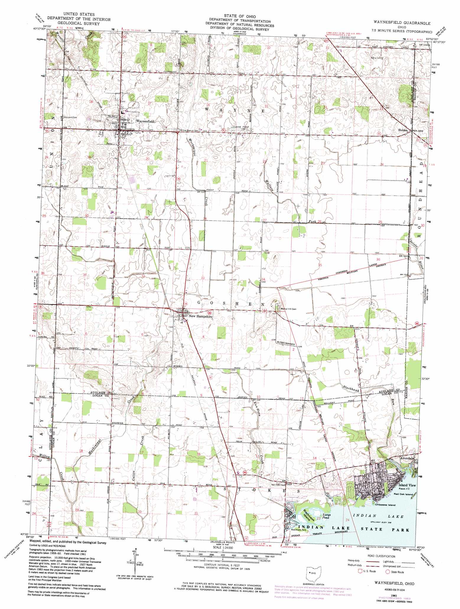
USGS Topo Quad 40083e8 - 1:24,000 scale
| Topo Map Name: | Waynesfield |
| USGS Topo Quad ID: | 40083e8 |
| Print Size: | ca. 21 1/4" wide x 27" high |
| Southeast Coordinates: | 40.5° N latitude / 83.875° W longitude |
| Map Center Coordinates: | 40.5625° N latitude / 83.9375° W longitude |
| U.S. State: | OH |
| Filename: | o40083e8.jpg |
| Download Map JPG Image: | Waynesfield topo map 1:24,000 scale |
| Map Type: | Topographic |
| Topo Series: | 7.5´ |
| Map Scale: | 1:24,000 |
| Source of Map Images: | United States Geological Survey (USGS) |
| Alternate Map Versions: |
Waynesfield OH 1961, updated 1962 Download PDF Buy paper map Waynesfield OH 1961, updated 1975 Download PDF Buy paper map Waynesfield OH 1961, updated 1983 Download PDF Buy paper map Waynesfield OH 2010 Download PDF Buy paper map Waynesfield OH 2013 Download PDF Buy paper map Waynesfield OH 2016 Download PDF Buy paper map |
1:24,000 Topo Quads surrounding Waynesfield
Elida |
Cairo |
Beaverdam |
Ada |
Dunkirk |
Cridersville |
Lima |
Harrod |
Alger |
Foraker |
Wapakoneta |
Uniopolis |
Waynesfield |
Roundhead |
Silver Creek |
Botkins |
Jackson Center |
Russells Point |
Huntsville |
Rushsylvania |
Sidney |
Port Jefferson |
De Graff |
Bellefontaine |
Zanesfield |
> Back to 40083e1 at 1:100,000 scale
> Back to 40082a1 at 1:250,000 scale
> Back to U.S. Topo Maps home
Waynesfield topo map: Gazetteer
Waynesfield: Canals
Scioto River Ditch elevation 311m 1020′Waynesfield: Islands
Blackhawk Island elevation 304m 997′Chippewa Island elevation 304m 997′
Fawn Island elevation 305m 1000′
Red Oak Island elevation 305m 1000′
Waynesfield: Parks
Blackhawk Park elevation 304m 997′Waynesfield: Populated Places
Holden elevation 316m 1036′Island View elevation 309m 1013′
New Hampshire elevation 315m 1033′
Waynesfield elevation 324m 1062′
Waynesfield: Post Offices
Island View Post Office (historical) elevation 309m 1013′New Hampshire Post Office elevation 315m 1033′
Waynesfield Post Office elevation 324m 1062′
Waynesfield: Reservoirs
Lucys Pond elevation 304m 997′Waynesfield: Streams
Blackhawk Run elevation 303m 994′Van Horn Creek elevation 303m 994′
Wallace Fork elevation 310m 1017′
Willow Creek elevation 303m 994′
Waynesfield digital topo map on disk
Buy this Waynesfield topo map showing relief, roads, GPS coordinates and other geographical features, as a high-resolution digital map file on DVD:
 map DVD")