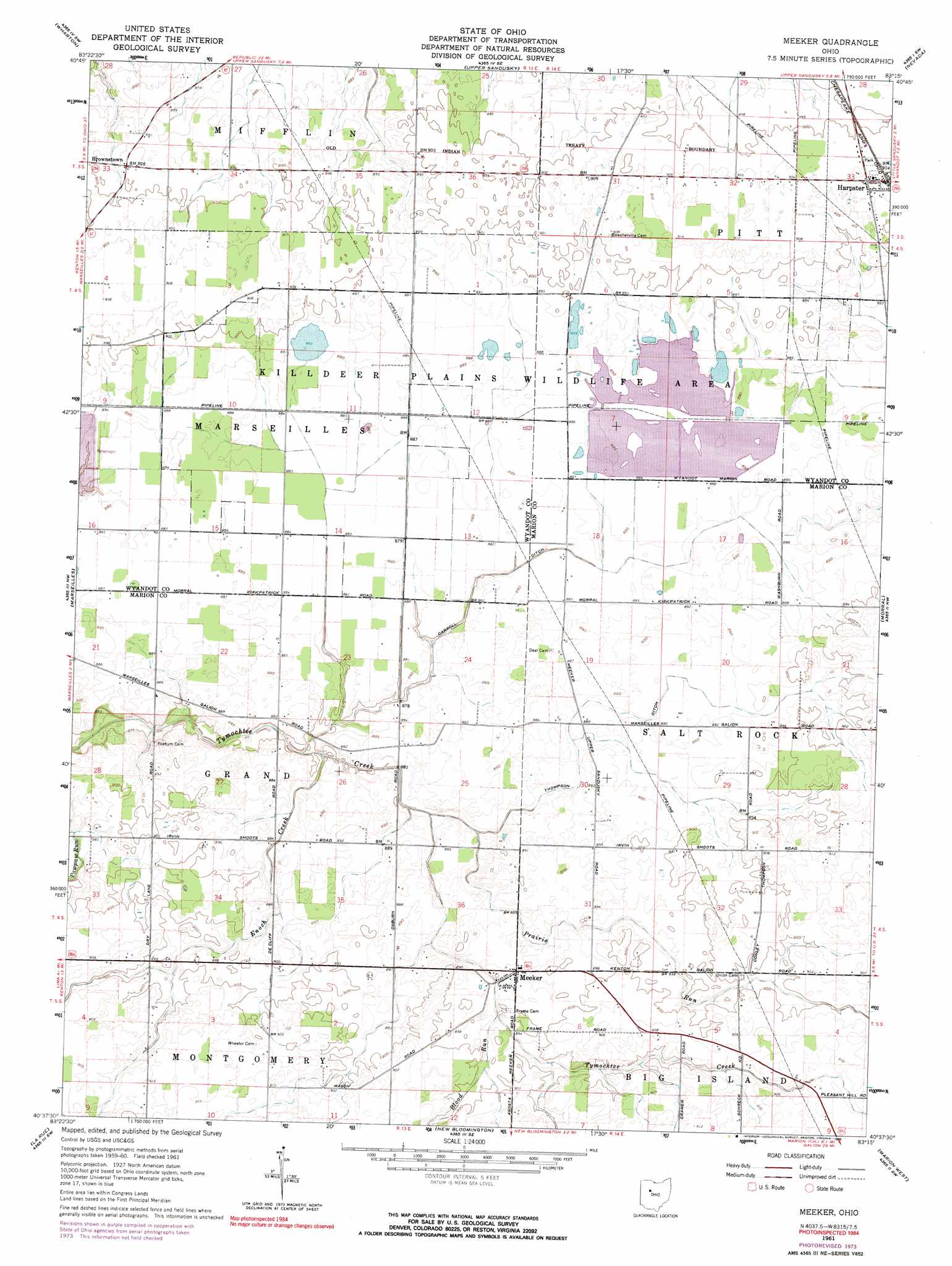
Meeker Topo Map Ohio
To zoom in, hover over the map of Meeker
USGS Topo Quad 40083f3 - 1:24,000 scale
| Topo Map Name: | Meeker |
| USGS Topo Quad ID: | 40083f3 |
| Print Size: | ca. 21 1/4" wide x 27" high |
| Southeast Coordinates: | 40.625° N latitude / 83.25° W longitude |
| Map Center Coordinates: | 40.6875° N latitude / 83.3125° W longitude |
| U.S. State: | OH |
| Filename: | o40083f3.jpg |
| Download Map JPG Image: | Meeker topo map 1:24,000 scale |
| Map Type: | Topographic |
| Topo Series: | 7.5´ |
| Map Scale: | 1:24,000 |
| Source of Map Images: | United States Geological Survey (USGS) |
| Alternate Map Versions: |
Meeker OH 1961, updated 1962 Download PDF Buy paper map Meeker OH 1961, updated 1974 Download PDF Buy paper map Meeker OH 1961, updated 1990 Download PDF Buy paper map Meeker OH 2010 Download PDF Buy paper map Meeker OH 2013 Download PDF Buy paper map Meeker OH 2016 Download PDF Buy paper map |
1:24,000 Topo Quads surrounding Meeker
Mount Blanchard |
Carey |
Mccutchenville |
Sycamore |
Lykens |
Forest |
Wharton |
Upper Sandusky |
Nevada |
Oceola |
Kenton |
Marseilles |
Meeker |
Morral |
Monnett |
Mount Victory |
La Rue |
New Bloomington |
Marion West |
Marion East |
West Mansfield |
York Center |
Richwood |
Prospect |
Waldo |
> Back to 40083e1 at 1:100,000 scale
> Back to 40082a1 at 1:250,000 scale
> Back to U.S. Topo Maps home
Meeker topo map: Gazetteer
Meeker: Canals
Carroll Ditch elevation 268m 879′Thompson Ditch elevation 270m 885′
Meeker: Dams
Killdeer Wildlife Pond Dam Number One elevation 269m 882′Killdeer Wildlife Pond Dam Number Three elevation 269m 882′
Killdeer Wildlife Pond Dam Number Two elevation 270m 885′
Meeker: Parks
Killdeer Plains Wildlife Area elevation 271m 889′Meeker: Populated Places
Bowsherville (historical) elevation 277m 908′Brownstown elevation 272m 892′
Harpster elevation 276m 905′
Meeker elevation 273m 895′
Meeker: Post Offices
Bowshersville Post Office (historical) elevation 276m 905′Harpster Post Office elevation 276m 905′
Meeker Post Office (historical) elevation 273m 895′
Meeker: Reservoirs
Killdeer Wildlife Pond Number One elevation 269m 882′Killdeer Wildlife Pond Number Three elevation 269m 882′
Killdeer Wildlife Pond Number Two elevation 270m 885′
Meeker: Streams
Blood Run elevation 273m 895′Enoch Creek elevation 265m 869′
Prairie Run elevation 267m 875′
Meeker digital topo map on disk
Buy this Meeker topo map showing relief, roads, GPS coordinates and other geographical features, as a high-resolution digital map file on DVD:
 map DVD")