Rossburg Topo Map Ohio
To zoom in, hover over the map of Rossburg
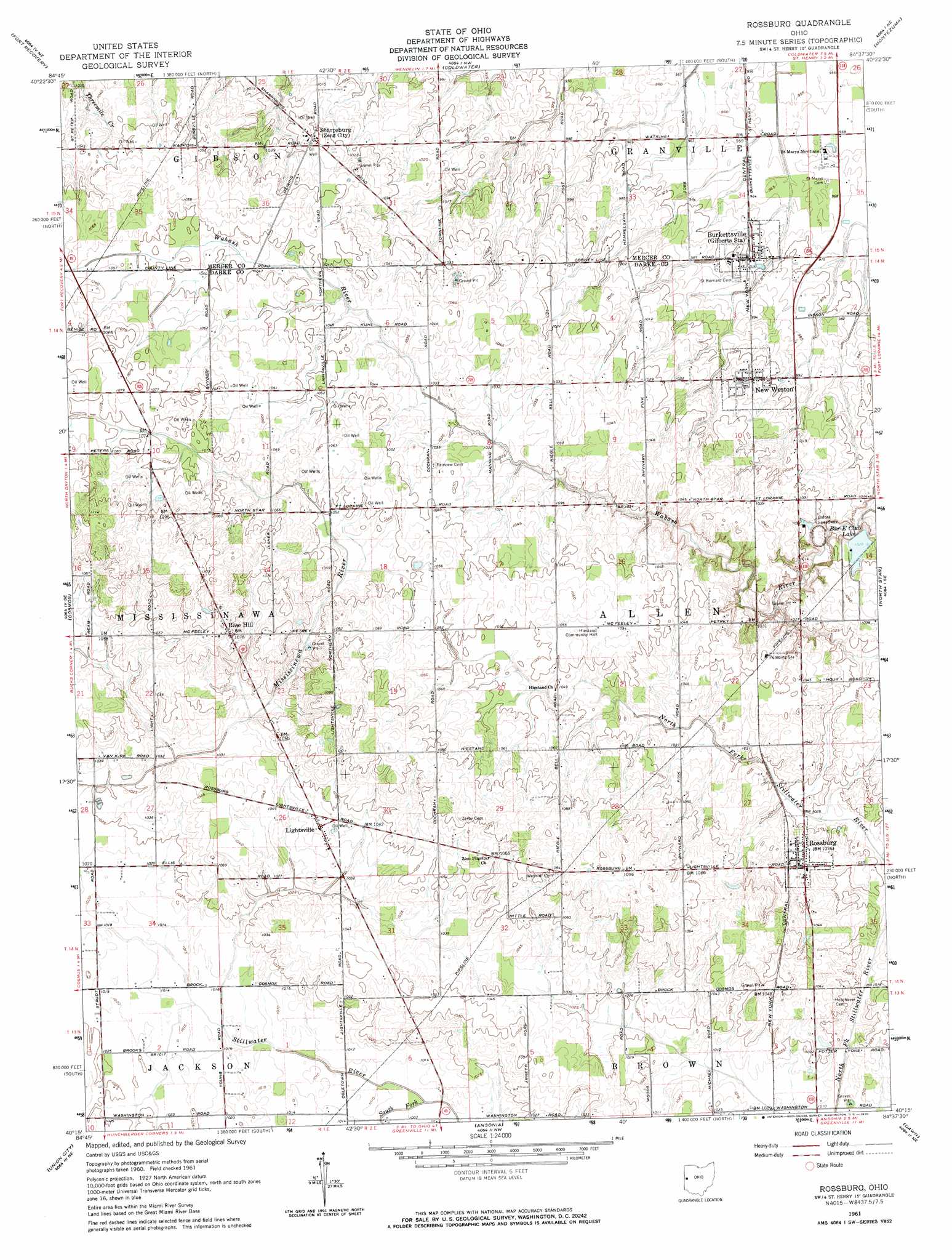
USGS Topo Quad 40084c6 - 1:24,000 scale
| Topo Map Name: | Rossburg |
| USGS Topo Quad ID: | 40084c6 |
| Print Size: | ca. 21 1/4" wide x 27" high |
| Southeast Coordinates: | 40.25° N latitude / 84.625° W longitude |
| Map Center Coordinates: | 40.3125° N latitude / 84.6875° W longitude |
| U.S. State: | OH |
| Filename: | o40084c6.jpg |
| Download Map JPG Image: | Rossburg topo map 1:24,000 scale |
| Map Type: | Topographic |
| Topo Series: | 7.5´ |
| Map Scale: | 1:24,000 |
| Source of Map Images: | United States Geological Survey (USGS) |
| Alternate Map Versions: |
Rossburg OH 1961, updated 1962 Download PDF Buy paper map Rossburg OH 1961, updated 1970 Download PDF Buy paper map Rossburg OH 2010 Download PDF Buy paper map Rossburg OH 2013 Download PDF Buy paper map Rossburg OH 2016 Download PDF Buy paper map |
1:24,000 Topo Quads surrounding Rossburg
Geneva |
New Corydon |
Erastus |
Celina |
Saint Marys |
Portland |
Fort Recovery |
Coldwater |
Montezuma |
New Bremen |
Deerfield |
Cosmos |
Rossburg |
North Star |
Osgood |
Winchester |
Union City |
Ansonia |
Dawn |
Versailles |
Lynn |
Spartanburg |
Greenville West |
Greenville East |
Gettysburg |
> Back to 40084a1 at 1:100,000 scale
> Back to 40084a1 at 1:250,000 scale
> Back to U.S. Topo Maps home
Rossburg topo map: Gazetteer
Rossburg: Canals
Ross Lateral elevation 306m 1003′Rossburg: Dams
Bar-E Club Lake Dam elevation 303m 994′Upper Wabash Structure Number Two Dam elevation 300m 984′
Rossburg: Populated Places
Burkettsville elevation 297m 974′Lightsville elevation 317m 1040′
New Weston elevation 308m 1010′
Rose Hill elevation 329m 1079′
Rossburg elevation 314m 1030′
Sharpsburg elevation 314m 1030′
Rossburg: Post Offices
Berkettsville Post Office elevation 297m 974′Lightsville Post Office (historical) elevation 317m 1040′
New Weston Post Office elevation 307m 1007′
Rosehill Post Office (historical) elevation 327m 1072′
Rossburg Post Office elevation 314m 1030′
Rossburg: Reservoirs
Bar-E Club Lake elevation 303m 994′Upper Wabash Structure Number Two Reservoir elevation 300m 984′
Wabash Conservancy District Structure Reservoir elevation 308m 1010′
Rossburg: Streams
South Fork Stillwater River elevation 303m 994′Rossburg digital topo map on disk
Buy this Rossburg topo map showing relief, roads, GPS coordinates and other geographical features, as a high-resolution digital map file on DVD:
Northern Illinois, Northern Indiana & Southwestern Michigan
Buy digital topo maps: Northern Illinois, Northern Indiana & Southwestern Michigan