Celina Topo Map Ohio
To zoom in, hover over the map of Celina
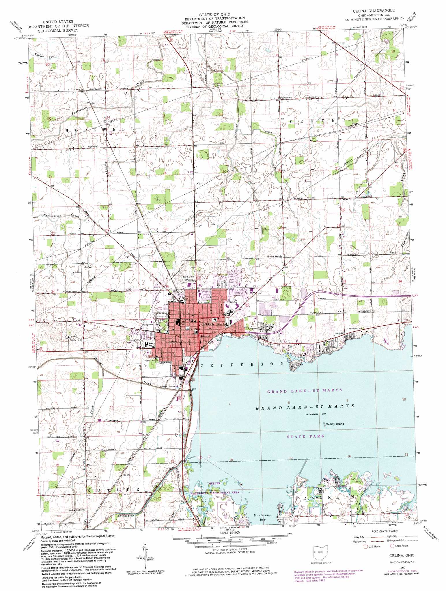
USGS Topo Quad 40084e5 - 1:24,000 scale
| Topo Map Name: | Celina |
| USGS Topo Quad ID: | 40084e5 |
| Print Size: | ca. 21 1/4" wide x 27" high |
| Southeast Coordinates: | 40.5° N latitude / 84.5° W longitude |
| Map Center Coordinates: | 40.5625° N latitude / 84.5625° W longitude |
| U.S. State: | OH |
| Filename: | o40084e5.jpg |
| Download Map JPG Image: | Celina topo map 1:24,000 scale |
| Map Type: | Topographic |
| Topo Series: | 7.5´ |
| Map Scale: | 1:24,000 |
| Source of Map Images: | United States Geological Survey (USGS) |
| Alternate Map Versions: |
Celina OH 1960, updated 1961 Download PDF Buy paper map Celina OH 1960, updated 1974 Download PDF Buy paper map Celina OH 1960, updated 1983 Download PDF Buy paper map Celina OH 2010 Download PDF Buy paper map Celina OH 2013 Download PDF Buy paper map Celina OH 2016 Download PDF Buy paper map |
1:24,000 Topo Quads surrounding Celina
Wren |
Glenmore |
Van Wert |
Middle Point |
Delphos |
Willshire |
Rockford |
Mendon |
Elgin |
Spencerville |
New Corydon |
Erastus |
Celina |
Saint Marys |
Moulton |
Fort Recovery |
Coldwater |
Montezuma |
New Bremen |
New Knoxville |
Cosmos |
Rossburg |
North Star |
Osgood |
Fort Loramie |
> Back to 40084e1 at 1:100,000 scale
> Back to 40084a1 at 1:250,000 scale
> Back to U.S. Topo Maps home
Celina topo map: Gazetteer
Celina: Bays
Montezuma Bay elevation 264m 866′Celina: Canals
Blierdofer Ditch elevation 254m 833′Green Ditch elevation 256m 839′
Houtz Ditch elevation 250m 820′
Wenskes Ditch elevation 253m 830′
Celina: Capes
Harbor Point elevation 266m 872′Windy Point elevation 265m 869′
Celina: Islands
Eagle Island (historical) elevation 264m 866′Green Island (historical) elevation 264m 866′
Safety Island elevation 265m 869′
Celina: Parks
Celina Main Street Commercial Historic District elevation 267m 875′Eastview Park elevation 270m 885′
Harbor Point State Park elevation 267m 875′
Mercelina Park elevation 266m 872′
North Shore Park elevation 266m 872′
Pullman Bay Park elevation 265m 869′
Westview Park elevation 266m 872′
Celina: Populated Places
Bass Landing elevation 265m 869′Celina elevation 267m 875′
Coldwater Beach elevation 265m 869′
Earley (historical) elevation 254m 833′
Grand Lake Mobile Home Park elevation 265m 869′
Harbor Point elevation 268m 879′
Highland Park elevation 268m 879′
Lakeland Beach elevation 269m 882′
Mariners Point elevation 268m 879′
Montezuma Acres elevation 266m 872′
Sleepy Hollow Acres elevation 270m 885′
The Maples elevation 265m 869′
Turtle Neck Point elevation 266m 872′
Woodhaven Mobile Home Park elevation 266m 872′
Celina: Post Offices
Celina Post Office elevation 267m 875′Earley Post Office (historical) elevation 254m 833′
Celina: Streams
Burntwood Creek elevation 265m 869′Coldwater Creek elevation 264m 866′
Grassy Creek elevation 264m 866′
Hardin Creek elevation 260m 853′
Monroe Creek elevation 265m 869′
Prairie Creek elevation 264m 866′
Celina digital topo map on disk
Buy this Celina topo map showing relief, roads, GPS coordinates and other geographical features, as a high-resolution digital map file on DVD:
Northern Illinois, Northern Indiana & Southwestern Michigan
Buy digital topo maps: Northern Illinois, Northern Indiana & Southwestern Michigan