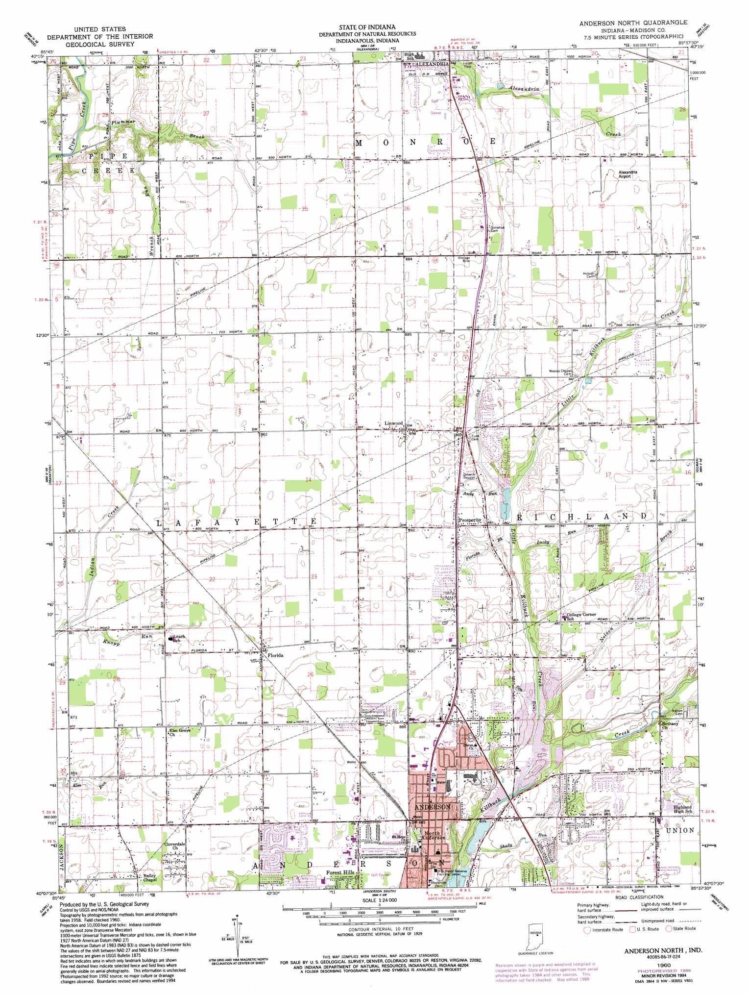
Anderson North Topo Map Indiana
To zoom in, hover over the map of Anderson North
USGS Topo Quad 40085b6 - 1:24,000 scale
| Topo Map Name: | Anderson North |
| USGS Topo Quad ID: | 40085b6 |
| Print Size: | ca. 21 1/4" wide x 27" high |
| Southeast Coordinates: | 40.125° N latitude / 85.625° W longitude |
| Map Center Coordinates: | 40.1875° N latitude / 85.6875° W longitude |
| U.S. State: | IN |
| Filename: | o40085b6.jpg |
| Download Map JPG Image: | Anderson North topo map 1:24,000 scale |
| Map Type: | Topographic |
| Topo Series: | 7.5´ |
| Map Scale: | 1:24,000 |
| Source of Map Images: | United States Geological Survey (USGS) |
| Alternate Map Versions: |
Anderson North IN 1960, updated 1961 Download PDF Buy paper map Anderson North IN 1960, updated 1978 Download PDF Buy paper map Anderson North IN 1960, updated 1982 Download PDF Buy paper map Anderson North IN 1960, updated 1988 Download PDF Buy paper map Anderson North IN 1960, updated 1994 Download PDF Buy paper map Anderson North IN 2010 Download PDF Buy paper map Anderson North IN 2013 Download PDF Buy paper map Anderson North IN 2016 Download PDF Buy paper map |
1:24,000 Topo Quads surrounding Anderson North
Greentown |
Point Isabel |
Fairmount |
Gas City |
Hartford City West |
Windfall |
Elwood |
Alexandria |
Gaston |
Wheeling |
Omega |
Frankton |
Anderson North |
Gilman |
Muncie West |
Riverwood |
Lapel |
Anderson South |
Middletown |
Sulphur Springs |
Mccordsville |
Ingalls |
Pendleton |
Shirley |
New Castle West |
> Back to 40085a1 at 1:100,000 scale
> Back to 40084a1 at 1:250,000 scale
> Back to U.S. Topo Maps home
Anderson North topo map: Gazetteer
Anderson North: Airports
Alexandria Airport elevation 273m 895′Community Hospital Airport elevation 268m 879′
H and R Skylane Airport elevation 266m 872′
Anderson North: Canals
Old Canal elevation 263m 862′Anderson North: Parks
Shadyside Park elevation 264m 866′Anderson North: Populated Places
Florida elevation 271m 889′Linwood elevation 273m 895′
North Anderson elevation 268m 879′
Prosperity elevation 271m 889′
Anderson North: Streams
Andy Run elevation 263m 862′Florida Brook elevation 261m 856′
Indian Creek elevation 262m 859′
Knopp Run elevation 262m 859′
Little Killbuck Creek elevation 255m 836′
Lucky Run elevation 261m 856′
Nelson Brook elevation 260m 853′
Plummer Brook elevation 251m 823′
Shady Run elevation 254m 833′
Wrench Run elevation 255m 836′
Anderson North digital topo map on disk
Buy this Anderson North topo map showing relief, roads, GPS coordinates and other geographical features, as a high-resolution digital map file on DVD:
Northern Illinois, Northern Indiana & Southwestern Michigan
Buy digital topo maps: Northern Illinois, Northern Indiana & Southwestern Michigan