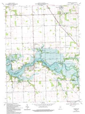
Somerset Topo Map Indiana
To zoom in, hover over the map of Somerset
USGS Topo Quad 40085f7 - 1:24,000 scale
| Topo Map Name: | Somerset |
| USGS Topo Quad ID: | 40085f7 |
| Print Size: | ca. 21 1/4" wide x 27" high |
| Southeast Coordinates: | 40.625° N latitude / 85.75° W longitude |
| Map Center Coordinates: | 40.6875° N latitude / 85.8125° W longitude |
| U.S. State: | IN |
| Filename: | o40085f7.jpg |
| Download Map JPG Image: | Somerset topo map 1:24,000 scale |
| Map Type: | Topographic |
| Topo Series: | 7.5´ |
| Map Scale: | 1:24,000 |
| Source of Map Images: | United States Geological Survey (USGS) |
| Alternate Map Versions: |
Somerset IN 1953, updated 1954 Download PDF Buy paper map Somerset IN 1969, updated 1971 Download PDF Buy paper map Somerset IN 1969, updated 1971 Download PDF Buy paper map Somerset IN 1969, updated 1994 Download PDF Buy paper map Somerset IN 2010 Download PDF Buy paper map Somerset IN 2013 Download PDF Buy paper map Somerset IN 2016 Download PDF Buy paper map |
1:24,000 Topo Quads surrounding Somerset
> Back to 40085e1 at 1:100,000 scale
> Back to 40084a1 at 1:250,000 scale
> Back to U.S. Topo Maps home
Somerset topo map: Gazetteer
Somerset: Parks
Hogback Ridge State Recreation Area elevation 247m 810′Pearson Mill State Recreation Area elevation 241m 790′
Somerset: Populated Places
Mount Vernon elevation 248m 813′Somerset elevation 247m 810′
Treaty elevation 246m 807′
Somerset: Ridges
The Hogback elevation 229m 751′Somerset: Streams
Cart Creek elevation 227m 744′Forked Branch elevation 226m 741′
Goose Creek elevation 218m 715′
Grant Creek elevation 222m 728′
Metocinah Creek elevation 227m 744′
Muddy Branch elevation 221m 725′
Pee Dee Creek elevation 232m 761′
Rock Run elevation 222m 728′
Tenmile Creek elevation 220m 721′
Somerset digital topo map on disk
Buy this Somerset topo map showing relief, roads, GPS coordinates and other geographical features, as a high-resolution digital map file on DVD:
Northern Illinois, Northern Indiana & Southwestern Michigan
Buy digital topo maps: Northern Illinois, Northern Indiana & Southwestern Michigan


