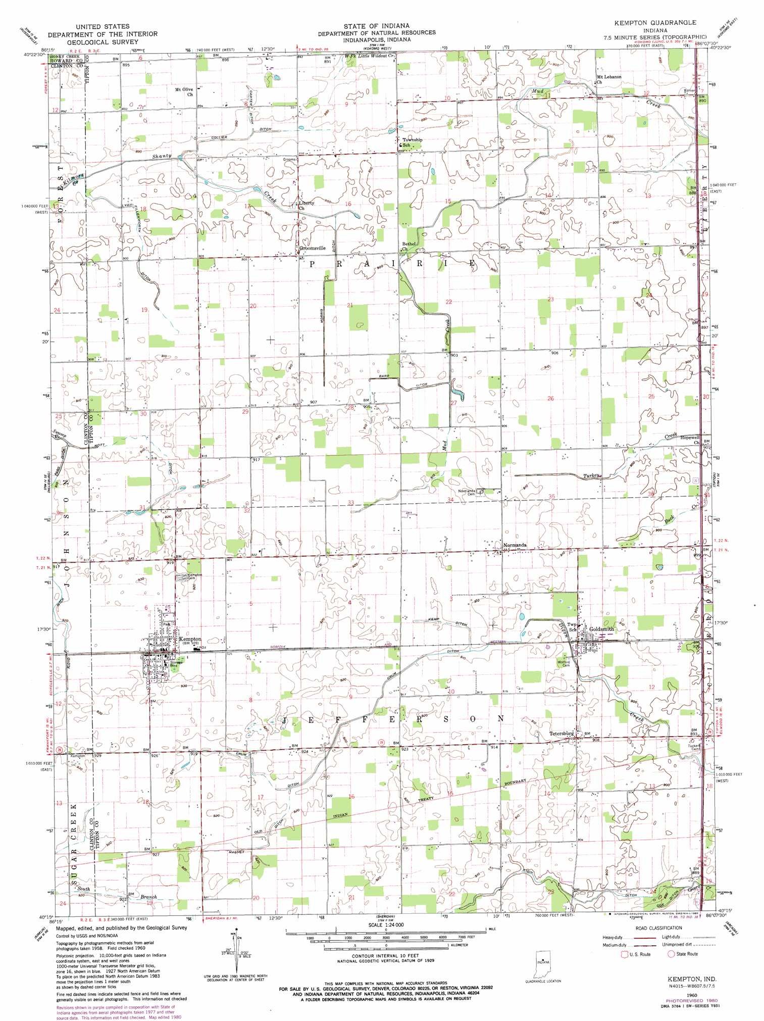
Kempton Topo Map Indiana
To zoom in, hover over the map of Kempton
USGS Topo Quad 40086c2 - 1:24,000 scale
| Topo Map Name: | Kempton |
| USGS Topo Quad ID: | 40086c2 |
| Print Size: | ca. 21 1/4" wide x 27" high |
| Southeast Coordinates: | 40.25° N latitude / 86.125° W longitude |
| Map Center Coordinates: | 40.3125° N latitude / 86.1875° W longitude |
| U.S. State: | IN |
| Filename: | o40086c2.jpg |
| Download Map JPG Image: | Kempton topo map 1:24,000 scale |
| Map Type: | Topographic |
| Topo Series: | 7.5´ |
| Map Scale: | 1:24,000 |
| Source of Map Images: | United States Geological Survey (USGS) |
| Alternate Map Versions: |
Kempton IN 1960, updated 1961 Download PDF Buy paper map Kempton IN 1960, updated 1980 Download PDF Buy paper map Kempton IN 2010 Download PDF Buy paper map Kempton IN 2013 Download PDF Buy paper map Kempton IN 2016 Download PDF Buy paper map |
1:24,000 Topo Quads surrounding Kempton
Deer Creek |
Young America |
Galveston |
Miami |
Amboy |
Burlington |
Russiaville |
Kokomo West |
Kokomo East |
Greentown |
Michigantown |
Hillisburg |
Kempton |
Tipton |
Windfall |
Mechanicsburg |
Kirklin |
Sheridan |
Arcadia |
Omega |
Lebanon |
Rosston |
Westfield |
Noblesville |
Riverwood |
> Back to 40086a1 at 1:100,000 scale
> Back to 40086a1 at 1:250,000 scale
> Back to U.S. Topo Maps home
Kempton topo map: Gazetteer
Kempton: Canals
Barr Ditch elevation 276m 905′Carter Ditch elevation 270m 885′
Collier Ditch elevation 270m 885′
Cox Ditch elevation 270m 885′
Crum Ditch elevation 279m 915′
Floyd Ditch elevation 281m 921′
Kemp Ditch elevation 277m 908′
Kigin Ditch elevation 276m 905′
Lydy-Fillenworth Ditch elevation 273m 895′
Magnet Ditch elevation 280m 918′
Mott Ditch elevation 276m 905′
Yazel Ditch elevation 276m 905′
Kempton: Populated Places
Goldsmith elevation 278m 912′Groomsville elevation 274m 898′
Kempton elevation 283m 928′
Normanda elevation 281m 921′
Tetersburg elevation 277m 908′
Kempton: Streams
Broad Creek elevation 270m 885′Shanty Creek elevation 269m 882′
Kempton digital topo map on disk
Buy this Kempton topo map showing relief, roads, GPS coordinates and other geographical features, as a high-resolution digital map file on DVD:
Northern Illinois, Northern Indiana & Southwestern Michigan
Buy digital topo maps: Northern Illinois, Northern Indiana & Southwestern Michigan