Peru Topo Map Indiana
To zoom in, hover over the map of Peru
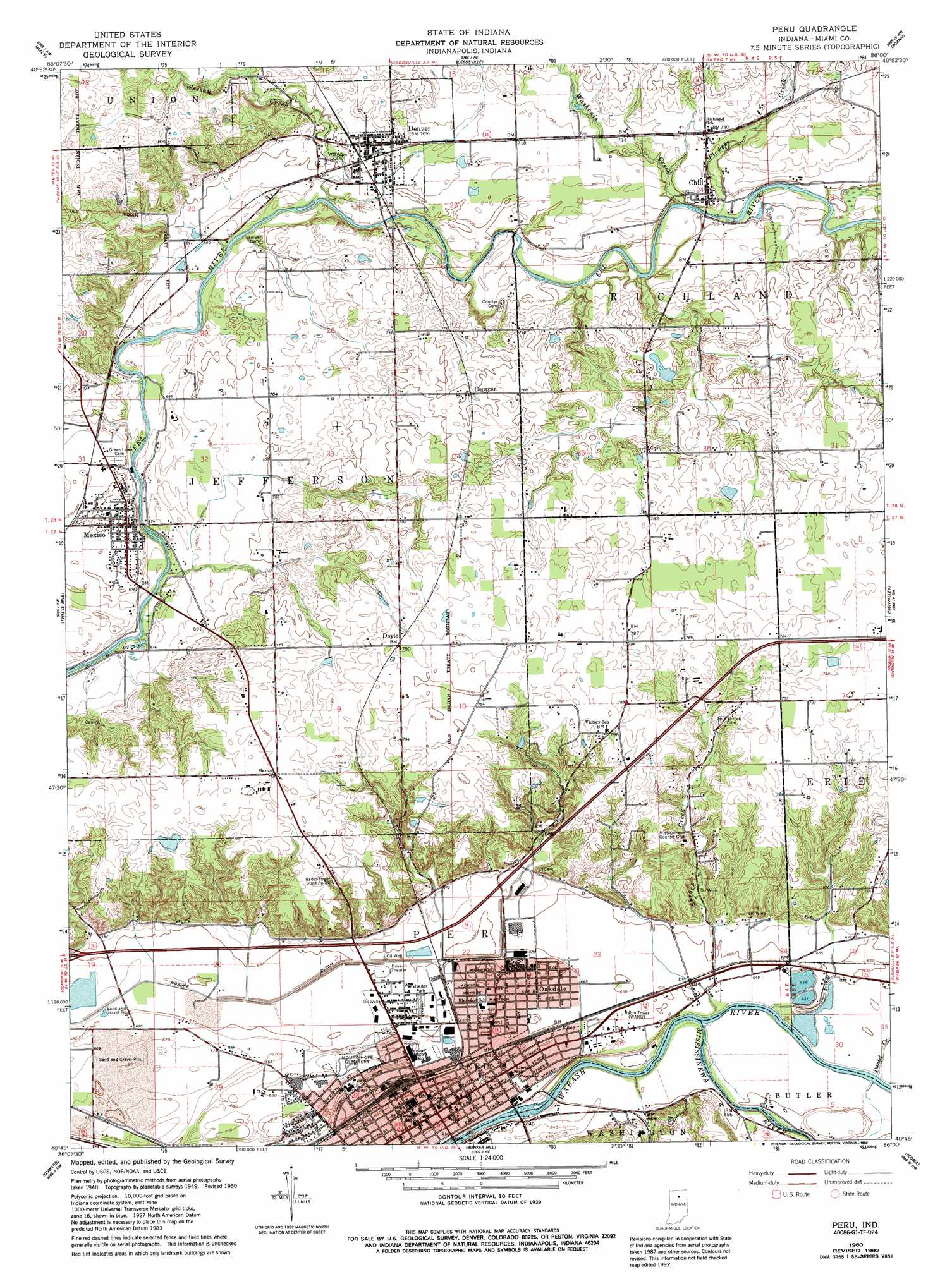
USGS Topo Quad 40086g1 - 1:24,000 scale
| Topo Map Name: | Peru |
| USGS Topo Quad ID: | 40086g1 |
| Print Size: | ca. 21 1/4" wide x 27" high |
| Southeast Coordinates: | 40.75° N latitude / 86° W longitude |
| Map Center Coordinates: | 40.8125° N latitude / 86.0625° W longitude |
| U.S. State: | IN |
| Filename: | o40086g1.jpg |
| Download Map JPG Image: | Peru topo map 1:24,000 scale |
| Map Type: | Topographic |
| Topo Series: | 7.5´ |
| Map Scale: | 1:24,000 |
| Source of Map Images: | United States Geological Survey (USGS) |
| Alternate Map Versions: |
Peru IN 1951 Download PDF Buy paper map Peru IN 1960, updated 1962 Download PDF Buy paper map Peru IN 1960, updated 1962 Download PDF Buy paper map Peru IN 1960, updated 1980 Download PDF Buy paper map Peru IN 1960, updated 1992 Download PDF Buy paper map Peru IN 2010 Download PDF Buy paper map Peru IN 2013 Download PDF Buy paper map Peru IN 2016 Download PDF Buy paper map |
1:24,000 Topo Quads surrounding Peru
Pershing |
Rochester |
Akron |
Silver Lake |
North Manchester North |
Fulton |
Macy |
Deedsville |
Roann |
North Manchester South |
Logansport |
Twelve Mile |
Peru |
Richvalley |
Wabash |
Anoka |
Onward |
Bunker Hill |
Peoria |
Somerset |
Young America |
Galveston |
Miami |
Amboy |
Sweetser |
> Back to 40086e1 at 1:100,000 scale
> Back to 40086a1 at 1:250,000 scale
> Back to U.S. Topo Maps home
Peru topo map: Gazetteer
Peru: Airports
Benner Field elevation 238m 780′Rush Strip Airport elevation 230m 754′
Peru: Canals
Prairie Ditch elevation 196m 643′Peru: Populated Places
Chili elevation 215m 705′Courter elevation 227m 744′
Denver elevation 216m 708′
Doyle elevation 240m 787′
Mexico elevation 214m 702′
Missisinewa (historical) elevation 205m 672′
Oakdale elevation 197m 646′
Peru elevation 199m 652′
Ridgeview elevation 206m 675′
Peru: Streams
Daniel Creek elevation 196m 643′Flowers Creek elevation 208m 682′
Little Weesau Creek elevation 219m 718′
Mississinewa River elevation 194m 636′
Shrock Creek elevation 194m 636′
Washonis Creek elevation 209m 685′
Weesau Creek elevation 206m 675′
Peru digital topo map on disk
Buy this Peru topo map showing relief, roads, GPS coordinates and other geographical features, as a high-resolution digital map file on DVD:
Northern Illinois, Northern Indiana & Southwestern Michigan
Buy digital topo maps: Northern Illinois, Northern Indiana & Southwestern Michigan