Macy Topo Map Indiana
To zoom in, hover over the map of Macy
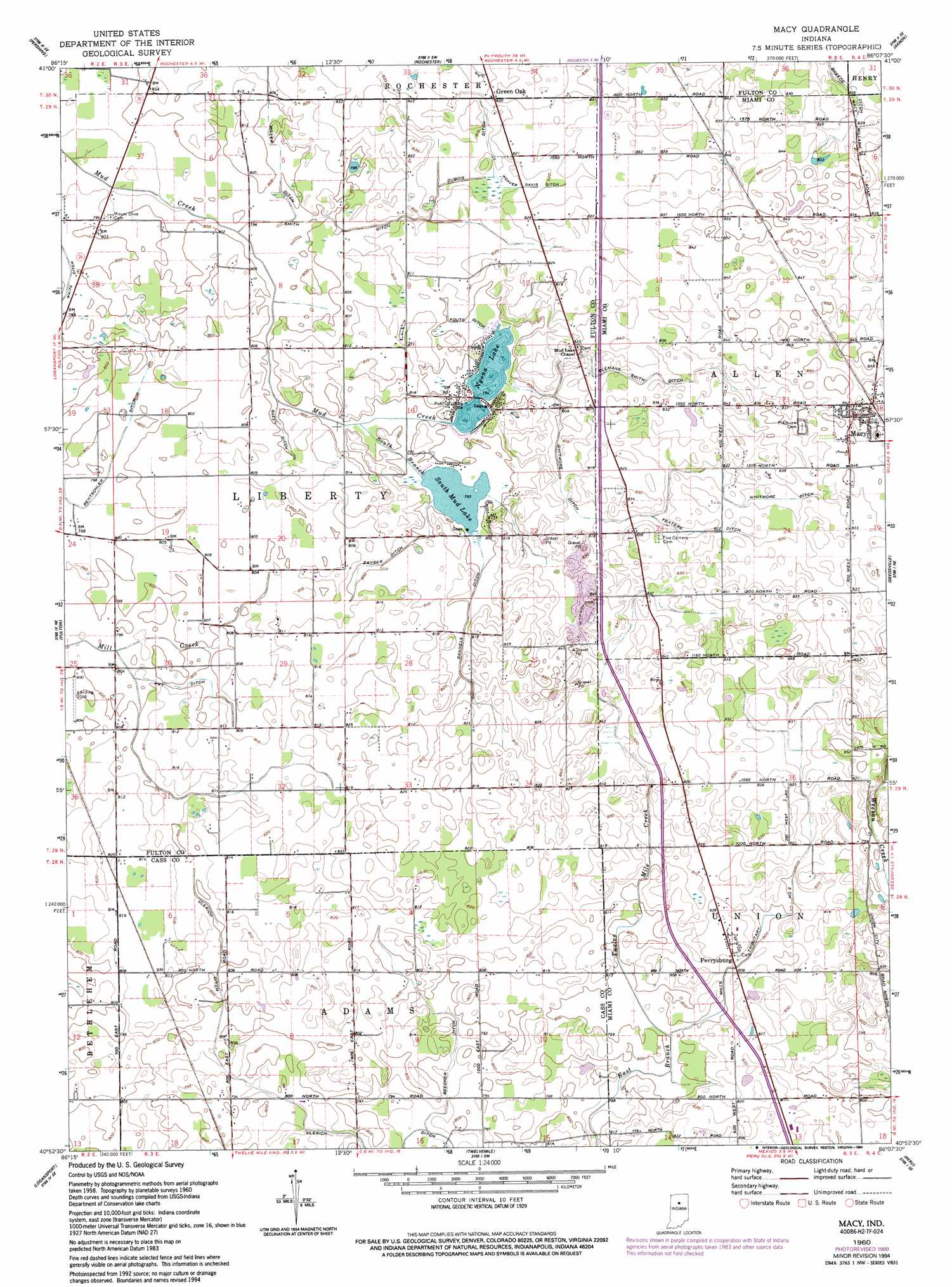
USGS Topo Quad 40086h2 - 1:24,000 scale
| Topo Map Name: | Macy |
| USGS Topo Quad ID: | 40086h2 |
| Print Size: | ca. 21 1/4" wide x 27" high |
| Southeast Coordinates: | 40.875° N latitude / 86.125° W longitude |
| Map Center Coordinates: | 40.9375° N latitude / 86.1875° W longitude |
| U.S. State: | IN |
| Filename: | o40086h2.jpg |
| Download Map JPG Image: | Macy topo map 1:24,000 scale |
| Map Type: | Topographic |
| Topo Series: | 7.5´ |
| Map Scale: | 1:24,000 |
| Source of Map Images: | United States Geological Survey (USGS) |
| Alternate Map Versions: |
Macy IN 1960, updated 1963 Download PDF Buy paper map Macy IN 1960, updated 1980 Download PDF Buy paper map Macy IN 1960, updated 1994 Download PDF Buy paper map Macy IN 2010 Download PDF Buy paper map Macy IN 2013 Download PDF Buy paper map Macy IN 2016 Download PDF Buy paper map |
1:24,000 Topo Quads surrounding Macy
Culver |
Rutland |
Argos |
Mentone |
Burket |
Kewanna |
Pershing |
Rochester |
Akron |
Silver Lake |
Grass Creek |
Fulton |
Macy |
Deedsville |
Roann |
Lucerne |
Logansport |
Twelve Mile |
Peru |
Richvalley |
Clymers |
Anoka |
Onward |
Bunker Hill |
Peoria |
> Back to 40086e1 at 1:100,000 scale
> Back to 40086a1 at 1:250,000 scale
> Back to U.S. Topo Maps home
Macy topo map: Gazetteer
Macy: Canals
Beecher Ditch elevation 241m 790′Breece Ditch elevation 250m 820′
Clemans Smith Ditch elevation 252m 826′
Dubois Ditch elevation 248m 813′
Fenters Ditch elevation 250m 820′
Fouts Ditch elevation 243m 797′
Fry Ditch elevation 243m 797′
Green Ditch elevation 245m 803′
Miller Ditch elevation 242m 793′
Mills Ditch elevation 248m 813′
Mills Tributary Number Two elevation 244m 800′
Rannels Ditch elevation 245m 803′
Rentschler Ditch elevation 242m 793′
Smith Ditch elevation 245m 803′
Ulerich Ditch elevation 242m 793′
Weaver Davis Ditch elevation 249m 816′
Whitmore Ditch elevation 250m 820′
Zanger Ditch elevation 244m 800′
Macy: Lakes
Nyona Lake elevation 243m 797′South Mud Lake elevation 242m 793′
Macy: Populated Places
Green Oak elevation 253m 830′Macy elevation 261m 856′
Perrysburg elevation 253m 830′
Wagoner (historical) elevation 258m 846′
Macy: Streams
South Branch Mud Creek elevation 241m 790′Macy digital topo map on disk
Buy this Macy topo map showing relief, roads, GPS coordinates and other geographical features, as a high-resolution digital map file on DVD:
Northern Illinois, Northern Indiana & Southwestern Michigan
Buy digital topo maps: Northern Illinois, Northern Indiana & Southwestern Michigan