Grass Creek Topo Map Indiana
To zoom in, hover over the map of Grass Creek
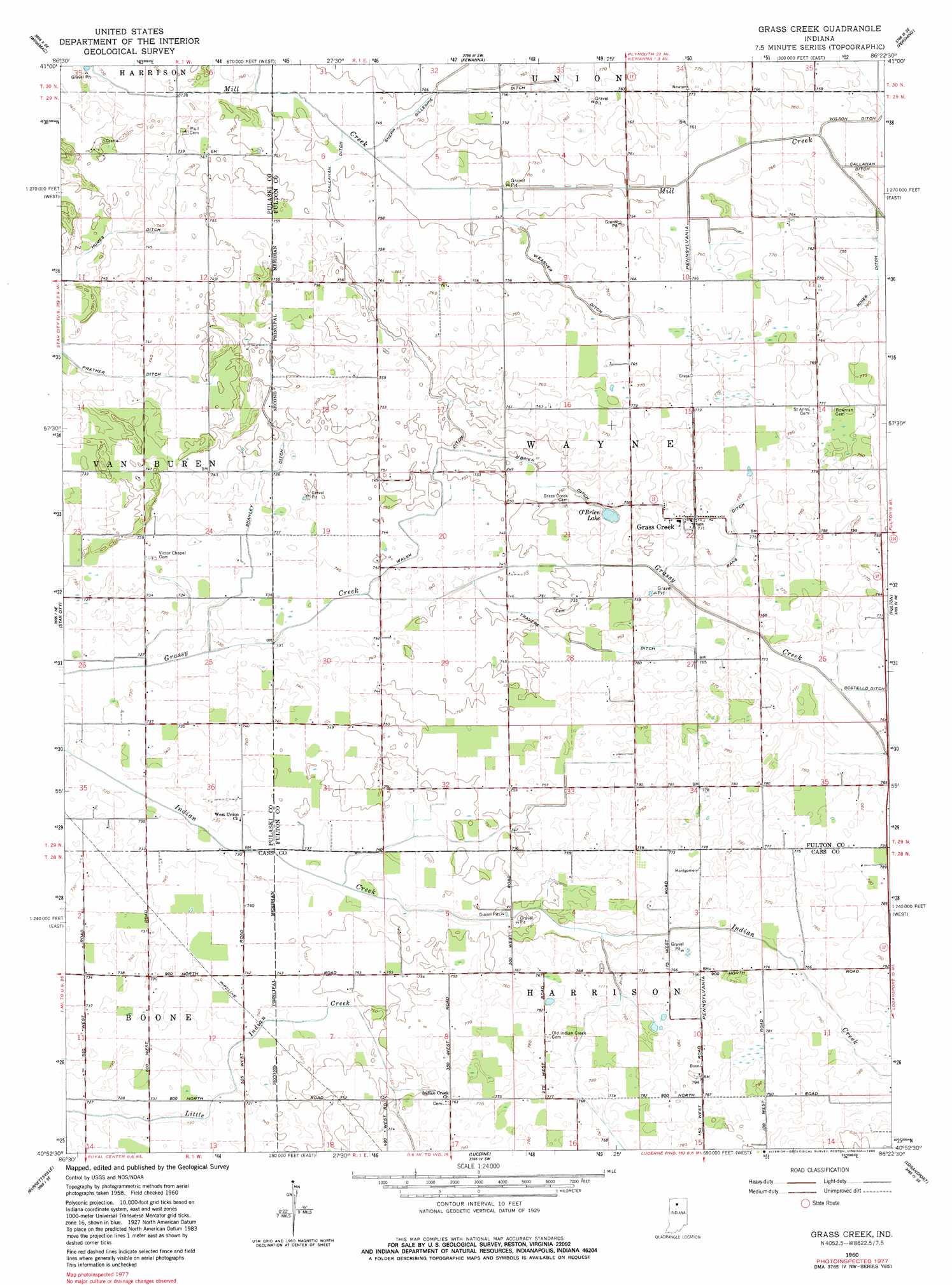
USGS Topo Quad 40086h4 - 1:24,000 scale
| Topo Map Name: | Grass Creek |
| USGS Topo Quad ID: | 40086h4 |
| Print Size: | ca. 21 1/4" wide x 27" high |
| Southeast Coordinates: | 40.875° N latitude / 86.375° W longitude |
| Map Center Coordinates: | 40.9375° N latitude / 86.4375° W longitude |
| U.S. State: | IN |
| Filename: | o40086h4.jpg |
| Download Map JPG Image: | Grass Creek topo map 1:24,000 scale |
| Map Type: | Topographic |
| Topo Series: | 7.5´ |
| Map Scale: | 1:24,000 |
| Source of Map Images: | United States Geological Survey (USGS) |
| Alternate Map Versions: |
Grass Creek IN 1960, updated 1964 Download PDF Buy paper map Grass Creek IN 1960, updated 1980 Download PDF Buy paper map Grass Creek IN 1960, updated 1980 Download PDF Buy paper map Grass Creek IN 2010 Download PDF Buy paper map Grass Creek IN 2013 Download PDF Buy paper map Grass Creek IN 2016 Download PDF Buy paper map |
1:24,000 Topo Quads surrounding Grass Creek
Denham |
Bass Lake |
Culver |
Rutland |
Argos |
Ripley |
Winamac |
Kewanna |
Pershing |
Rochester |
Buffalo |
Star City |
Grass Creek |
Fulton |
Macy |
Idaville |
Burnettsville |
Lucerne |
Logansport |
Twelve Mile |
Yeoman |
Burrows |
Clymers |
Anoka |
Onward |
> Back to 40086e1 at 1:100,000 scale
> Back to 40086a1 at 1:250,000 scale
> Back to U.S. Topo Maps home
Grass Creek topo map: Gazetteer
Grass Creek: Airports
Plummer Airport elevation 232m 761′Grass Creek: Canals
Hines Ditch elevation 231m 757′Humes Ditch elevation 225m 738′
O'Brien Ditch elevation 228m 748′
Shanley Ditch elevation 225m 738′
Travers Ditch elevation 230m 754′
Walsh Ditch elevation 229m 751′
Weasner Ditch elevation 230m 754′
Wilson Ditch elevation 230m 754′
Grass Creek: Lakes
O'Brien Lake elevation 228m 748′Grass Creek: Populated Places
Grass Creek elevation 235m 770′Grass Creek digital topo map on disk
Buy this Grass Creek topo map showing relief, roads, GPS coordinates and other geographical features, as a high-resolution digital map file on DVD:
Northern Illinois, Northern Indiana & Southwestern Michigan
Buy digital topo maps: Northern Illinois, Northern Indiana & Southwestern Michigan