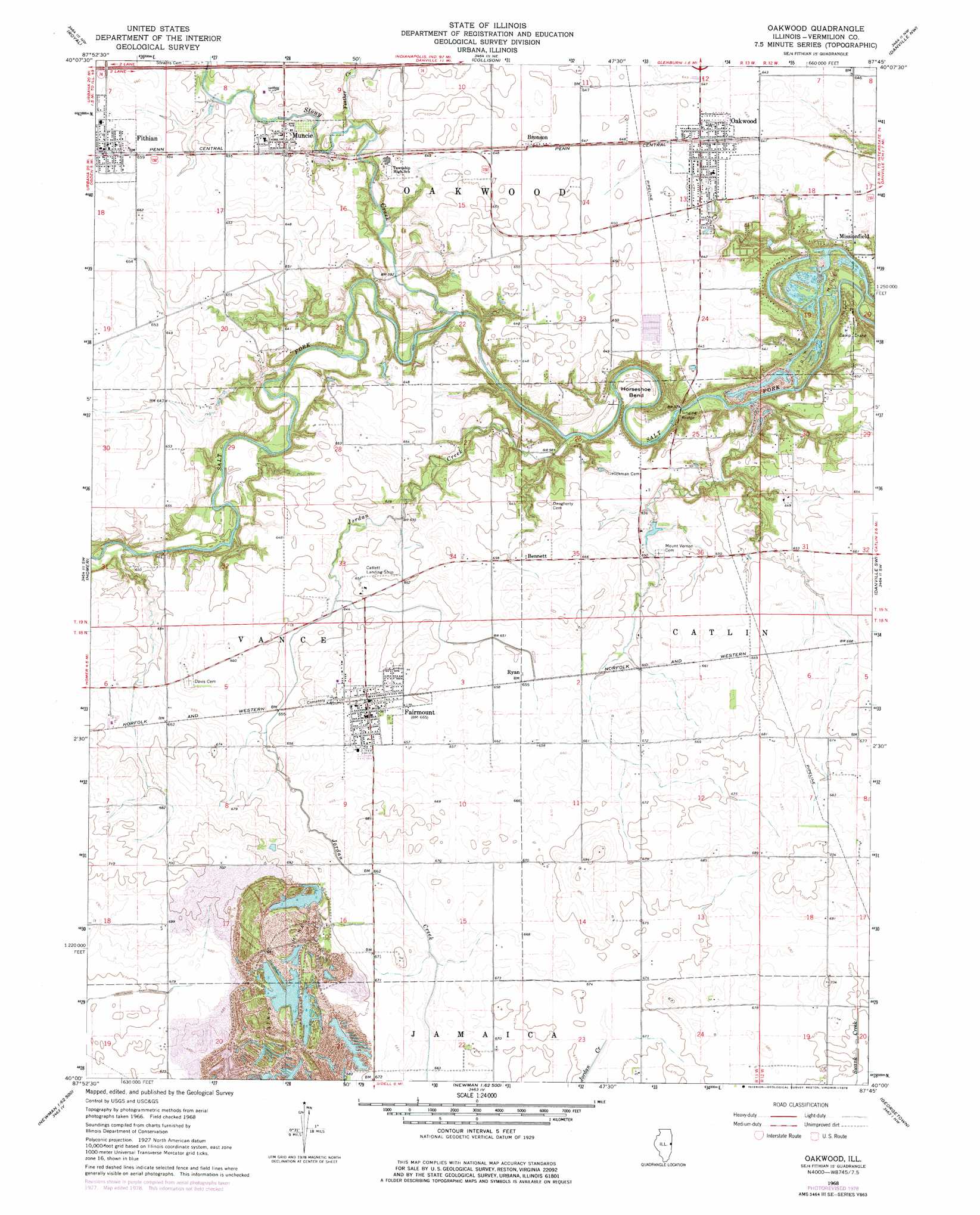
Oakwood Topo Map Illinois
To zoom in, hover over the map of Oakwood
USGS Topo Quad 40087a7 - 1:24,000 scale
| Topo Map Name: | Oakwood |
| USGS Topo Quad ID: | 40087a7 |
| Print Size: | ca. 21 1/4" wide x 27" high |
| Southeast Coordinates: | 40° N latitude / 87.75° W longitude |
| Map Center Coordinates: | 40.0625° N latitude / 87.8125° W longitude |
| U.S. State: | IL |
| Filename: | o40087a7.jpg |
| Download Map JPG Image: | Oakwood topo map 1:24,000 scale |
| Map Type: | Topographic |
| Topo Series: | 7.5´ |
| Map Scale: | 1:24,000 |
| Source of Map Images: | United States Geological Survey (USGS) |
| Alternate Map Versions: |
Oakwood IL 1968, updated 1969 Download PDF Buy paper map Oakwood IL 1968, updated 1978 Download PDF Buy paper map Oakwood IL 1968, updated 1978 Download PDF Buy paper map Oakwood IL 2012 Download PDF Buy paper map Oakwood IL 2015 Download PDF Buy paper map |
1:24,000 Topo Quads surrounding Oakwood
Gifford |
Penfield |
Potomac |
Henning |
Bismarck |
Flatville |
Royal |
Collison |
Danville Nw |
Danville Ne |
Saint Joseph |
Homer |
Oakwood |
Danville Sw |
Danville Se |
Longview |
Allerton |
Sidell |
Georgetown |
Humrick |
Murdock |
Newman |
Hume |
Chrisman |
Scottland |
> Back to 40087a1 at 1:100,000 scale
> Back to 40086a1 at 1:250,000 scale
> Back to U.S. Topo Maps home
Oakwood topo map: Gazetteer
Oakwood: Airports
Cast Airport elevation 204m 669′Catlett Landing Strip elevation 198m 649′
Oakwood: Bends
Horseshoe Bend elevation 176m 577′Oakwood: Bridges
Singing Bridge elevation 173m 567′Oakwood: Dams
Marvin Puzey Lake Dam elevation 197m 646′Oakwood: Populated Places
Bennett elevation 200m 656′Bronson elevation 198m 649′
Fairmount elevation 203m 666′
Fithian elevation 202m 662′
Missionfield elevation 195m 639′
Muncie elevation 197m 646′
Oakwood elevation 197m 646′
Ryan elevation 199m 652′
Oakwood: Post Offices
Fairmount Post Office elevation 202m 662′Fithian Post Office elevation 202m 662′
Oakwood Post Office elevation 197m 646′
Oakwood: Reservoirs
Marvin Puzey Lake elevation 197m 646′Oakwood: Streams
Feather Creek elevation 185m 606′Jordan Creek elevation 202m 662′
Stony Creek elevation 174m 570′
Oakwood digital topo map on disk
Buy this Oakwood topo map showing relief, roads, GPS coordinates and other geographical features, as a high-resolution digital map file on DVD:
Northern Illinois, Northern Indiana & Southwestern Michigan
Buy digital topo maps: Northern Illinois, Northern Indiana & Southwestern Michigan