Goodland Topo Map Indiana
To zoom in, hover over the map of Goodland
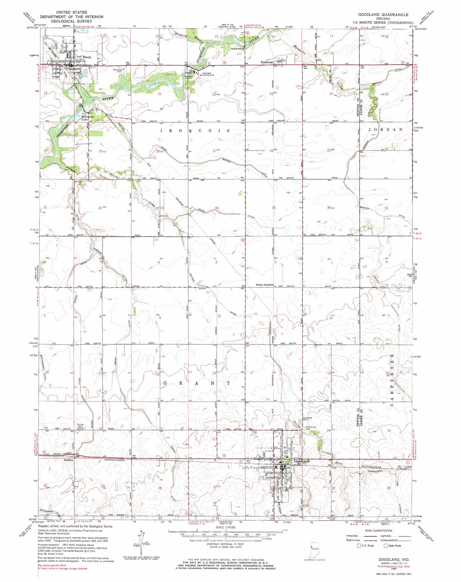
USGS Topo Quad 40087g3 - 1:24,000 scale
| Topo Map Name: | Goodland |
| USGS Topo Quad ID: | 40087g3 |
| Print Size: | ca. 21 1/4" wide x 27" high |
| Southeast Coordinates: | 40.75° N latitude / 87.25° W longitude |
| Map Center Coordinates: | 40.8125° N latitude / 87.3125° W longitude |
| U.S. State: | IN |
| Filename: | o40087g3.jpg |
| Download Map JPG Image: | Goodland topo map 1:24,000 scale |
| Map Type: | Topographic |
| Topo Series: | 7.5´ |
| Map Scale: | 1:24,000 |
| Source of Map Images: | United States Geological Survey (USGS) |
| Alternate Map Versions: |
Goodland IN 1962, updated 1964 Download PDF Buy paper map Goodland IN 1962, updated 1976 Download PDF Buy paper map Goodland IN 2010 Download PDF Buy paper map Goodland IN 2013 Download PDF Buy paper map Goodland IN 2016 Download PDF Buy paper map |
1:24,000 Topo Quads surrounding Goodland
Leesville |
Enos |
Fair Oaks |
Parr |
Gifford |
Donovan |
Morocco |
Mount Ayr |
Rensselaer |
Mccoysburg |
Sheldon |
Kentland |
Goodland |
Remington |
Wolcott |
Darrow |
Earl Park |
Wadena |
Mount Gilboa |
Templeton Ne |
Stockland |
Boswell |
Fowler |
Templeton |
Round Grove |
> Back to 40087e1 at 1:100,000 scale
> Back to 40086a1 at 1:250,000 scale
> Back to U.S. Topo Maps home
Goodland topo map: Gazetteer
Goodland: Canals
Barten Ditch elevation 199m 652′Bower Ditch elevation 204m 669′
Darroch Ditch elevation 196m 643′
Hunter Ditch elevation 207m 679′
Hunter Ditch elevation 204m 669′
Jones Ditch elevation 199m 652′
Moran Ditch elevation 204m 669′
O'Brien Ditch elevation 208m 682′
Stack Ditch elevation 203m 666′
Weiss Ditch elevation 200m 656′
Goodland: Lakes
Riverside Lake elevation 197m 646′Goodland: Parks
Foster Park elevation 219m 718′Goodland: Populated Places
Brook elevation 199m 652′Foresman elevation 199m 652′
Goodland elevation 221m 725′
Percy Junction elevation 204m 669′
Perkins elevation 209m 685′
Goodland: Streams
Hickory Branch elevation 196m 643′Mosquito Creek elevation 194m 636′
Goodland digital topo map on disk
Buy this Goodland topo map showing relief, roads, GPS coordinates and other geographical features, as a high-resolution digital map file on DVD:
Northern Illinois, Northern Indiana & Southwestern Michigan
Buy digital topo maps: Northern Illinois, Northern Indiana & Southwestern Michigan