Bondville Topo Map Illinois
To zoom in, hover over the map of Bondville
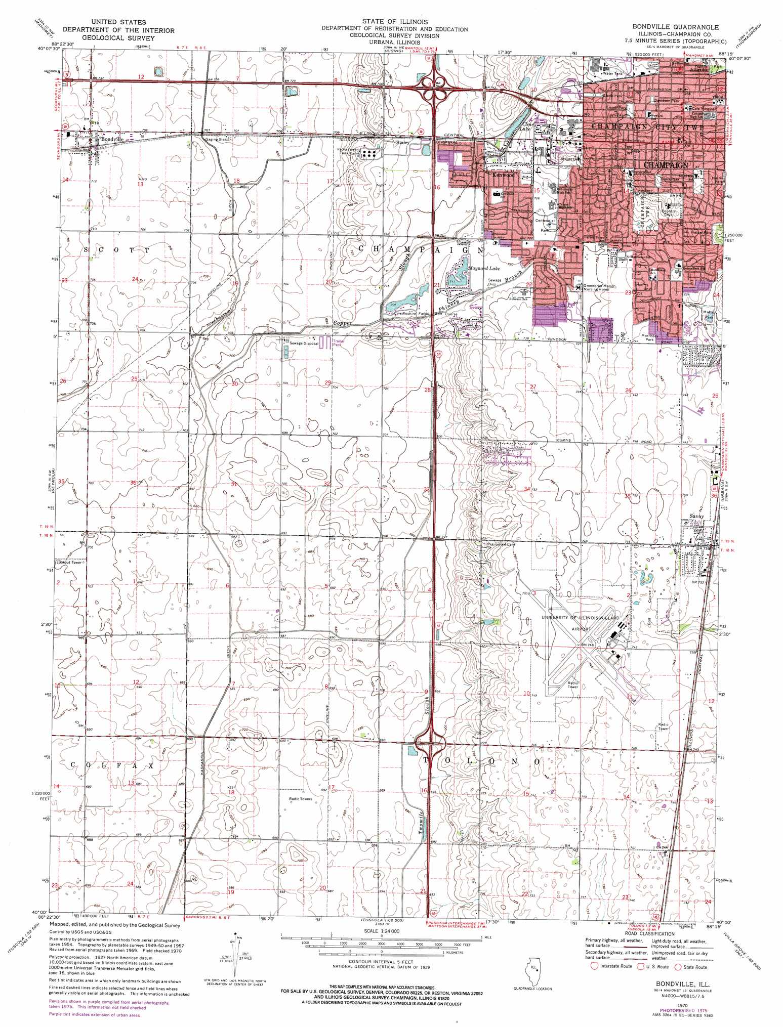
USGS Topo Quad 40088a3 - 1:24,000 scale
| Topo Map Name: | Bondville |
| USGS Topo Quad ID: | 40088a3 |
| Print Size: | ca. 21 1/4" wide x 27" high |
| Southeast Coordinates: | 40° N latitude / 88.25° W longitude |
| Map Center Coordinates: | 40.0625° N latitude / 88.3125° W longitude |
| U.S. State: | IL |
| Filename: | o40088a3.jpg |
| Download Map JPG Image: | Bondville topo map 1:24,000 scale |
| Map Type: | Topographic |
| Topo Series: | 7.5´ |
| Map Scale: | 1:24,000 |
| Source of Map Images: | United States Geological Survey (USGS) |
| Alternate Map Versions: |
Bondville IL 1957, updated 1958 Download PDF Buy paper map Bondville IL 1970, updated 1972 Download PDF Buy paper map Bondville IL 1970, updated 1976 Download PDF Buy paper map Bondville IL 1975, updated 1976 Download PDF Buy paper map Bondville IL 1998, updated 2001 Download PDF Buy paper map Bondville IL 2012 Download PDF Buy paper map Bondville IL 2015 Download PDF Buy paper map |
1:24,000 Topo Quads surrounding Bondville
Belleflower |
Foosland |
Fisher |
Rantoul |
Gifford |
Mansfield |
Mahomet |
Rising |
Thomasboro |
Flatville |
Monticello |
Seymour |
Bondville |
Urbana |
Saint Joseph |
Bement |
Ivesdale |
Tolono |
Villa Grove Nw |
Longview |
Hammond |
Atwood |
Tuscola |
Villa Grove |
Murdock |
> Back to 40088a1 at 1:100,000 scale
> Back to 40088a1 at 1:250,000 scale
> Back to U.S. Topo Maps home
Bondville topo map: Gazetteer
Bondville: Airports
University of Illinois-Willard Airport elevation 228m 748′Bondville: Crossings
Interchange 229 elevation 212m 695′Interchange 235 elevation 228m 748′
Interchange 79 elevation 228m 748′
Bondville: Lakes
Clear Lake elevation 221m 725′Maynard Lake elevation 217m 711′
Bondville: Parks
Centennial Park elevation 221m 725′Clark Park elevation 238m 780′
Davidson Park elevation 233m 764′
Eisner Park elevation 234m 767′
Glenn Park elevation 228m 748′
Harris Park elevation 229m 751′
Heritage Park elevation 222m 728′
Hessel Park elevation 228m 748′
Johnson Park elevation 222m 728′
Kaufman Park elevation 221m 725′
Mattis Park elevation 220m 721′
Mayfair Park elevation 225m 738′
Morrissey Park elevation 226m 741′
Robeson Park elevation 216m 708′
Spalding Park elevation 228m 748′
Willis Park elevation 231m 757′
Wisegarver Park elevation 221m 725′
Bondville: Populated Places
Bondville elevation 219m 718′Kenwood elevation 221m 725′
Savoy elevation 224m 734′
Staley elevation 226m 741′
Bondville: Reservoirs
Mattis Lake elevation 220m 721′Bondville: Streams
Copper Slough elevation 208m 682′Phinney Branch elevation 213m 698′
Bondville digital topo map on disk
Buy this Bondville topo map showing relief, roads, GPS coordinates and other geographical features, as a high-resolution digital map file on DVD:
Northern Illinois, Northern Indiana & Southwestern Michigan
Buy digital topo maps: Northern Illinois, Northern Indiana & Southwestern Michigan