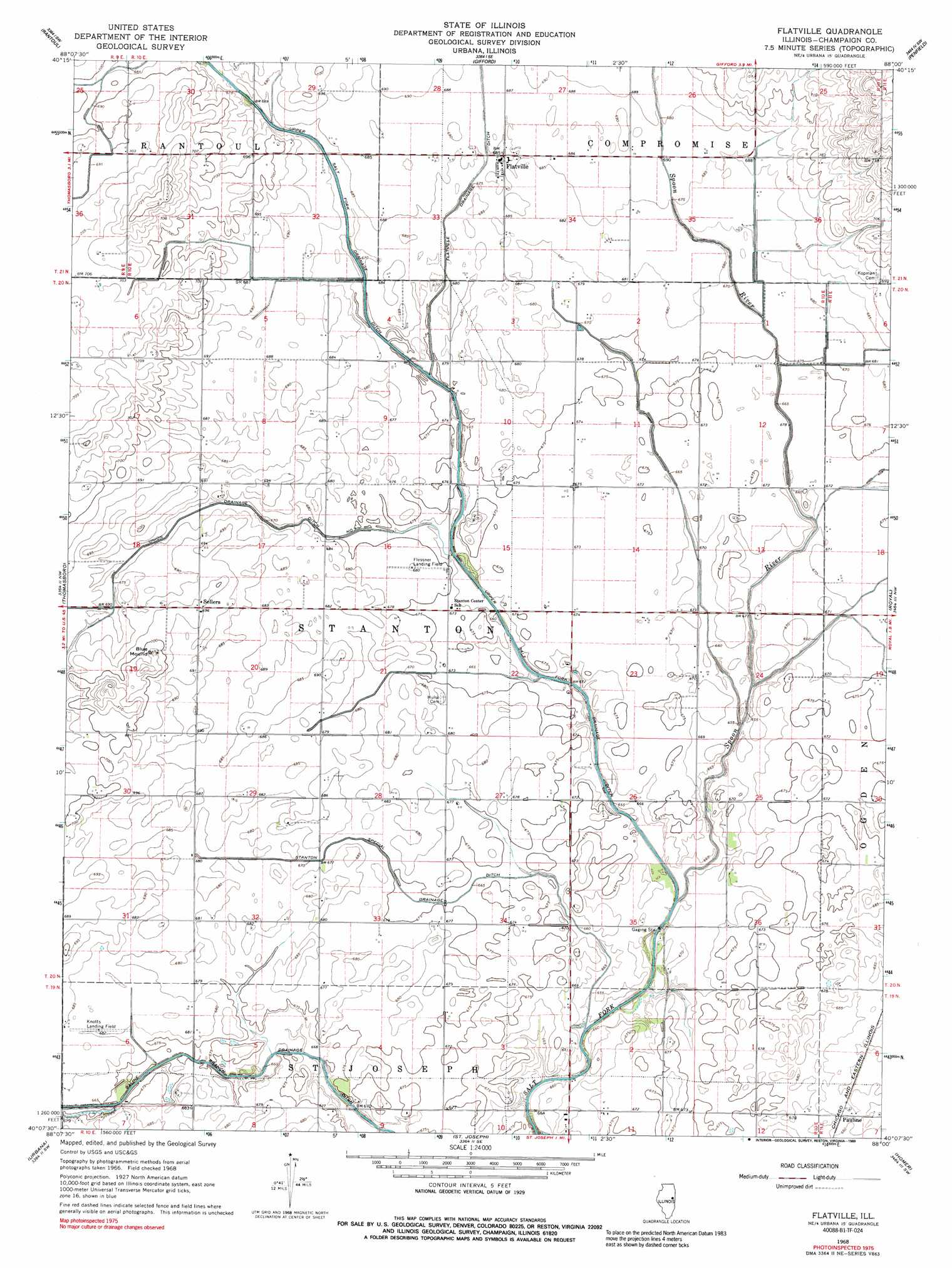
Flatville Topo Map Illinois
To zoom in, hover over the map of Flatville
USGS Topo Quad 40088b1 - 1:24,000 scale
| Topo Map Name: | Flatville |
| USGS Topo Quad ID: | 40088b1 |
| Print Size: | ca. 21 1/4" wide x 27" high |
| Southeast Coordinates: | 40.125° N latitude / 88° W longitude |
| Map Center Coordinates: | 40.1875° N latitude / 88.0625° W longitude |
| U.S. State: | IL |
| Filename: | o40088b1.jpg |
| Download Map JPG Image: | Flatville topo map 1:24,000 scale |
| Map Type: | Topographic |
| Topo Series: | 7.5´ |
| Map Scale: | 1:24,000 |
| Source of Map Images: | United States Geological Survey (USGS) |
| Alternate Map Versions: |
Flatville IL 1968, updated 1970 Download PDF Buy paper map Flatville IL 1968, updated 1989 Download PDF Buy paper map Flatville IL 2012 Download PDF Buy paper map Flatville IL 2015 Download PDF Buy paper map |
1:24,000 Topo Quads surrounding Flatville
Gibson City East |
Perdueville |
Paxton |
Rankin |
East Lynn |
Fisher |
Rantoul |
Gifford |
Penfield |
Potomac |
Rising |
Thomasboro |
Flatville |
Royal |
Collison |
Bondville |
Urbana |
Saint Joseph |
Homer |
Oakwood |
Tolono |
Villa Grove Nw |
Longview |
Allerton |
Sidell |
> Back to 40088a1 at 1:100,000 scale
> Back to 40088a1 at 1:250,000 scale
> Back to U.S. Topo Maps home
Flatville topo map: Gazetteer
Flatville: Airports
Flessner Landing Field elevation 207m 679′Knott Airport elevation 208m 682′
Schmidt Airport elevation 209m 685′
Flatville: Canals
Stanton Special Drainage Ditch elevation 203m 666′Union Drainage Ditch Number 1 elevation 207m 679′
Upper Salt Fork Drainage Ditch elevation 206m 675′
Flatville: Populated Places
Flatville elevation 209m 685′Pauline elevation 209m 685′
Sellers elevation 212m 695′
Flatville: Streams
Spoon River elevation 198m 649′Flatville: Summits
Blue Mound elevation 214m 702′Flatville digital topo map on disk
Buy this Flatville topo map showing relief, roads, GPS coordinates and other geographical features, as a high-resolution digital map file on DVD:
Northern Illinois, Northern Indiana & Southwestern Michigan
Buy digital topo maps: Northern Illinois, Northern Indiana & Southwestern Michigan