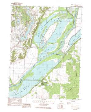
Duck Island Topo Map Illinois
To zoom in, hover over the map of Duck Island
USGS Topo Quad 40089d8 - 1:24,000 scale
| Topo Map Name: | Duck Island |
| USGS Topo Quad ID: | 40089d8 |
| Print Size: | ca. 21 1/4" wide x 27" high |
| Southeast Coordinates: | 40.375° N latitude / 89.875° W longitude |
| Map Center Coordinates: | 40.4375° N latitude / 89.9375° W longitude |
| U.S. State: | IL |
| Filename: | o40089d8.jpg |
| Download Map JPG Image: | Duck Island topo map 1:24,000 scale |
| Map Type: | Topographic |
| Topo Series: | 7.5´ |
| Map Scale: | 1:24,000 |
| Source of Map Images: | United States Geological Survey (USGS) |
| Alternate Map Versions: |
Duck Island IL 1982, updated 1982 Download PDF Buy paper map Duck Island IL 1996, updated 1997 Download PDF Buy paper map Duck Island IL 2012 Download PDF Buy paper map Duck Island IL 2015 Download PDF Buy paper map |
1:24,000 Topo Quads surrounding Duck Island
> Back to 40089a1 at 1:100,000 scale
> Back to 40088a1 at 1:250,000 scale
> Back to U.S. Topo Maps home
Duck Island topo map: Gazetteer
Duck Island: Airports
Shissler Seed Company Incorporated Airport elevation 152m 498′Duck Island: Channels
The Narrows elevation 136m 446′Duck Island: Dams
Copperas Creek Dam elevation 136m 446′Duck Creek Reservoir Dam elevation 172m 564′
Duck Island: Flats
Barton Field elevation 136m 446′Duck Island: Guts
Buckbrush Slough elevation 136m 446′Goose Slough elevation 136m 446′
West River elevation 136m 446′
Woodyard Slough elevation 136m 446′
Duck Island: Islands
Duck Island elevation 139m 456′Mink Island elevation 136m 446′
Miserable Island elevation 136m 446′
Senate Island elevation 136m 446′
Sturgeon Island elevation 136m 446′
Duck Island: Lakes
Beebe Lake elevation 136m 446′Big Lake elevation 136m 446′
Clear Lake elevation 136m 446′
Goose Lake elevation 136m 446′
Liverpool Lake elevation 135m 442′
Lock Pond elevation 135m 442′
Lost Lake elevation 136m 446′
Miserable Lake elevation 136m 446′
Mud Lake elevation 136m 446′
Pond Lily Lake elevation 136m 446′
Pond Lily Lake elevation 136m 446′
Rice Lake elevation 136m 446′
Slim Lake elevation 136m 446′
Duck Island: Parks
Copperas Creek Management Area elevation 136m 446′Henry Allan Gleason Nature Preserve elevation 155m 508′
Rice Lake State Conservation Area elevation 136m 446′
Duck Island: Populated Places
Goofy Ridge elevation 147m 482′Duck Island: Reservoirs
Duck Creek Cooling Pond elevation 172m 564′Duck Island: Ridges
Hoxie Ridge elevation 136m 446′Duck Island: Streams
Buckheart Creek elevation 135m 442′Copperas Creek elevation 136m 446′
Duck Creek elevation 136m 446′
Duck Island: Trails
Deer Run Hiking Trail elevation 162m 531′Duck Island digital topo map on disk
Buy this Duck Island topo map showing relief, roads, GPS coordinates and other geographical features, as a high-resolution digital map file on DVD:
Northern Illinois, Northern Indiana & Southwestern Michigan
Buy digital topo maps: Northern Illinois, Northern Indiana & Southwestern Michigan


