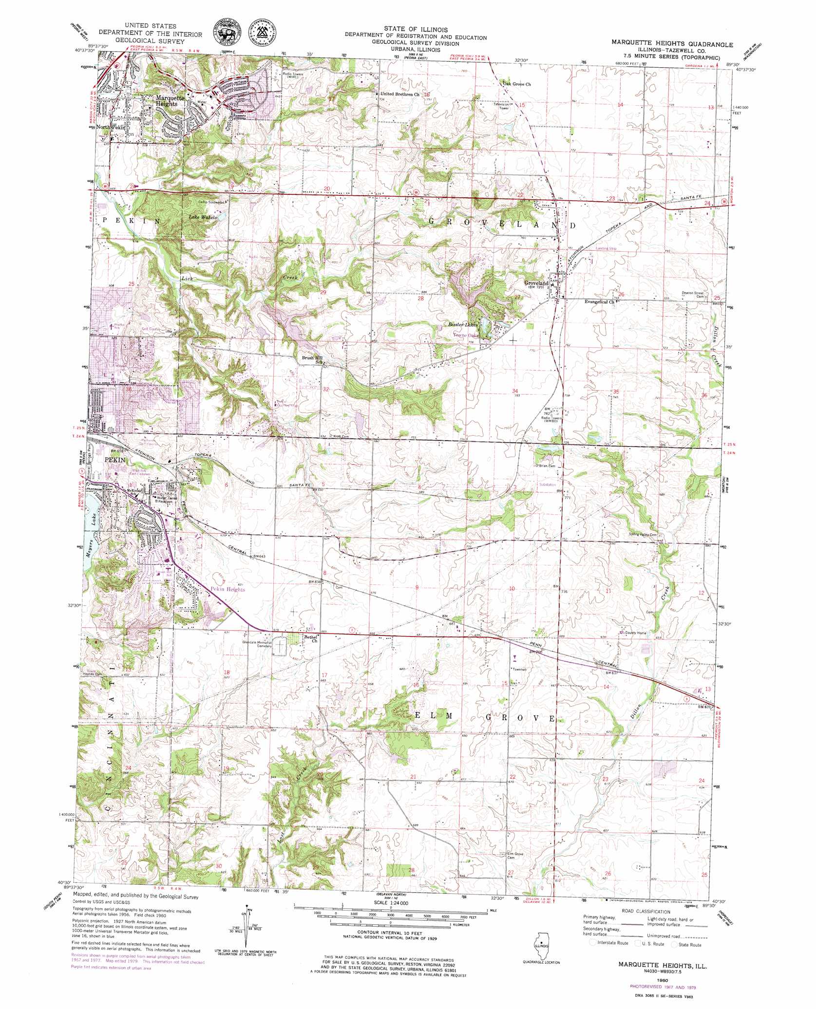
Marquette Heights Topo Map Illinois
To zoom in, hover over the map of Marquette Heights
USGS Topo Quad 40089e5 - 1:24,000 scale
| Topo Map Name: | Marquette Heights |
| USGS Topo Quad ID: | 40089e5 |
| Print Size: | ca. 21 1/4" wide x 27" high |
| Southeast Coordinates: | 40.5° N latitude / 89.5° W longitude |
| Map Center Coordinates: | 40.5625° N latitude / 89.5625° W longitude |
| U.S. State: | IL |
| Filename: | o40089e5.jpg |
| Download Map JPG Image: | Marquette Heights topo map 1:24,000 scale |
| Map Type: | Topographic |
| Topo Series: | 7.5´ |
| Map Scale: | 1:24,000 |
| Source of Map Images: | United States Geological Survey (USGS) |
| Alternate Map Versions: |
Marquette Heights IL 1960, updated 1961 Download PDF Buy paper map Marquette Heights IL 1960, updated 1968 Download PDF Buy paper map Marquette Heights IL 1960, updated 1979 Download PDF Buy paper map Marquette Heights IL 1996, updated 1997 Download PDF Buy paper map Marquette Heights IL 2012 Download PDF Buy paper map Marquette Heights IL 2015 Download PDF Buy paper map |
1:24,000 Topo Quads surrounding Marquette Heights
Oak Hill |
Dunlap |
Spring Bay |
Germantown Hills |
Metamora |
Hanna City |
Peoria West |
Peoria East |
Washington |
Eureka |
Glasford |
Pekin |
Marquette Heights |
Morton |
Mackinaw |
Manito |
South Pekin |
Delavan North |
Hopedale |
Minier |
Forest City |
Natrona |
Delavan South |
Emden |
Armington |
> Back to 40089e1 at 1:100,000 scale
> Back to 40088a1 at 1:250,000 scale
> Back to U.S. Topo Maps home
Marquette Heights topo map: Gazetteer
Marquette Heights: Dams
Bessler Lake Dam elevation 225m 738′Birkey Lake Dam elevation 191m 626′
Grand Oaks Lake Dam elevation 216m 708′
Home Lake Dam elevation 161m 528′
Lake of the Whispering Oaks Dam elevation 216m 708′
Lake Wildwood Dam elevation 208m 682′
Lutticken Lake Dam elevation 181m 593′
Lutticken South Pond Dam elevation 183m 600′
Northern Oaks Lake Dam elevation 220m 721′
Sunset Hills Dam Number 1 elevation 177m 580′
Sunset Hills Dam Number 2 elevation 180m 590′
Sunset Hills Golf Course Lake Dam elevation 182m 597′
Waheld Pond Dam elevation 187m 613′
Marquette Heights: Lakes
Bessler Lakes elevation 222m 728′Lake Wahelo elevation 183m 600′
Meyers Lake elevation 158m 518′
Marquette Heights: Parks
Everett Dirksen Park elevation 182m 597′John T McNaughton Park elevation 151m 495′
Marquette Heights: Populated Places
Groveland elevation 235m 770′Marquette Heights elevation 189m 620′
North Pekin elevation 147m 482′
Pekin Heights elevation 196m 643′
Towne Oaks elevation 229m 751′
Marquette Heights: Reservoirs
Bessler Lake elevation 225m 738′Birkey Lake elevation 191m 626′
Grand Oaks Lake elevation 216m 708′
Home Lake elevation 161m 528′
Lake of the Whispering Oaks elevation 216m 708′
Lake Wildwood elevation 208m 682′
Lutticken Lake elevation 181m 593′
Lutticken South Pond elevation 183m 600′
Northern Oaks Lake elevation 220m 721′
Sunset Hills Golf Course Lake elevation 182m 597′
Sunset Hills Lake Number 1 elevation 177m 580′
Sunset Hills Lake Number 2 elevation 180m 590′
Waheld Pond elevation 187m 613′
Marquette Heights digital topo map on disk
Buy this Marquette Heights topo map showing relief, roads, GPS coordinates and other geographical features, as a high-resolution digital map file on DVD:
Northern Illinois, Northern Indiana & Southwestern Michigan
Buy digital topo maps: Northern Illinois, Northern Indiana & Southwestern Michigan