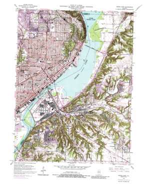
Peoria East Topo Map Illinois
To zoom in, hover over the map of Peoria East
USGS Topo Quad 40089f5 - 1:24,000 scale
| Topo Map Name: | Peoria East |
| USGS Topo Quad ID: | 40089f5 |
| Print Size: | ca. 21 1/4" wide x 27" high |
| Southeast Coordinates: | 40.625° N latitude / 89.5° W longitude |
| Map Center Coordinates: | 40.6875° N latitude / 89.5625° W longitude |
| U.S. State: | IL |
| Filename: | o40089f5.jpg |
| Download Map JPG Image: | Peoria East topo map 1:24,000 scale |
| Map Type: | Topographic |
| Topo Series: | 7.5´ |
| Map Scale: | 1:24,000 |
| Source of Map Images: | United States Geological Survey (USGS) |
| Alternate Map Versions: |
Peoria East IL 1949, updated 1966 Download PDF Buy paper map Peoria East IL 1949, updated 1968 Download PDF Buy paper map Peoria East IL 1949, updated 1976 Download PDF Buy paper map Peoria East IL 1949, updated 1979 Download PDF Buy paper map Peoria East IL 1949, updated 1987 Download PDF Buy paper map Peoria East IL 1950 Download PDF Buy paper map Peoria East IL 1996, updated 1997 Download PDF Buy paper map Peoria East IL 2012 Download PDF Buy paper map Peoria East IL 2015 Download PDF Buy paper map |
1:24,000 Topo Quads surrounding Peoria East
> Back to 40089e1 at 1:100,000 scale
> Back to 40088a1 at 1:250,000 scale
> Back to U.S. Topo Maps home
Peoria East topo map: Gazetteer
Peoria East: Airports
Cilco Peoria Downtown Heliport elevation 139m 456′Methodist Medical Center of Illinois Heliport elevation 173m 567′
Saint Francis Hospital Heliport elevation 176m 577′
Peoria East: Bridges
Bob Michel Bridge elevation 136m 446′Cedar Street Bridge elevation 136m 446′
McClugage Bridge elevation 136m 446′
Murray M Baker Bridge elevation 136m 446′
Shade-Lohman Bridge elevation 136m 446′
Peoria East: Crossings
Interchange 15 elevation 219m 718′Interchange 89 elevation 193m 633′
Interchange 9 elevation 153m 501′
Interchange 90 elevation 170m 557′
Interchange 91 elevation 166m 544′
Interchange 92 elevation 174m 570′
Interchange 93 elevation 143m 469′
Interchange 94 elevation 141m 462′
Interchange 95 elevation 145m 475′
Interchange 96 elevation 145m 475′
Interchange 98 elevation 217m 711′
Interchange 99 elevation 219m 718′
Peoria East: Dams
Farm Creek Dams elevation 170m 557′Farmdale Dam elevation 171m 561′
Fondulac Dam elevation 173m 567′
Mulvaney Pond Dam elevation 233m 764′
Peoria East: Lakes
Peoria Lake elevation 136m 446′Peoria East: Parks
Bennetts Terraqueous Gardens Nature Preserve elevation 146m 479′Bradley Park (historical) elevation 164m 538′
Brady Park elevation 199m 652′
Carver Recreational Center elevation 157m 515′
Cooper Park elevation 137m 449′
Courthouse Square elevation 153m 501′
Crevecoeur Nature Preserve elevation 158m 518′
East Peoria Pool and Recreation Area elevation 177m 580′
Fondulac Park elevation 186m 610′
Fort Creve Coeur State Park elevation 171m 561′
Glen Oak Park elevation 192m 629′
Glen Oak Zoo elevation 198m 649′
Grand View Park elevation 190m 623′
Hillside Park elevation 202m 662′
Lakeview Park elevation 206m 675′
Lakeview Park elevation 208m 682′
Liberty Park elevation 138m 452′
Lincoln Park elevation 156m 511′
McGlothlin Farm Park and Petting Zoo elevation 201m 659′
Morton Park elevation 155m 508′
Peoria Stadium elevation 206m 675′
Richland Park elevation 134m 439′
Roanoke-Randolph Street Historic District elevation 186m 610′
Shea Stadium elevation 181m 593′
Terrace Park elevation 169m 554′
Waterworks Park elevation 136m 446′
Woods Park elevation 233m 764′
Peoria East: Populated Places
Averyville elevation 158m 518′Caldwell elevation 213m 698′
Cloverdale elevation 217m 711′
Creve Coeur elevation 209m 685′
East Peoria elevation 140m 459′
Farmdale elevation 165m 541′
Fond du Lac elevation 140m 459′
Fondulac Plaza Shopping Center elevation 155m 508′
Gardena elevation 216m 708′
Highway Village elevation 151m 495′
North Peoria elevation 193m 633′
Peoria elevation 152m 498′
Peoria Heights elevation 239m 784′
Robein elevation 208m 682′
Sunnyland elevation 208m 682′
Trailpark Gardens elevation 148m 485′
Wesley elevation 141m 462′
Peoria East: Post Offices
East Peoria Post Office elevation 140m 459′Peoria Post Office elevation 156m 511′
Peoria East: Reservoirs
Farmdale Reservoir elevation 171m 561′Fondulac Reservoir elevation 173m 567′
Mulvaney Pond elevation 233m 764′
Peoria Heights Reservoir elevation 220m 721′
Peoria East: Springs
Peoria Mineral Springs elevation 165m 541′Peoria East: Streams
Ackerman Creek elevation 161m 528′Coal Creek elevation 137m 449′
Farm Creek elevation 136m 446′
Kickapoo Creek elevation 136m 446′
Spring Creek elevation 143m 469′
Tenmile Creek elevation 136m 446′
Peoria East digital topo map on disk
Buy this Peoria East topo map showing relief, roads, GPS coordinates and other geographical features, as a high-resolution digital map file on DVD:
Northern Illinois, Northern Indiana & Southwestern Michigan
Buy digital topo maps: Northern Illinois, Northern Indiana & Southwestern Michigan


