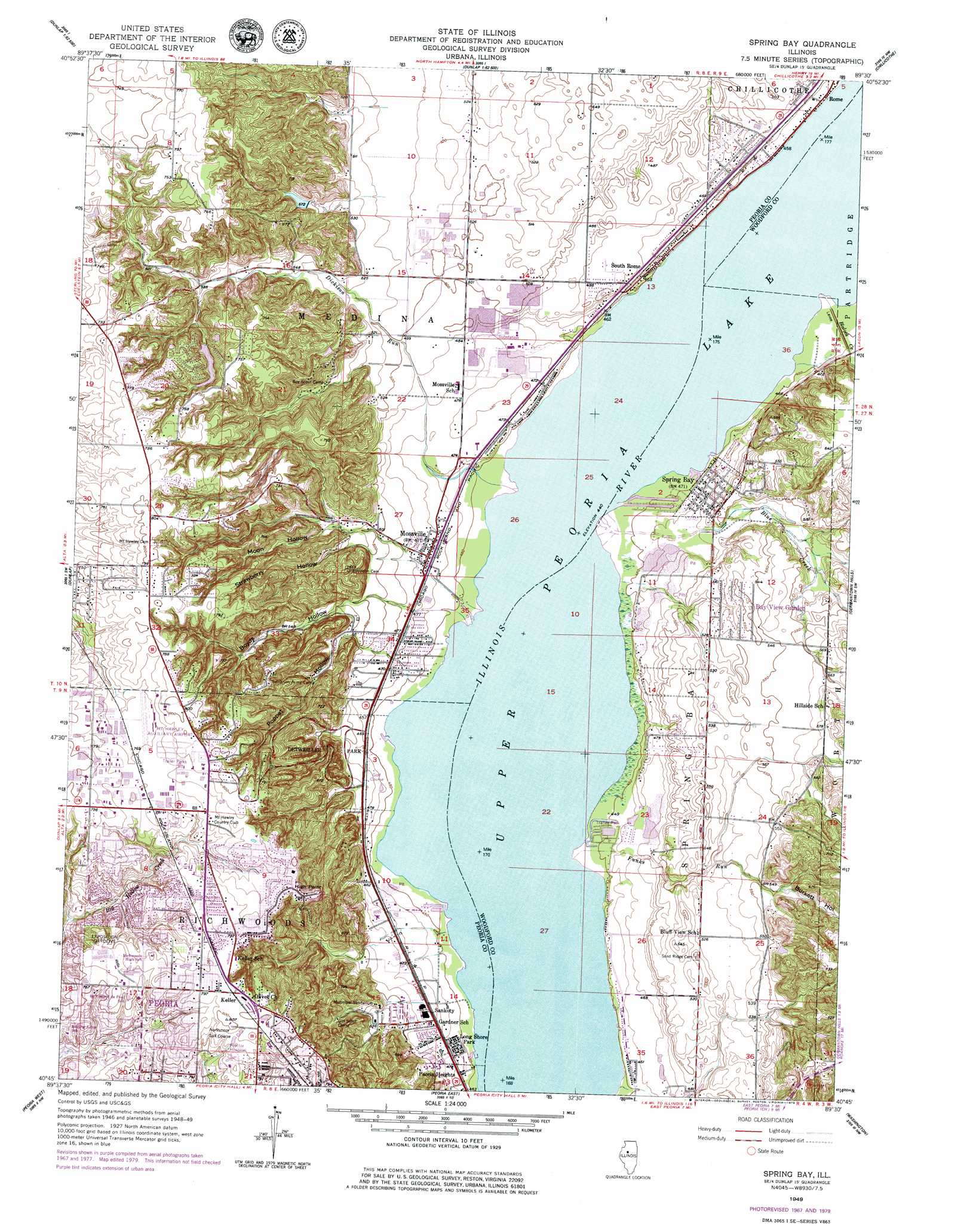
Spring Bay Topo Map Illinois
To zoom in, hover over the map of Spring Bay
USGS Topo Quad 40089g5 - 1:24,000 scale
| Topo Map Name: | Spring Bay |
| USGS Topo Quad ID: | 40089g5 |
| Print Size: | ca. 21 1/4" wide x 27" high |
| Southeast Coordinates: | 40.75° N latitude / 89.5° W longitude |
| Map Center Coordinates: | 40.8125° N latitude / 89.5625° W longitude |
| U.S. State: | IL |
| Filename: | o40089g5.jpg |
| Download Map JPG Image: | Spring Bay topo map 1:24,000 scale |
| Map Type: | Topographic |
| Topo Series: | 7.5´ |
| Map Scale: | 1:24,000 |
| Source of Map Images: | United States Geological Survey (USGS) |
| Alternate Map Versions: |
Spring Bay IL 1949, updated 1979 Download PDF Buy paper map Spring Bay IL 1950 Download PDF Buy paper map Spring Bay IL 1950, updated 1968 Download PDF Buy paper map Spring Bay IL 1996, updated 1997 Download PDF Buy paper map Spring Bay IL 2012 Download PDF Buy paper map Spring Bay IL 2015 Download PDF Buy paper map |
1:24,000 Topo Quads surrounding Spring Bay
Wyoming |
Castleton |
La Prairie Center |
Lacon |
Henry |
Princeville |
Edelstein |
Rome |
Chillicothe |
Washburn |
Oak Hill |
Dunlap |
Spring Bay |
Germantown Hills |
Metamora |
Hanna City |
Peoria West |
Peoria East |
Washington |
Eureka |
Glasford |
Pekin |
Marquette Heights |
Morton |
Mackinaw |
> Back to 40089e1 at 1:100,000 scale
> Back to 40088a1 at 1:250,000 scale
> Back to U.S. Topo Maps home
Spring Bay topo map: Gazetteer
Spring Bay: Airports
Exposition Gardens Heliport elevation 231m 757′Jerry E Staab Airport elevation 171m 561′
Mount Hawley Auxiliary Airport elevation 233m 764′
Proctor Community Hospital Heliport elevation 226m 741′
Spring Bay: Cliffs
High Point elevation 247m 810′Spring Bay: Dams
Lake of the Woods Dam elevation 205m 672′Spring Bay: Lakes
Upper Peoria Lake elevation 136m 446′Spring Bay: Parks
Bielfeldt Park elevation 162m 531′Detweiller Park elevation 185m 606′
Detweiller Woods Nature Preserve elevation 196m 643′
Forest Park Nature Center elevation 209m 685′
Forest Park Nature Preserve elevation 211m 692′
Forest Park South Nature Preserve elevation 217m 711′
Gaylord Wildlife Area elevation 137m 449′
Hickory Grove Park elevation 225m 738′
Illinois River State Fish and Wildlife Area elevation 136m 446′
Lindbergh Park elevation 228m 748′
Mount Hawley Park elevation 228m 748′
Prospect Park elevation 196m 643′
Robert Rutherford Wildlife Sanctuary elevation 136m 446′
Robinson Park elevation 181m 593′
Robinson Park Hill Prairies Nature Preserve elevation 181m 593′
Singing Woods Nature Preserve elevation 192m 629′
Spring Bay Fen Nature Preserve elevation 137m 449′
Woodford County State Conservation Area elevation 136m 446′
Woods Park elevation 212m 695′
Spring Bay: Populated Places
Bay View Garden elevation 162m 531′Cedar Bluff Estates elevation 236m 774′
Keller elevation 242m 793′
Long Shore Park elevation 138m 452′
Mossville elevation 142m 465′
Sankoty elevation 144m 472′
South Rome elevation 146m 479′
Spring Bay elevation 143m 469′
Spring Bay: Post Offices
Mossville Post Office elevation 143m 469′Peoria Post Office elevation 237m 777′
Spring Bay: Reservoirs
Lake of the Woods elevation 205m 672′Spring Bay: Streams
Blalock Creek elevation 136m 446′Blue Creek elevation 136m 446′
Dickison Run elevation 136m 446′
Funks Run elevation 136m 446′
Spring Bay: Valleys
Boyds Hollow elevation 156m 511′Burkett Hollow elevation 171m 561′
Moon Hollow elevation 171m 561′
Poppet Hollow elevation 153m 501′
Strawberry Hollow elevation 159m 521′
Spring Bay digital topo map on disk
Buy this Spring Bay topo map showing relief, roads, GPS coordinates and other geographical features, as a high-resolution digital map file on DVD:
Northern Illinois, Northern Indiana & Southwestern Michigan
Buy digital topo maps: Northern Illinois, Northern Indiana & Southwestern Michigan