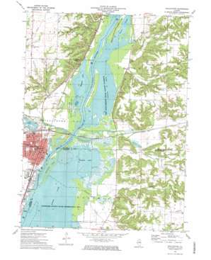
Chillicothe Topo Map Illinois
To zoom in, hover over the map of Chillicothe
USGS Topo Quad 40089h4 - 1:24,000 scale
| Topo Map Name: | Chillicothe |
| USGS Topo Quad ID: | 40089h4 |
| Print Size: | ca. 21 1/4" wide x 27" high |
| Southeast Coordinates: | 40.875° N latitude / 89.375° W longitude |
| Map Center Coordinates: | 40.9375° N latitude / 89.4375° W longitude |
| U.S. State: | IL |
| Filename: | o40089h4.jpg |
| Download Map JPG Image: | Chillicothe topo map 1:24,000 scale |
| Map Type: | Topographic |
| Topo Series: | 7.5´ |
| Map Scale: | 1:24,000 |
| Source of Map Images: | United States Geological Survey (USGS) |
| Alternate Map Versions: |
Chillicothe IL 1972, updated 1974 Download PDF Buy paper map Chillicothe IL 1972, updated 1974 Download PDF Buy paper map Chillicothe IL 2012 Download PDF Buy paper map Chillicothe IL 2015 Download PDF Buy paper map |
1:24,000 Topo Quads surrounding Chillicothe
> Back to 40089e1 at 1:100,000 scale
> Back to 40088a1 at 1:250,000 scale
> Back to U.S. Topo Maps home
Chillicothe topo map: Gazetteer
Chillicothe: Airports
Parrish RLA Airport elevation 196m 643′Chillicothe: Forests
Spring Branch State Conservation Area elevation 136m 446′Chillicothe: Islands
Chillicothe Island elevation 136m 446′Chillicothe: Lakes
Babb Slough elevation 136m 446′Devess Slough elevation 136m 446′
Douglas Lake elevation 136m 446′
Goose Lake elevation 136m 446′
Meadow Lake elevation 136m 446′
Sawyer Slough elevation 136m 446′
Chillicothe: Mines
Blue Blaze Number 1 Mine elevation 149m 488′Crew Mine elevation 161m 528′
Dobrich Mine elevation 152m 498′
Illinois Valley Number 2 Mine elevation 156m 511′
Owl Mine elevation 154m 505′
Sparland Mine elevation 157m 515′
Chillicothe: Parks
Aichison Waterfowl Refuge elevation 136m 446′Marshall County State Conservation Areas elevation 136m 446′
Santa Fe Park elevation 161m 528′
Woodford County State Conservation Area elevation 136m 446′
Chillicothe: Populated Places
Chillicothe elevation 153m 501′Coughlin elevation 144m 472′
Hopewell elevation 193m 633′
Chillicothe: Post Offices
Chillicothe Post Office elevation 146m 479′Chillicothe: Streams
Coon Creek elevation 146m 479′Coon Creek elevation 136m 446′
Cooper Run elevation 136m 446′
Crow Creek elevation 136m 446′
Dry Creek elevation 138m 452′
Pigeon Creek elevation 139m 456′
Richland Creek elevation 136m 446′
Senachwine Creek elevation 136m 446′
Snag Creek elevation 136m 446′
Strawn Creek elevation 139m 456′
Chillicothe: Valleys
Coal Hollow elevation 156m 511′Hardscrabble Hollow elevation 152m 498′
Rattlesnake Hollow elevation 139m 456′
Chillicothe digital topo map on disk
Buy this Chillicothe topo map showing relief, roads, GPS coordinates and other geographical features, as a high-resolution digital map file on DVD:
Northern Illinois, Northern Indiana & Southwestern Michigan
Buy digital topo maps: Northern Illinois, Northern Indiana & Southwestern Michigan


