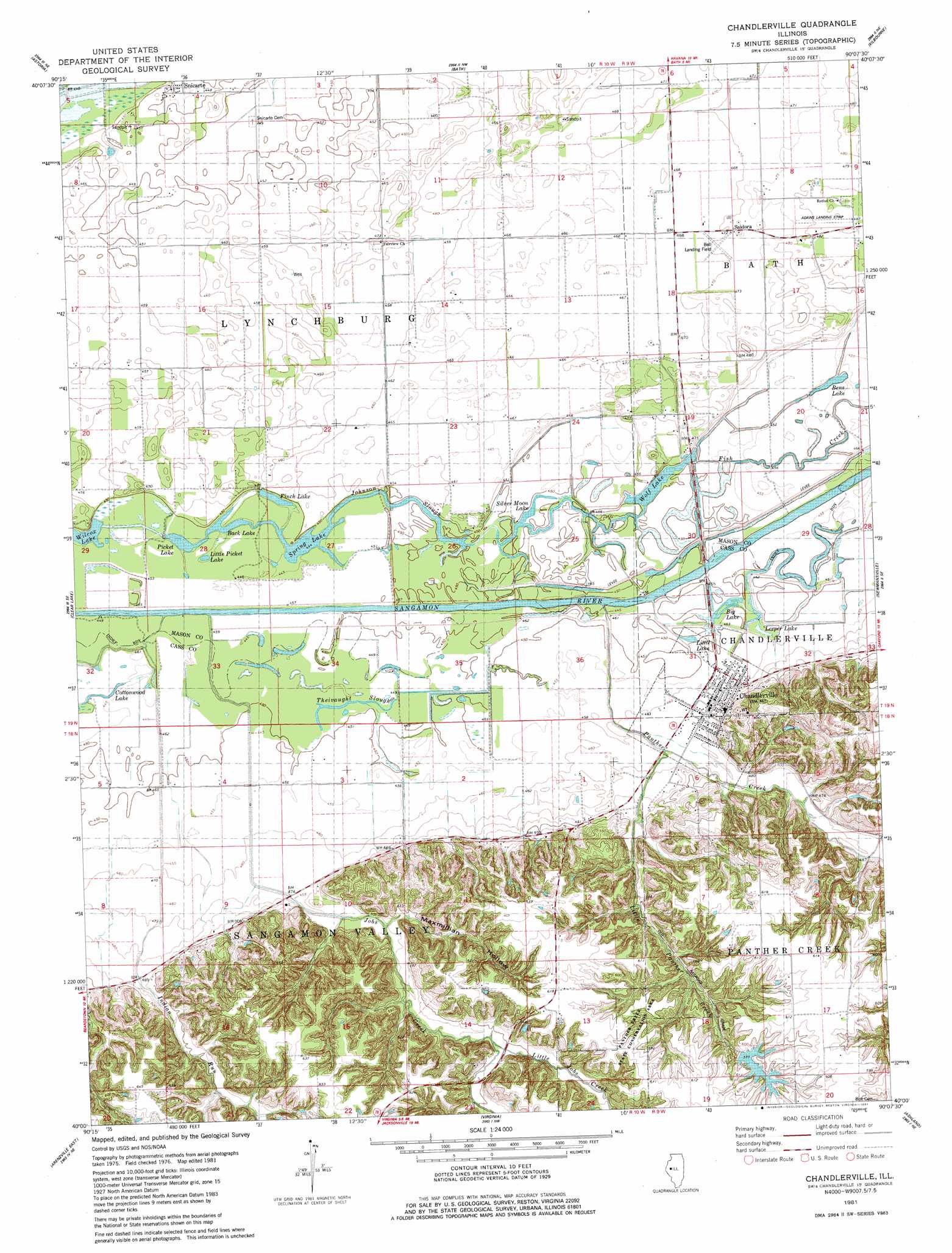
Chandlerville Topo Map Illinois
To zoom in, hover over the map of Chandlerville
USGS Topo Quad 40090a2 - 1:24,000 scale
| Topo Map Name: | Chandlerville |
| USGS Topo Quad ID: | 40090a2 |
| Print Size: | ca. 21 1/4" wide x 27" high |
| Southeast Coordinates: | 40° N latitude / 90.125° W longitude |
| Map Center Coordinates: | 40.0625° N latitude / 90.1875° W longitude |
| U.S. State: | IL |
| Filename: | o40090a2.jpg |
| Download Map JPG Image: | Chandlerville topo map 1:24,000 scale |
| Map Type: | Topographic |
| Topo Series: | 7.5´ |
| Map Scale: | 1:24,000 |
| Source of Map Images: | United States Geological Survey (USGS) |
| Alternate Map Versions: |
Chandlerville IL 1981, updated 1981 Download PDF Buy paper map Chandlerville IL 2012 Download PDF Buy paper map Chandlerville IL 2015 Download PDF Buy paper map |
1:24,000 Topo Quads surrounding Chandlerville
Vermont |
Ipava |
Duncan Mills |
Havana |
Topeka |
Ray |
Astoria |
Bath |
Kilbourne |
Biggs |
Beardstown |
Clear Lake |
Chandlerville |
Newmansville |
Oakford |
Arenzville West |
Arenzville East |
Virginia |
Ashland |
Tallula |
Chapin |
Concord |
Literberry |
Prentice |
Pleasant Plains |
> Back to 40090a1 at 1:100,000 scale
> Back to 40090a1 at 1:250,000 scale
> Back to U.S. Topo Maps home
Chandlerville topo map: Gazetteer
Chandlerville: Airports
Adkins Landing Strip elevation 148m 485′Bell Landing Field elevation 143m 469′
Chandlerville: Bays
Jeps Hole elevation 137m 449′Chandlerville: Canals
Fairview Ditch elevation 140m 459′Chandlerville: Dams
Finger Lake Dam elevation 175m 574′Chandlerville: Guts
Fish Creek elevation 137m 449′Johnson Slough elevation 135m 442′
Theivaught Slough elevation 137m 449′
Chandlerville: Islands
Briar Island elevation 136m 446′Chandlerville: Lakes
Back Lake elevation 136m 446′Bens Lake elevation 137m 449′
Big Lake elevation 138m 452′
Calomel Lake elevation 137m 449′
Cottonwood Lake elevation 135m 442′
Cottonwood Lake (historical) elevation 137m 449′
Cow Lake elevation 135m 442′
Finch Lake elevation 137m 449′
Leeper Lake elevation 138m 452′
Little Lake elevation 137m 449′
Little Picket Lake elevation 135m 442′
Mound Lake elevation 135m 442′
Picket Lake elevation 135m 442′
Pike Lake elevation 137m 449′
Prairie Lake elevation 137m 449′
Silver Moon Lake elevation 135m 442′
Spring Lake elevation 135m 442′
Wily Wake elevation 137m 449′
Wolf Lake elevation 136m 446′
Chandlerville: Parks
Panther Creek State Conservation Area elevation 169m 554′Chandlerville: Populated Places
Chandlerville elevation 141m 462′Palmerton elevation 186m 610′
Saidora elevation 146m 479′
Snicarte elevation 135m 442′
Wolf Lake elevation 143m 469′
Chandlerville: Reservoirs
Finger Lake elevation 175m 574′Chandlerville: Streams
Indian Run elevation 135m 442′Jobs Creek elevation 135m 442′
Little Jobs Creek elevation 148m 485′
Little Panther Creek elevation 140m 459′
Panther Creek elevation 137m 449′
Chandlerville: Valleys
Maxmillian Hollow elevation 149m 488′Chandlerville digital topo map on disk
Buy this Chandlerville topo map showing relief, roads, GPS coordinates and other geographical features, as a high-resolution digital map file on DVD: