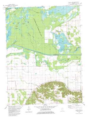
Clear Lake Topo Map Illinois
To zoom in, hover over the map of Clear Lake
USGS Topo Quad 40090a3 - 1:24,000 scale
| Topo Map Name: | Clear Lake |
| USGS Topo Quad ID: | 40090a3 |
| Print Size: | ca. 21 1/4" wide x 27" high |
| Southeast Coordinates: | 40° N latitude / 90.25° W longitude |
| Map Center Coordinates: | 40.0625° N latitude / 90.3125° W longitude |
| U.S. State: | IL |
| Filename: | o40090a3.jpg |
| Download Map JPG Image: | Clear Lake topo map 1:24,000 scale |
| Map Type: | Topographic |
| Topo Series: | 7.5´ |
| Map Scale: | 1:24,000 |
| Source of Map Images: | United States Geological Survey (USGS) |
| Alternate Map Versions: |
Clear Lake IL 1981, updated 1981 Download PDF Buy paper map Clear Lake IL 2012 Download PDF Buy paper map Clear Lake IL 2015 Download PDF Buy paper map |
1:24,000 Topo Quads surrounding Clear Lake
> Back to 40090a1 at 1:100,000 scale
> Back to 40090a1 at 1:250,000 scale
> Back to U.S. Topo Maps home
Clear Lake topo map: Gazetteer
Clear Lake: Areas
Eagle Prairie elevation 134m 439′Clear Lake: Bays
Sangamon Bay elevation 134m 439′Clear Lake: Flats
McKay Flats elevation 134m 439′Clear Lake: Guts
Ash Swale elevation 134m 439′Bach Slough elevation 134m 439′
Duck Slough elevation 134m 439′
Eagle Slough elevation 134m 439′
Hog Slough elevation 134m 439′
Swamp Slough elevation 132m 433′
Clear Lake: Islands
Cuba Island elevation 136m 446′Sand Island elevation 135m 442′
Clear Lake: Lakes
Carp Hole elevation 134m 439′Clear Lake elevation 134m 439′
Collis Pond elevation 134m 439′
Crane Lake elevation 134m 439′
Crow Hole elevation 132m 433′
Eagle Lake elevation 132m 433′
Lower Crow Hole elevation 132m 433′
McCarty Slough elevation 134m 439′
Mound Lake elevation 134m 439′
Otter Lake elevation 134m 439′
Pinoak Lake elevation 134m 439′
Point Lake elevation 136m 446′
Redhead Lake elevation 132m 433′
River Swale elevation 134m 439′
Toppers Hole elevation 134m 439′
Weiner Swale elevation 134m 439′
Wilcox Lake elevation 136m 446′
Wood Duck Slough elevation 132m 433′
Clear Lake: Parks
Sanganois State Conservation Area elevation 132m 433′Toppers Hole State Conservation Area elevation 132m 433′
Clear Lake: Populated Places
Clear Lake elevation 135m 442′Clear Lake: Streams
Coon Slough elevation 132m 433′Little Sangamon River elevation 134m 439′
Lost Creek elevation 136m 446′
Clear Lake digital topo map on disk
Buy this Clear Lake topo map showing relief, roads, GPS coordinates and other geographical features, as a high-resolution digital map file on DVD:


