Farmington West Topo Map Illinois
To zoom in, hover over the map of Farmington West
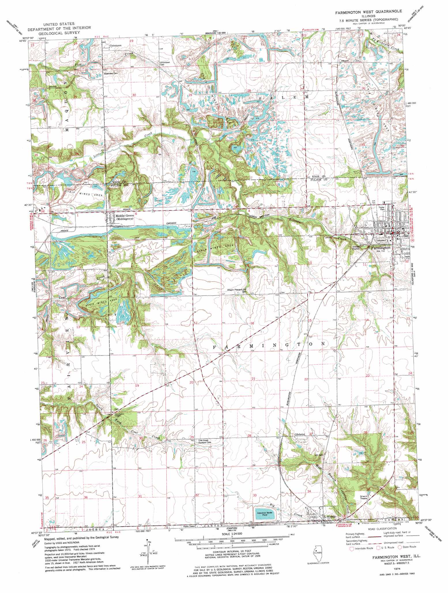
USGS Topo Quad 40090f1 - 1:24,000 scale
| Topo Map Name: | Farmington West |
| USGS Topo Quad ID: | 40090f1 |
| Print Size: | ca. 21 1/4" wide x 27" high |
| Southeast Coordinates: | 40.625° N latitude / 90° W longitude |
| Map Center Coordinates: | 40.6875° N latitude / 90.0625° W longitude |
| U.S. State: | IL |
| Filename: | o40090f1.jpg |
| Download Map JPG Image: | Farmington West topo map 1:24,000 scale |
| Map Type: | Topographic |
| Topo Series: | 7.5´ |
| Map Scale: | 1:24,000 |
| Source of Map Images: | United States Geological Survey (USGS) |
| Alternate Map Versions: |
Farmington West IL 1974, updated 1978 Download PDF Buy paper map Farmington West IL 2012 Download PDF Buy paper map Farmington West IL 2015 Download PDF Buy paper map |
1:24,000 Topo Quads surrounding Farmington West
Galesburg East |
Appleton |
Williamsfield |
Laura |
Princeville |
De Long |
Maquon |
Yates City |
Elmwood |
Oak Hill |
London Mills |
Fairview |
Farmington West |
Farmington East |
Hanna City |
Blyton |
Fiatt |
Canton |
Banner |
Glasford |
Smithfield |
Lewiston |
Saint David |
Duck Island |
Manito |
> Back to 40090e1 at 1:100,000 scale
> Back to 40090a1 at 1:250,000 scale
> Back to U.S. Topo Maps home
Farmington West topo map: Gazetteer
Farmington West: Dams
Midland Employee Lake Dam elevation 206m 675′Farmington West: Mines
Alden Mine Number 5 elevation 228m 748′Alden Mine Number 6 elevation 229m 751′
Maplewood Mine Number 1 elevation 212m 695′
Maplewood Mine Number 2 elevation 229m 751′
National Mine elevation 218m 715′
Farmington West: Populated Places
Farmington elevation 227m 744′Forty Acres elevation 229m 751′
Gilchrist elevation 232m 761′
Middlegrove elevation 219m 718′
Norris elevation 222m 728′
Uniontown elevation 208m 682′
Farmington West: Post Offices
Farmington Post Office elevation 226m 741′Farmington Post Office elevation 227m 744′
Middlegrove Post Office elevation 220m 721′
Norris Post Office elevation 223m 731′
Farmington West: Reservoirs
Midland Employee Lake elevation 206m 675′Farmington West digital topo map on disk
Buy this Farmington West topo map showing relief, roads, GPS coordinates and other geographical features, as a high-resolution digital map file on DVD: