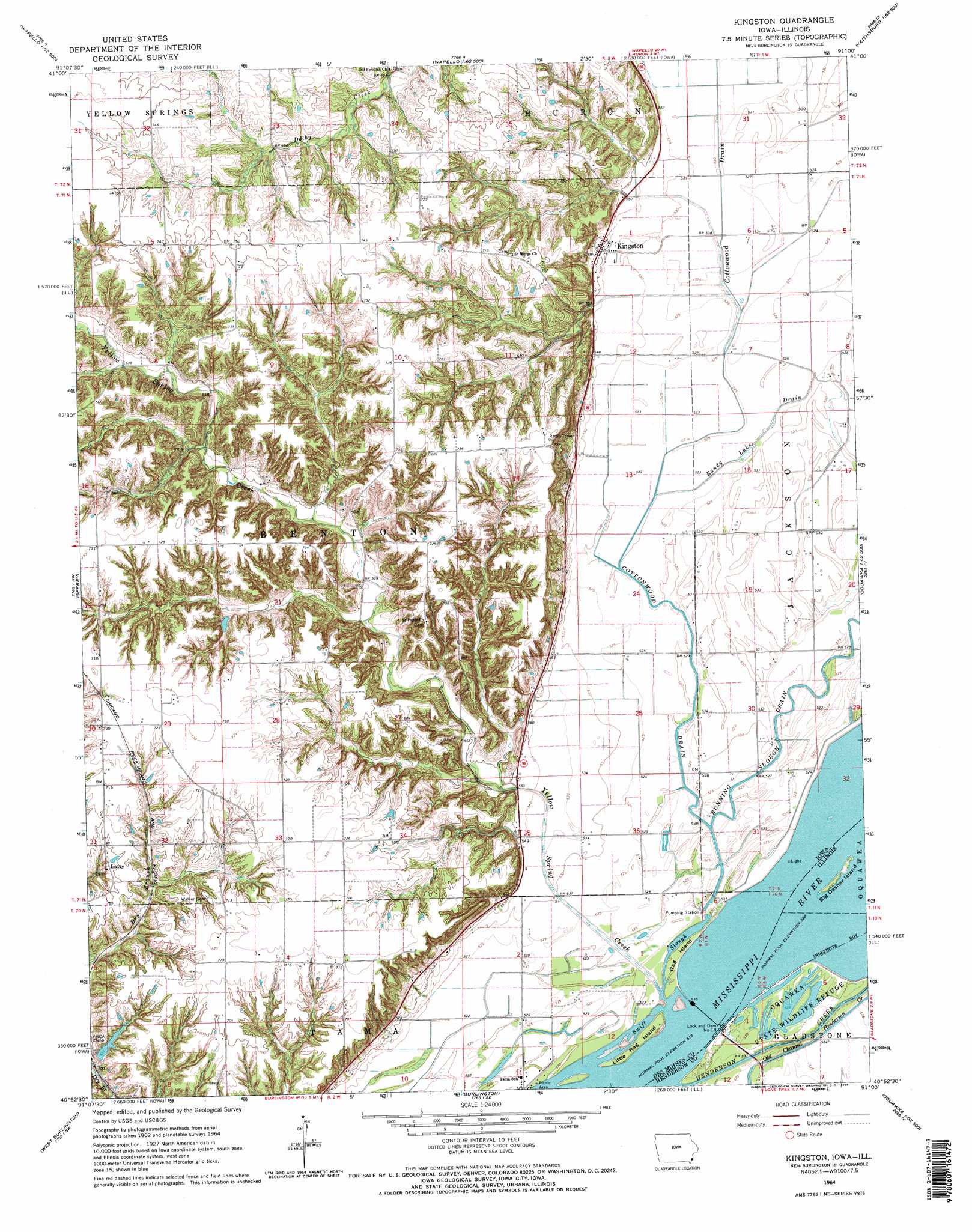
Kingston Topo Map Iowa
To zoom in, hover over the map of Kingston
USGS Topo Quad 40091h1 - 1:24,000 scale
| Topo Map Name: | Kingston |
| USGS Topo Quad ID: | 40091h1 |
| Print Size: | ca. 21 1/4" wide x 27" high |
| Southeast Coordinates: | 40.875° N latitude / 91° W longitude |
| Map Center Coordinates: | 40.9375° N latitude / 91.0625° W longitude |
| U.S. States: | IA, IL |
| Filename: | o40091h1.jpg |
| Download Map JPG Image: | Kingston topo map 1:24,000 scale |
| Map Type: | Topographic |
| Topo Series: | 7.5´ |
| Map Scale: | 1:24,000 |
| Source of Map Images: | United States Geological Survey (USGS) |
| Alternate Map Versions: |
Kingston IA 1964, updated 1966 Download PDF Buy paper map Kingston IA 1964, updated 1966 Download PDF Buy paper map Kingston IA 2010 Download PDF Buy paper map Kingston IA 2013 Download PDF Buy paper map Kingston IA 2015 Download PDF Buy paper map |
1:24,000 Topo Quads surrounding Kingston
Cairo |
Wapello |
Toolesboro |
Joy |
Aledo West |
Morning Sun |
Mediapolis |
Oakville |
Keithsburg |
Seaton |
Pleasant Grove |
Sperry |
Kingston |
Oquawka |
Rozetta |
Danville |
West Burlington |
Burlington |
Gladstone |
Kirkwood West |
Fort Madison |
Dallas City |
Lomax |
Stronghurst |
Raritan |
> Back to 40091e1 at 1:100,000 scale
> Back to 40090a1 at 1:250,000 scale
> Back to U.S. Topo Maps home
Kingston topo map: Gazetteer
Kingston: Bridges
Yellow Spring Creek Bridge elevation 211m 692′Kingston: Channels
Swift Slough elevation 161m 528′Kingston: Dams
Lock and Dam Number 18 elevation 161m 528′Lock and Dam Number 18 elevation 161m 528′
Mississippi River Lock Dam Number Eighteen elevation 159m 521′
Kingston: Guts
Old Channel Henderson Creek elevation 162m 531′Kingston: Islands
Big Dasher Island elevation 161m 528′Little Rag Island elevation 160m 524′
Rag Island elevation 161m 528′
Kingston: Lakes
Bradley Lake (historical) elevation 163m 534′Kingston: Parks
Malchow Mounds Preserve elevation 169m 554′Oquawka State Wildlife Refuge elevation 161m 528′
Kingston: Populated Places
Kingston elevation 168m 551′Latty elevation 211m 692′
Kingston: Post Offices
Albrights Post Office (historical) elevation 167m 547′Amity Post Office (historical) elevation 213m 698′
Cora Post Office (historical) elevation 214m 702′
Kingston Post Office (historical) elevation 168m 551′
Latty Post Office (historical) elevation 211m 692′
Kingston: Streams
Cottonwood Drain elevation 159m 521′Henderson Creek elevation 160m 524′
Running Slough Drain elevation 157m 515′
Yellow Spring Creek elevation 160m 524′
Kingston digital topo map on disk
Buy this Kingston topo map showing relief, roads, GPS coordinates and other geographical features, as a high-resolution digital map file on DVD: