Centerville West Topo Map Iowa
To zoom in, hover over the map of Centerville West
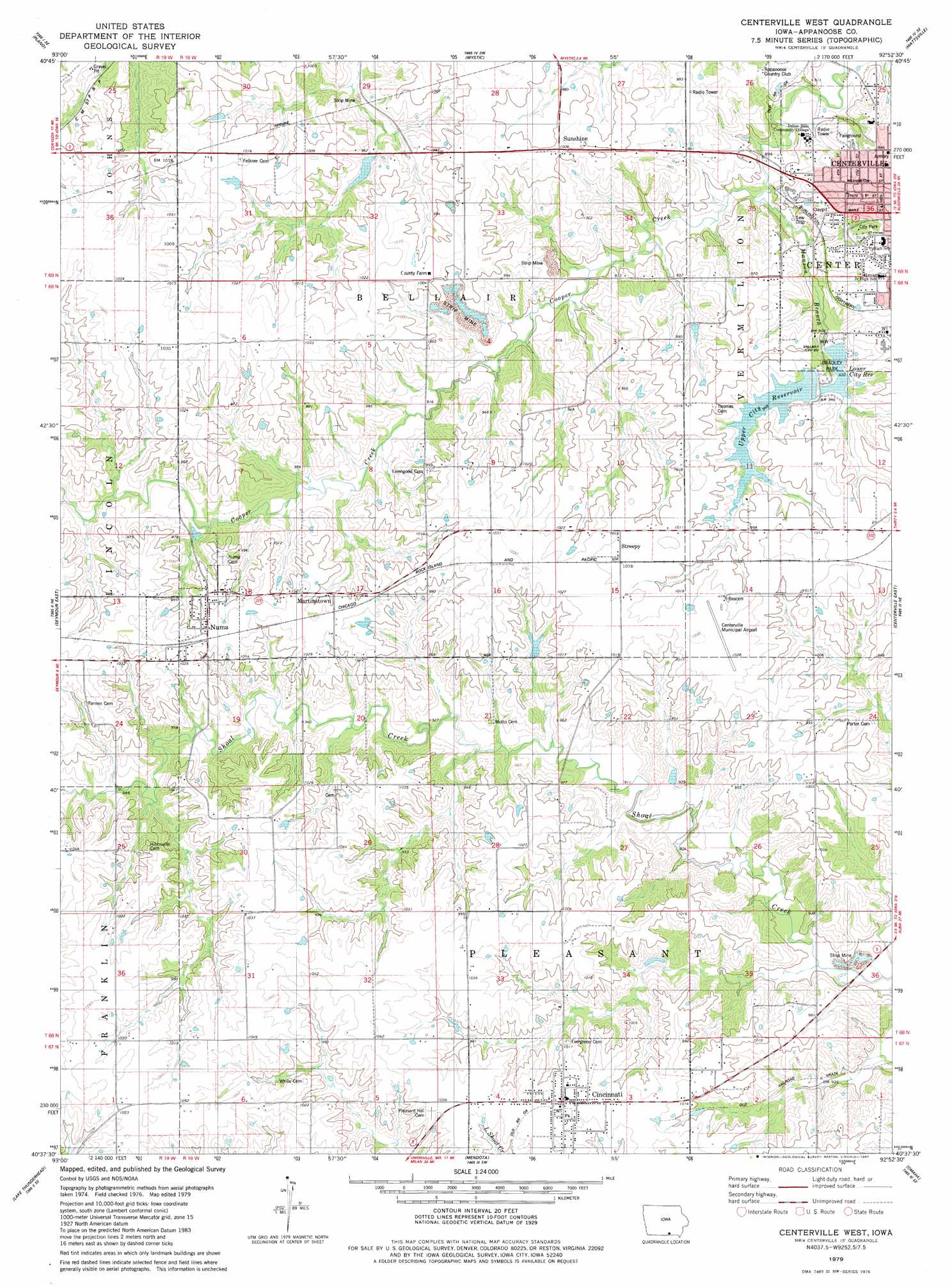
USGS Topo Quad 40092f8 - 1:24,000 scale
| Topo Map Name: | Centerville West |
| USGS Topo Quad ID: | 40092f8 |
| Print Size: | ca. 21 1/4" wide x 27" high |
| Southeast Coordinates: | 40.625° N latitude / 92.875° W longitude |
| Map Center Coordinates: | 40.6875° N latitude / 92.9375° W longitude |
| U.S. State: | IA |
| Filename: | o40092f8.jpg |
| Download Map JPG Image: | Centerville West topo map 1:24,000 scale |
| Map Type: | Topographic |
| Topo Series: | 7.5´ |
| Map Scale: | 1:24,000 |
| Source of Map Images: | United States Geological Survey (USGS) |
| Alternate Map Versions: |
Centerville West IA 1979, updated 1980 Download PDF Buy paper map Centerville West IA 2010 Download PDF Buy paper map Centerville West IA 2013 Download PDF Buy paper map Centerville West IA 2015 Download PDF Buy paper map |
1:24,000 Topo Quads surrounding Centerville West
Russell |
Melrose |
Iconium |
Moravia |
Blakesburg |
Confidence |
Plano |
Mystic |
Hiattsville |
Unionville |
Seymour West |
Seymour East |
Centerville West |
Centerville East |
Moulton |
Saint John |
Lake Thunderhead |
Mendota |
Omaha |
Coatsville |
Pollock Nw |
Unionville West |
Unionville East |
Graysville |
Livonia |
> Back to 40092e1 at 1:100,000 scale
> Back to 40092a1 at 1:250,000 scale
> Back to U.S. Topo Maps home
Centerville West topo map: Gazetteer
Centerville West: Airports
Centerville Municipal Airport elevation 313m 1026′Centerville West: Parks
Bradley Park elevation 293m 961′Centerville West: Populated Places
Bellair (historical) elevation 307m 1007′Cincinnati elevation 313m 1026′
Martinstown elevation 311m 1020′
Numa elevation 313m 1026′
Streepy elevation 310m 1017′
Sunshine elevation 306m 1003′
Centerville West: Post Offices
Bellair Post Office (historical) elevation 307m 1007′Centerville Post Office elevation 306m 1003′
Cincinnati Post Office elevation 313m 1026′
Hibbsville Post Office (historical) elevation 306m 1003′
Numa Post Office elevation 313m 1026′
Centerville West: Reservoirs
Lower City Reservoir elevation 283m 928′Upper City Reservoir elevation 293m 961′
Centerville West: Streams
Manson Branch elevation 266m 872′Centerville West digital topo map on disk
Buy this Centerville West topo map showing relief, roads, GPS coordinates and other geographical features, as a high-resolution digital map file on DVD: