Albany North Topo Map Missouri
To zoom in, hover over the map of Albany North
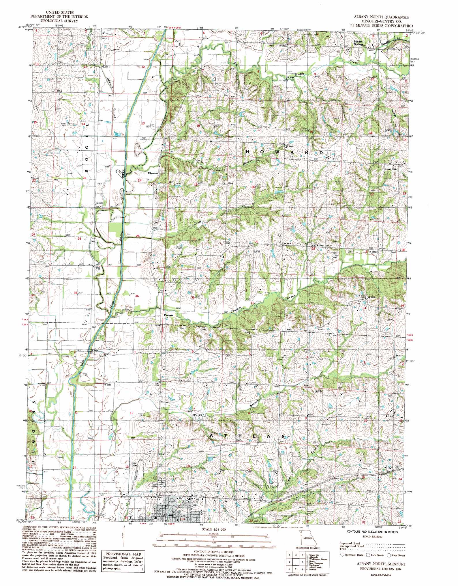
USGS Topo Quad 40094c3 - 1:24,000 scale
| Topo Map Name: | Albany North |
| USGS Topo Quad ID: | 40094c3 |
| Print Size: | ca. 21 1/4" wide x 27" high |
| Southeast Coordinates: | 40.25° N latitude / 94.25° W longitude |
| Map Center Coordinates: | 40.3125° N latitude / 94.3125° W longitude |
| U.S. State: | MO |
| Filename: | o40094c3.jpg |
| Download Map JPG Image: | Albany North topo map 1:24,000 scale |
| Map Type: | Topographic |
| Topo Series: | 7.5´ |
| Map Scale: | 1:24,000 |
| Source of Map Images: | United States Geological Survey (USGS) |
| Alternate Map Versions: |
Albany North MO 1984, updated 1985 Download PDF Buy paper map Albany North MO 2011 Download PDF Buy paper map Albany North MO 2014 Download PDF Buy paper map |
1:24,000 Topo Quads surrounding Albany North
Sheridan |
Blockton |
Blockton Se |
Hatfield |
Pawnee |
Parnell East |
Grant City |
Allendale |
Washington Center |
Brooklyn |
Alanthus Grove |
Gentry |
Albany North |
New Hampton |
Bethany |
Stanberry |
Darlington |
Albany South |
Matkin |
Mitchellville |
King City |
Ford City |
Berlin |
Pattonsburg |
Coffey |
> Back to 40094a1 at 1:100,000 scale
> Back to 40094a1 at 1:250,000 scale
> Back to U.S. Topo Maps home
Albany North topo map: Gazetteer
Albany North: Airports
Albany Municipal Airport elevation 265m 869′Albany North: Populated Places
Ellenorah elevation 282m 925′Lone Star elevation 321m 1053′
Pinhook elevation 267m 875′
Siloam Springs elevation 292m 958′
Albany North: Streams
Big Muddy Creek elevation 259m 849′Chalk Run elevation 260m 853′
Clayber Branch elevation 264m 866′
Dawson Branch elevation 263m 862′
Little Muddy Creek elevation 275m 902′
Panther Creek elevation 257m 843′
Weldon Branch elevation 256m 839′
Albany North: Valleys
Possum Hollow elevation 278m 912′Albany North digital topo map on disk
Buy this Albany North topo map showing relief, roads, GPS coordinates and other geographical features, as a high-resolution digital map file on DVD: