Lewiston Topo Map Nebraska
To zoom in, hover over the map of Lewiston
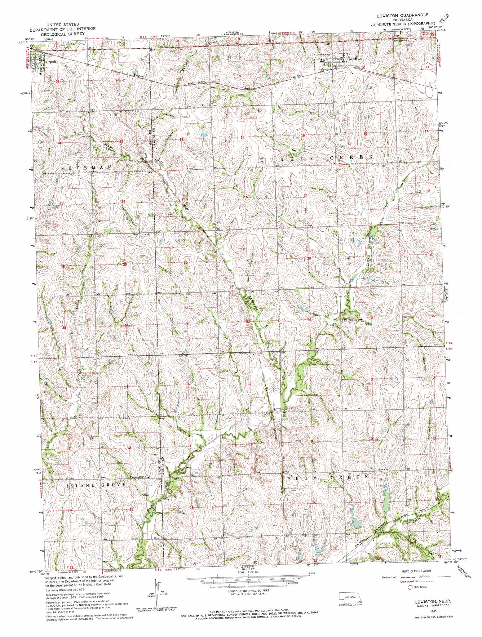
USGS Topo Quad 40096b4 - 1:24,000 scale
| Topo Map Name: | Lewiston |
| USGS Topo Quad ID: | 40096b4 |
| Print Size: | ca. 21 1/4" wide x 27" high |
| Southeast Coordinates: | 40.125° N latitude / 96.375° W longitude |
| Map Center Coordinates: | 40.1875° N latitude / 96.4375° W longitude |
| U.S. State: | NE |
| Filename: | O40096b4.jpg |
| Download Map JPG Image: | Lewiston topo map 1:24,000 scale |
| Map Type: | Topographic |
| Topo Series: | 7.5´ |
| Map Scale: | 1:24,000 |
| Source of Map Images: | United States Geological Survey (USGS) |
| Alternate Map Versions: |
Lewiston NE 1965, updated 1966 Download PDF Buy paper map Lewiston NE 2011 Download PDF Buy paper map Lewiston NE 2014 Download PDF Buy paper map |
1:24,000 Topo Quads surrounding Lewiston
Pickrell |
Adams |
Sterling |
Saint Mary |
Tecumseh Nw |
Beatrice East |
Filley |
Crab Orchard |
Vesta |
Tecumseh |
Blue Springs |
Wymore Ne |
Lewiston |
Burchard |
Steinauer |
Wymore |
Barneston |
Liberty |
Liberty Se |
Pawnee City |
Herkimer |
Oketo |
Axtell Nw |
Summerfield |
Seneca Nw |
> Back to 40096a1 at 1:100,000 scale
> Back to 40096a1 at 1:250,000 scale
> Back to U.S. Topo Maps home
Lewiston topo map: Gazetteer
Lewiston: Dams
Plum Creek Dam 4-B elevation 407m 1335′Plum Creek Dam 4-D elevation 409m 1341′
Plum Creek Dam 4-E elevation 406m 1332′
Plum Creek Dam 4-F elevation 407m 1335′
Plum Creek Dam 4-G elevation 407m 1335′
Lewiston: Populated Places
Lewiston elevation 446m 1463′Tate (historical) elevation 424m 1391′
Virginia elevation 466m 1528′
Lewiston: Post Offices
Lewiston Post Office elevation 446m 1463′Tate Post Office (historical) elevation 424m 1391′
Virginia Post Office elevation 466m 1528′
Lewiston: Reservoirs
Plum Creek Reservoir 4-B elevation 407m 1335′Plum Creek Reservoir 4-D elevation 409m 1341′
Plum Creek Reservoir 4-E elevation 406m 1332′
Plum Creek Reservoir 4-F elevation 407m 1335′
Plum Creek Reservoir 4-G elevation 407m 1335′
Lewiston: Streams
Adamson Creek elevation 403m 1322′Plum Creek elevation 408m 1338′
Tipps Creek elevation 402m 1318′
Lewiston digital topo map on disk
Buy this Lewiston topo map showing relief, roads, GPS coordinates and other geographical features, as a high-resolution digital map file on DVD: