Harbine Topo Map Nebraska
To zoom in, hover over the map of Harbine
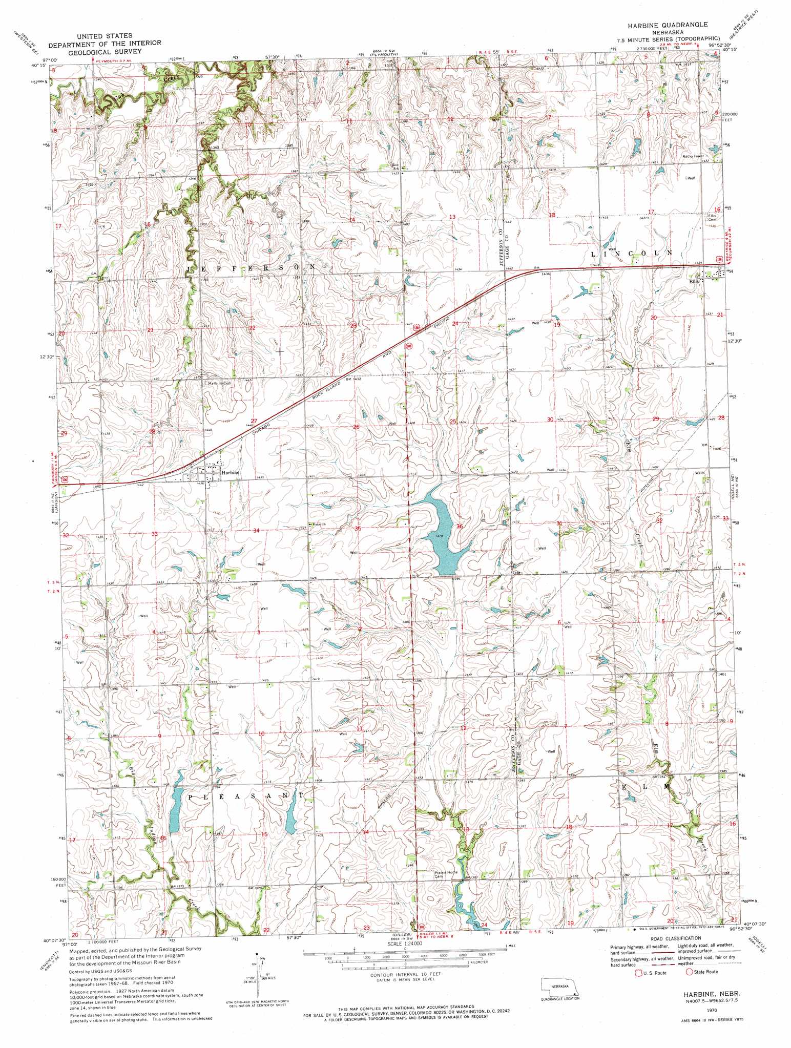
USGS Topo Quad 40096b8 - 1:24,000 scale
| Topo Map Name: | Harbine |
| USGS Topo Quad ID: | 40096b8 |
| Print Size: | ca. 21 1/4" wide x 27" high |
| Southeast Coordinates: | 40.125° N latitude / 96.875° W longitude |
| Map Center Coordinates: | 40.1875° N latitude / 96.9375° W longitude |
| U.S. State: | NE |
| Filename: | O40096b8.jpg |
| Download Map JPG Image: | Harbine topo map 1:24,000 scale |
| Map Type: | Topographic |
| Topo Series: | 7.5´ |
| Map Scale: | 1:24,000 |
| Source of Map Images: | United States Geological Survey (USGS) |
| Alternate Map Versions: |
Harbine NE 1970, updated 1972 Download PDF Buy paper map Harbine NE 2011 Download PDF Buy paper map Harbine NE 2014 Download PDF Buy paper map |
1:24,000 Topo Quads surrounding Harbine
Western |
Swanton |
Wilber |
Clatonia |
Pickrell |
Western Sw |
Western Se |
Plymouth |
Beatrice West |
Beatrice East |
Fairbury |
Jansen |
Harbine |
Odell Ne |
Blue Springs |
Fairbury Sw |
Endicott |
Diller |
Odell |
Wymore |
Washington Nw |
Washington Ne |
Hanover West |
Hanover East |
Herkimer |
> Back to 40096a1 at 1:100,000 scale
> Back to 40096a1 at 1:250,000 scale
> Back to U.S. Topo Maps home
Harbine topo map: Gazetteer
Harbine: Dams
Big Indian Creek Dam 16-B elevation 417m 1368′Cub Creek Dam 8-C elevation 412m 1351′
Cub Creek Dam G-7 elevation 410m 1345′
Detention Dam 17-B elevation 419m 1374′
Detention Dam 8-B elevation 412m 1351′
Detention Dam 8-B-1 elevation 422m 1384′
Detention Dam 9-B elevation 419m 1374′
Harbine: Populated Places
Ellis elevation 436m 1430′Harbine elevation 439m 1440′
Harbine: Post Offices
Ellis Post Office (historical) elevation 436m 1430′Harbine Post Office (historical) elevation 439m 1440′
Harbine: Reservoirs
Big Indian Creek Reservoir 16-B elevation 417m 1368′Big Indian Creek Reservoir 17-B elevation 419m 1374′
Big Indian Creek Reservoir 8-B elevation 422m 1384′
Big Indian Creek Reservoir 9-B elevation 419m 1374′
Cub Creek Reservoir 8-B elevation 412m 1351′
Cub Creek Reservoir 8-C elevation 412m 1351′
Cub Creek Reservoir G-7 elevation 410m 1345′
Harbine digital topo map on disk
Buy this Harbine topo map showing relief, roads, GPS coordinates and other geographical features, as a high-resolution digital map file on DVD: