Sterling Topo Map Nebraska
To zoom in, hover over the map of Sterling
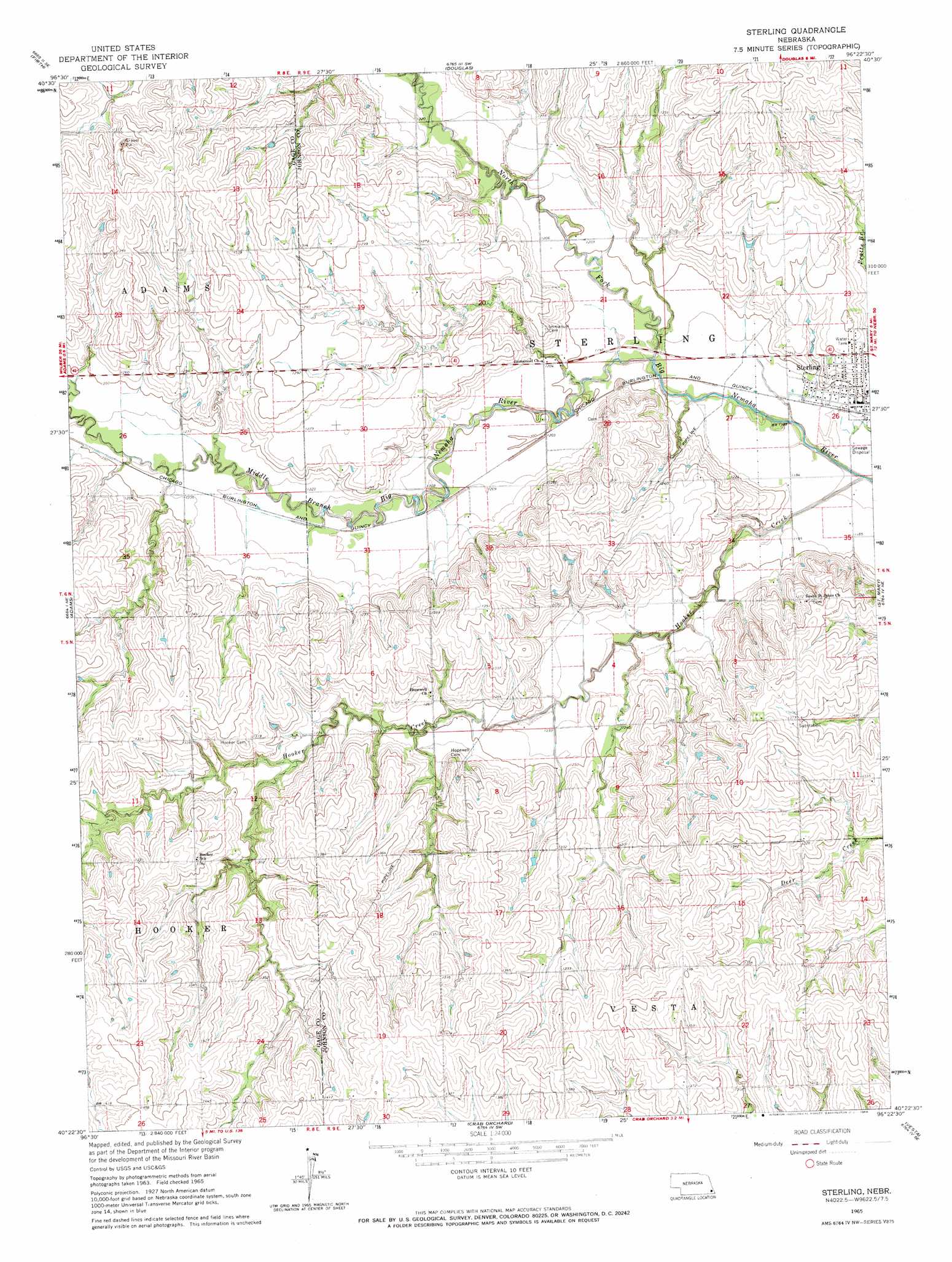
USGS Topo Quad 40096d4 - 1:24,000 scale
| Topo Map Name: | Sterling |
| USGS Topo Quad ID: | 40096d4 |
| Print Size: | ca. 21 1/4" wide x 27" high |
| Southeast Coordinates: | 40.375° N latitude / 96.375° W longitude |
| Map Center Coordinates: | 40.4375° N latitude / 96.4375° W longitude |
| U.S. State: | NE |
| Filename: | O40096d4.jpg |
| Download Map JPG Image: | Sterling topo map 1:24,000 scale |
| Map Type: | Topographic |
| Topo Series: | 7.5´ |
| Map Scale: | 1:24,000 |
| Source of Map Images: | United States Geological Survey (USGS) |
| Alternate Map Versions: |
Sterling NE 1965, updated 1966 Download PDF Buy paper map Sterling NE 2011 Download PDF Buy paper map Sterling NE 2014 Download PDF Buy paper map |
1:24,000 Topo Quads surrounding Sterling
Roca |
Bennet |
Palmyra |
Unadilla |
Syracuse |
Cortland |
Firth |
Douglas |
Burr |
Cook |
Pickrell |
Adams |
Sterling |
Saint Mary |
Tecumseh Nw |
Beatrice East |
Filley |
Crab Orchard |
Vesta |
Tecumseh |
Blue Springs |
Wymore Ne |
Lewiston |
Burchard |
Steinauer |
> Back to 40096a1 at 1:100,000 scale
> Back to 40096a1 at 1:250,000 scale
> Back to U.S. Topo Maps home
Sterling topo map: Gazetteer
Sterling: Dams
Upper Big Nemaha Dam 18-A elevation 391m 1282′Upper Big Nemaha Dam 2-A elevation 372m 1220′
Upper Big Nemaha Dam 6-A elevation 380m 1246′
Upper Big Nemaha Dam G-12 elevation 397m 1302′
Upper Big Nemaha Dam G-19 elevation 409m 1341′
Upper Big Nemaha Dam G-2 elevation 407m 1335′
Upper Big Nemaha Dam G-20 elevation 406m 1332′
Upper Big Nemaha Dam G-31 elevation 395m 1295′
Upper Big Nemaha Dam J-15A elevation 378m 1240′
Upper Big Nemaha Dam J-28 elevation 391m 1282′
Upper Big Nemaha Dam J-34 elevation 411m 1348′
Upper Big Nemaha Dam J-37 elevation 400m 1312′
Sterling: Parks
Sterling Village Park elevation 362m 1187′Sterling: Populated Places
Sterling elevation 362m 1187′Sterling: Post Offices
Hooker Post Office (historical) elevation 408m 1338′Sterling Post Office elevation 362m 1187′
Sterling: Reservoirs
Upper Big Nemaha Reservoir 18-A elevation 391m 1282′Upper Big Nemaha Reservoir 2-A elevation 372m 1220′
Upper Big Nemaha Reservoir 6-A elevation 380m 1246′
Upper Big Nemaha Reservoir G-12 elevation 397m 1302′
Upper Big Nemaha Reservoir G-19 elevation 409m 1341′
Upper Big Nemaha Reservoir G-2 elevation 407m 1335′
Upper Big Nemaha Reservoir G-20 elevation 406m 1332′
Upper Big Nemaha Reservoir G-31 elevation 395m 1295′
Upper Big Nemaha Reservoir J-15A elevation 378m 1240′
Upper Big Nemaha Reservoir J-28 elevation 391m 1282′
Upper Big Nemaha Reservoir J-34 elevation 411m 1348′
Upper Big Nemaha Reservoir J-37 elevation 400m 1312′
Sterling: Streams
Hooker Creek elevation 351m 1151′Middle Branch Big Nemaha River elevation 355m 1164′
Sterling digital topo map on disk
Buy this Sterling topo map showing relief, roads, GPS coordinates and other geographical features, as a high-resolution digital map file on DVD: