Talmage Topo Map Nebraska
To zoom in, hover over the map of Talmage
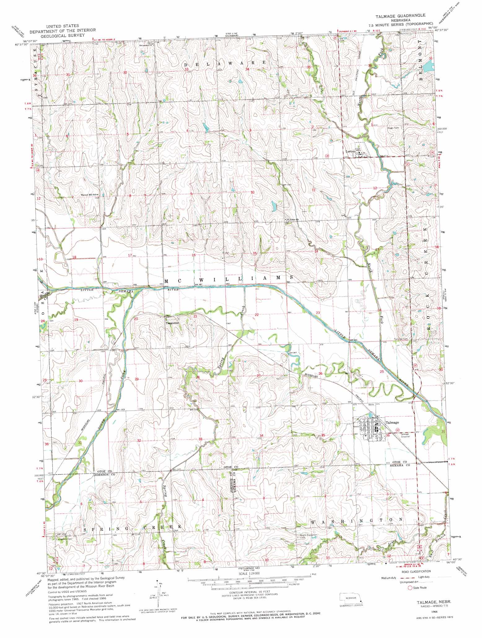
USGS Topo Quad 40096e1 - 1:24,000 scale
| Topo Map Name: | Talmage |
| USGS Topo Quad ID: | 40096e1 |
| Print Size: | ca. 21 1/4" wide x 27" high |
| Southeast Coordinates: | 40.5° N latitude / 96° W longitude |
| Map Center Coordinates: | 40.5625° N latitude / 96.0625° W longitude |
| U.S. State: | NE |
| Filename: | O40096e1.jpg |
| Download Map JPG Image: | Talmage topo map 1:24,000 scale |
| Map Type: | Topographic |
| Topo Series: | 7.5´ |
| Map Scale: | 1:24,000 |
| Source of Map Images: | United States Geological Survey (USGS) |
| Alternate Map Versions: |
Talmage NE 1966, updated 1968 Download PDF Buy paper map Talmage NE 2012 Download PDF Buy paper map Talmage NE 2014 Download PDF Buy paper map |
1:24,000 Topo Quads surrounding Talmage
Elmwood |
Weeping Water |
Avoca |
Nehawka |
Mcpaul |
Unadilla |
Syracuse |
Dunbar |
Nebraska City Nw |
Nebraska City |
Burr |
Cook |
Talmage |
Paul |
Julian |
Saint Mary |
Tecumseh Nw |
Tecumseh Ne |
Brock |
Auburn |
Vesta |
Tecumseh |
Tecumseh Se |
Howe Sw |
Howe |
> Back to 40096e1 at 1:100,000 scale
> Back to 40096a1 at 1:250,000 scale
> Back to U.S. Topo Maps home
Talmage topo map: Gazetteer
Talmage: Dams
Little Nemaha River Dam 3-1 elevation 311m 1020′Little Nemaha River Dam 3-1A elevation 303m 994′
Little Nemaha River Dam 3-1B elevation 317m 1040′
N F Little Nemaha Dam 4-14 elevation 311m 1020′
Spring Creek Dam 2-3 elevation 317m 1040′
Spring Creek Dam 3-1 elevation 319m 1046′
Spring Creek Dam 4-3 elevation 319m 1046′
Wilson Creek Dam 1-F elevation 325m 1066′
Wilson Creek Dam 3-2 elevation 321m 1053′
Wilson Creek Dam 3-6 elevation 338m 1108′
Wilson Creek Dam 3-C elevation 325m 1066′
Talmage: Parks
Talmage Nebraska Historical Marker elevation 299m 980′Talmage: Populated Places
Cio (historical) elevation 314m 1030′Delta (historical) elevation 314m 1030′
Lorton elevation 314m 1030′
Talmage elevation 299m 980′
Tangeman elevation 307m 1007′
Talmage: Post Offices
Delaware City Post Office (historical) elevation 368m 1207′Delta Post Office (historical) elevation 314m 1030′
Grant Post Office (historical) elevation 321m 1053′
Lorton Post Office elevation 314m 1030′
Talmage Post Office elevation 299m 980′
Talmage: Reservoirs
Little Nemaha River Reservoir 3-1 elevation 311m 1020′Little Nemaha River Reservoir 3-1A elevation 303m 994′
Little Nemaha River Reservoir 3-1B elevation 317m 1040′
N F Little Nemaha Reservoir 4-14 elevation 311m 1020′
Spring Creek Reservoir 2-3 elevation 317m 1040′
Spring Creek Reservoir 3-1 elevation 319m 1046′
Spring Creek Reservoir 4-3 elevation 319m 1046′
Wilson Creek Reservoir elevation 325m 1066′
Wilson Creek Reservoir 1-F elevation 325m 1066′
Wilson Creek Reservoir 3-2 elevation 321m 1053′
Wilson Creek Reservoir 3-6 elevation 338m 1108′
Talmage: Streams
East Branch Jones Creek elevation 295m 967′Muddy Creek elevation 296m 971′
North Fork Little Nemaha River elevation 289m 948′
South Fork Little Nemaha River elevation 293m 961′
Spring Creek elevation 294m 964′
Talmage digital topo map on disk
Buy this Talmage topo map showing relief, roads, GPS coordinates and other geographical features, as a high-resolution digital map file on DVD: