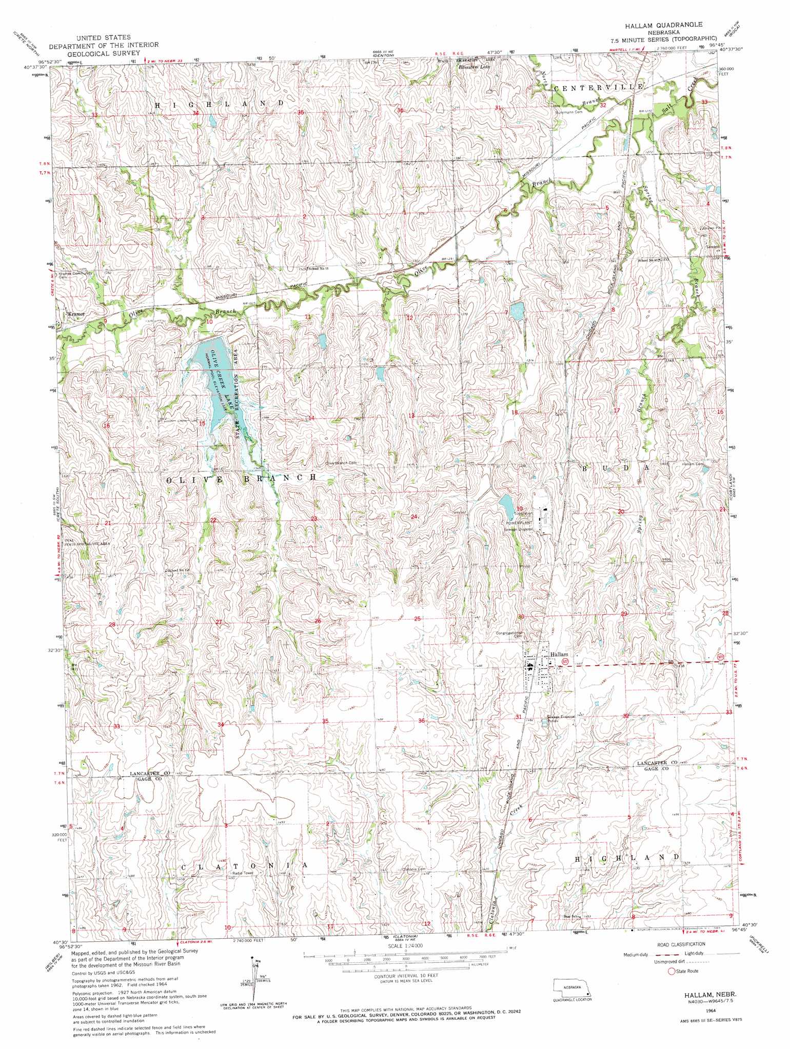
Hallam Topo Map Nebraska
To zoom in, hover over the map of Hallam
USGS Topo Quad 40096e7 - 1:24,000 scale
| Topo Map Name: | Hallam |
| USGS Topo Quad ID: | 40096e7 |
| Print Size: | ca. 21 1/4" wide x 27" high |
| Southeast Coordinates: | 40.5° N latitude / 96.75° W longitude |
| Map Center Coordinates: | 40.5625° N latitude / 96.8125° W longitude |
| U.S. State: | NE |
| Filename: | O40096e7.jpg |
| Download Map JPG Image: | Hallam topo map 1:24,000 scale |
| Map Type: | Topographic |
| Topo Series: | 7.5´ |
| Map Scale: | 1:24,000 |
| Source of Map Images: | United States Geological Survey (USGS) |
| Alternate Map Versions: |
Hallam NE 1964, updated 1965 Download PDF Buy paper map Hallam NE 2011 Download PDF Buy paper map Hallam NE 2014 Download PDF Buy paper map |
1:24,000 Topo Quads surrounding Hallam
Milford |
Pleasant Dale |
Emerald |
Lincoln |
Walton |
Dorchester |
Crete North |
Denton |
Roca |
Bennet |
Pleasant Hill |
Crete South |
Hallam |
Cortland |
Firth |
Swanton |
Wilber |
Clatonia |
Pickrell |
Adams |
Western Se |
Plymouth |
Beatrice West |
Beatrice East |
Filley |
> Back to 40096e1 at 1:100,000 scale
> Back to 40096a1 at 1:250,000 scale
> Back to U.S. Topo Maps home
Hallam topo map: Gazetteer
Hallam: Dams
Clatonia Creek Dam 10-A elevation 434m 1423′Navratil Dam elevation 422m 1384′
Olive Creek Dam-Site 2 Dam elevation 409m 1341′
Salt Creek Dam 13-A elevation 416m 1364′
Salt Creek Dam 13-B elevation 397m 1302′
Salt Creek Dam 14-1 elevation 402m 1318′
Salt Creek Dam 14-A elevation 402m 1318′
Salt Creek Dam 25-A elevation 405m 1328′
Salt Creek Dam 29-5 elevation 419m 1374′
Salt Creek Dam 5-7 elevation 416m 1364′
Salt Creek Dam 5-A elevation 403m 1322′
Salt Creek Dam 6-4 elevation 430m 1410′
Salt Creek Dam 6-A elevation 418m 1371′
Salt Creek Dam U-36 elevation 395m 1295′
Hallam: Parks
Olive Creek Lake State Recreation Area elevation 409m 1341′Hallam: Populated Places
Hallam elevation 453m 1486′Hallam: Post Offices
Hallam Post Office elevation 453m 1486′Olive Branch Post Office (historical) elevation 418m 1371′
Hallam: Reservoirs
Clatonia Creek Reservoir 10-A elevation 434m 1423′Meadow Lake Number 1 elevation 422m 1384′
Merganser Lake elevation 405m 1328′
Olive Creek Lake elevation 412m 1351′
Salt Creek Reservoir 13-A elevation 416m 1364′
Salt Creek Reservoir 13-B elevation 397m 1302′
Salt Creek Reservoir 14-1 elevation 402m 1318′
Salt Creek Reservoir 14-A elevation 402m 1318′
Salt Creek Reservoir 25-A elevation 405m 1328′
Salt Creek Reservoir 29-5 elevation 419m 1374′
Salt Creek Reservoir 5-7 elevation 416m 1364′
Salt Creek Reservoir 5-A elevation 403m 1322′
Salt Creek Reservoir 6-4 elevation 430m 1410′
Salt Creek Reservoir 6-A elevation 418m 1371′
Salt Creek Reservoir U-36 elevation 395m 1295′
Hallam: Streams
Olive Branch elevation 383m 1256′Spring Branch elevation 383m 1256′
Hallam digital topo map on disk
Buy this Hallam topo map showing relief, roads, GPS coordinates and other geographical features, as a high-resolution digital map file on DVD: