Western Sw Topo Map Nebraska
To zoom in, hover over the map of Western Sw
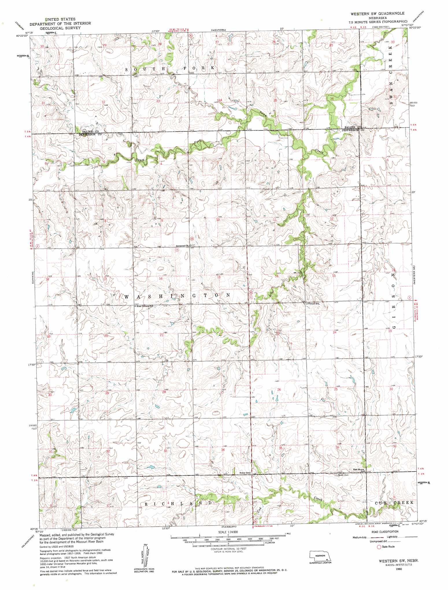
USGS Topo Quad 40097c2 - 1:24,000 scale
| Topo Map Name: | Western Sw |
| USGS Topo Quad ID: | 40097c2 |
| Print Size: | ca. 21 1/4" wide x 27" high |
| Southeast Coordinates: | 40.25° N latitude / 97.125° W longitude |
| Map Center Coordinates: | 40.3125° N latitude / 97.1875° W longitude |
| U.S. State: | NE |
| Filename: | O40097c2.jpg |
| Download Map JPG Image: | Western Sw topo map 1:24,000 scale |
| Map Type: | Topographic |
| Topo Series: | 7.5´ |
| Map Scale: | 1:24,000 |
| Source of Map Images: | United States Geological Survey (USGS) |
| Alternate Map Versions: |
Western SW NE 1960, updated 1962 Download PDF Buy paper map Western SW NE 2011 Download PDF Buy paper map Western SW NE 2014 Download PDF Buy paper map |
1:24,000 Topo Quads surrounding Western Sw
Friend Sw |
Friend Se |
Dorchester Sw |
Pleasant Hill |
Crete South |
Ohiowa |
Tobias |
Western |
Swanton |
Wilber |
Tobias Sw |
Daykin |
Western Sw |
Western Se |
Plymouth |
Alexandria |
Gladstone |
Fairbury |
Jansen |
Harbine |
Hubbell |
Reynolds |
Fairbury Sw |
Endicott |
Diller |
> Back to 40097a1 at 1:100,000 scale
> Back to 40096a1 at 1:250,000 scale
> Back to U.S. Topo Maps home
Western Sw topo map: Gazetteer
Western Sw: Dams
Cub Creek Dam 14-C elevation 434m 1423′Cub Creek Dam 17-A elevation 436m 1430′
Detention Dam 17-C elevation 437m 1433′
Floodwater Retarding Dam 15-B elevation 433m 1420′
Harold Hummel Erosion Control Dam elevation 449m 1473′
Herz Pohlmeier Dam elevation 461m 1512′
Jarchow Dam elevation 444m 1456′
Murphy Dam elevation 442m 1450′
Schwisow Dam elevation 427m 1400′
Western Sw: Populated Places
Bower (historical) elevation 446m 1463′Western Sw: Post Offices
Bower Post Office (historical) elevation 446m 1463′Western Sw: Reservoirs
Cub Creek Reservoir 14-C elevation 434m 1423′Cub Creek Reservoir 15-B elevation 433m 1420′
Cub Creek Reservoir 17-A elevation 436m 1430′
Cub Creek Reservoir 17-C elevation 437m 1433′
Herz Reservoir elevation 461m 1512′
Hummel Reservoir elevation 449m 1473′
Jarchow Reservoir elevation 444m 1456′
Murphy Reservoir elevation 442m 1450′
Schwisow Reservoir elevation 427m 1400′
Western Sw digital topo map on disk
Buy this Western Sw topo map showing relief, roads, GPS coordinates and other geographical features, as a high-resolution digital map file on DVD: