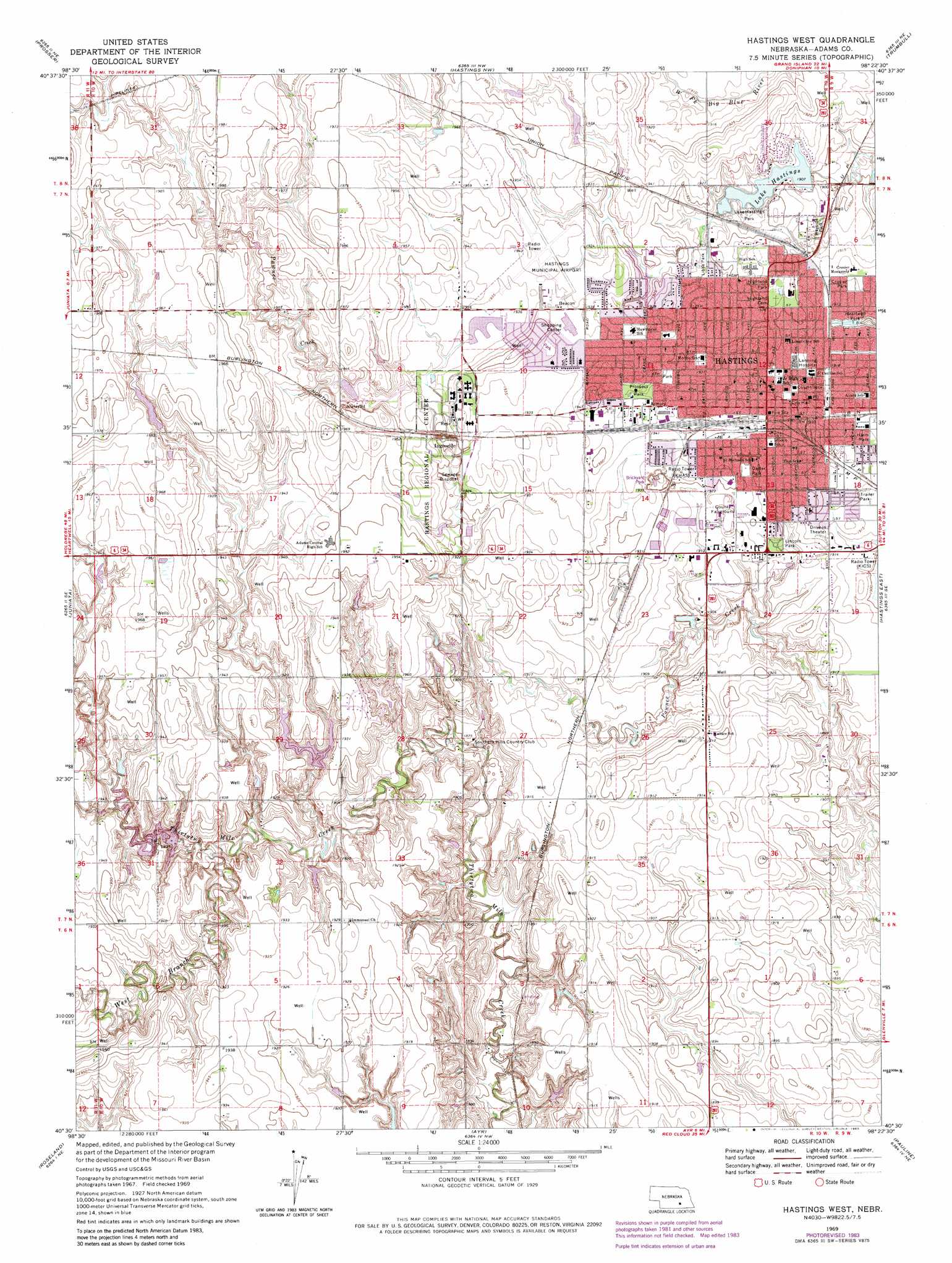
Hastings West Topo Map Nebraska
To zoom in, hover over the map of Hastings West
USGS Topo Quad 40098e4 - 1:24,000 scale
| Topo Map Name: | Hastings West |
| USGS Topo Quad ID: | 40098e4 |
| Print Size: | ca. 21 1/4" wide x 27" high |
| Southeast Coordinates: | 40.5° N latitude / 98.375° W longitude |
| Map Center Coordinates: | 40.5625° N latitude / 98.4375° W longitude |
| U.S. State: | NE |
| Filename: | O40098e4.jpg |
| Download Map JPG Image: | Hastings West topo map 1:24,000 scale |
| Map Type: | Topographic |
| Topo Series: | 7.5´ |
| Map Scale: | 1:24,000 |
| Source of Map Images: | United States Geological Survey (USGS) |
| Alternate Map Versions: |
Hastings West NE 1969, updated 1971 Download PDF Buy paper map Hastings West NE 1969, updated 1977 Download PDF Buy paper map Hastings West NE 1969, updated 1983 Download PDF Buy paper map Hastings West NE 2011 Download PDF Buy paper map Hastings West NE 2014 Download PDF Buy paper map |
1:24,000 Topo Quads surrounding Hastings West
Shelton |
Wood River |
Alda |
Doniphan |
Giltner |
Denman |
Prosser |
Hastings Nw |
Trumbull |
Harvard Nw |
Kenesaw |
Juniata |
Hastings West |
Hastings East |
Inland |
Holstein |
Roseland |
Ayr |
Pauline |
Fairfield Nw |
Campbell |
Bladen |
Blue Hill |
Lawrence |
Deweese |
> Back to 40098e1 at 1:100,000 scale
> Back to 40098a1 at 1:250,000 scale
> Back to U.S. Topo Maps home
Hastings West topo map: Gazetteer
Hastings West: Airports
Hastings Municipal Airport elevation 593m 1945′Hastings West: Dams
Hastings Dam elevation 582m 1909′Hastings Nw Dam elevation 590m 1935′
Hueske Dam elevation 581m 1906′
Thirty-Two Mile Creek Dam H elevation 578m 1896′
Thirty-Two Mile Creek Dam J elevation 584m 1916′
Trausch Bros Dam elevation 582m 1909′
Wright Dam elevation 576m 1889′
Hastings West: Lakes
Lake Hastings elevation 580m 1902′Hastings West: Parks
Alexander Park elevation 587m 1925′American Legion Park elevation 581m 1906′
Brickyard Park elevation 585m 1919′
Carter Park elevation 587m 1925′
Chatauqua Pavilion elevation 591m 1938′
Crosier Park elevation 584m 1916′
Duncan Field elevation 585m 1919′
Dutton-Lainson Plaza elevation 587m 1925′
Fisher Fountain elevation 587m 1925′
Harms Park elevation 583m 1912′
Hastings Recreation Complex elevation 584m 1916′
Heartwell Park elevation 581m 1906′
Highland Park elevation 590m 1935′
Lake Hastings Park elevation 584m 1916′
Libs Park elevation 584m 1916′
Lincoln Park elevation 583m 1912′
Oswego Park elevation 588m 1929′
Prairie Lake State Recreation Area elevation 579m 1899′
Prairie Odyssey Sculpture elevation 587m 1925′
Prairie Ridge Park elevation 584m 1916′
Prospect Park elevation 591m 1938′
Utilities Park elevation 588m 1929′
Hastings West: Populated Places
Bonnavilla and Eastgate Mobile Home Park elevation 587m 1925′Countryside Parks elevation 587m 1925′
Hastings elevation 587m 1925′
Ingleside elevation 590m 1935′
Shady Lane Trailer Court elevation 586m 1922′
Smittys Mobile Home Plaza elevation 584m 1916′
Hastings West: Post Offices
Hastings Post Office elevation 585m 1919′Hastings West: Reservoirs
Hastings Nw Reservoir elevation 590m 1935′Hueske Reservoir elevation 581m 1906′
Lake Hastings elevation 582m 1909′
Prairie Lake elevation 579m 1899′
Thirty-Two Mile Creek Reservoir elevation 584m 1916′
Thirty-Two Mile Creek Reservoir elevation 578m 1896′
Trausch Bros Reservoir elevation 582m 1909′
Wright Reservoir elevation 576m 1889′
Hastings West: Streams
West Branch Thirtytwo Mile Creek elevation 575m 1886′Hastings West digital topo map on disk
Buy this Hastings West topo map showing relief, roads, GPS coordinates and other geographical features, as a high-resolution digital map file on DVD: