Alma Topo Map Nebraska
To zoom in, hover over the map of Alma
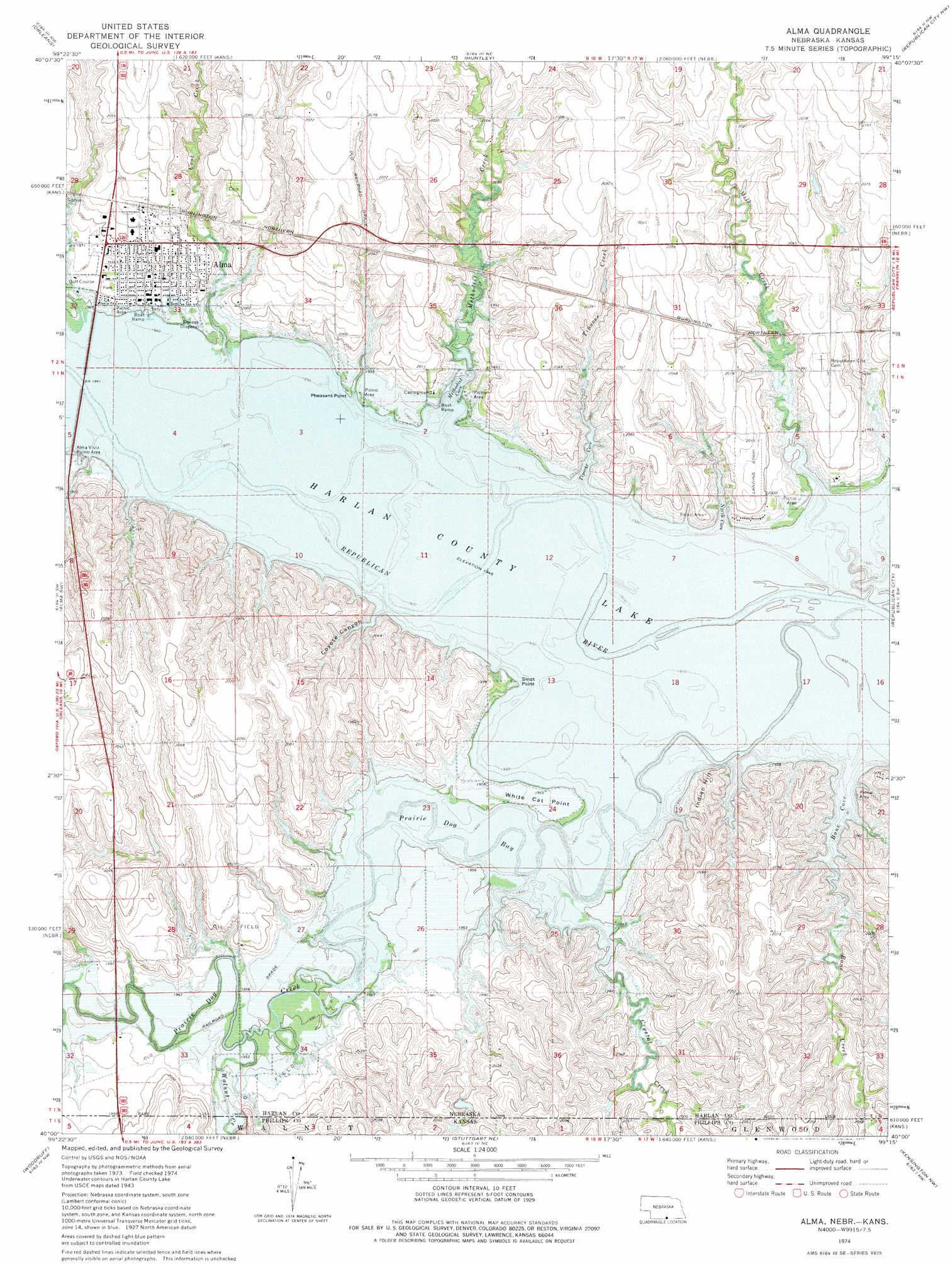
USGS Topo Quad 40099a3 - 1:24,000 scale
| Topo Map Name: | Alma |
| USGS Topo Quad ID: | 40099a3 |
| Print Size: | ca. 21 1/4" wide x 27" high |
| Southeast Coordinates: | 40° N latitude / 99.25° W longitude |
| Map Center Coordinates: | 40.0625° N latitude / 99.3125° W longitude |
| U.S. States: | NE, KS |
| Filename: | O40099a3.jpg |
| Download Map JPG Image: | Alma topo map 1:24,000 scale |
| Map Type: | Topographic |
| Topo Series: | 7.5´ |
| Map Scale: | 1:24,000 |
| Source of Map Images: | United States Geological Survey (USGS) |
| Alternate Map Versions: |
Alma NE 1974, updated 1977 Download PDF Buy paper map Alma NE 2011 Download PDF Buy paper map Alma NE 2014 Download PDF Buy paper map |
1:24,000 Topo Quads surrounding Alma
Mascot |
Atlanta |
Ragan |
Wilcox |
Hildreth |
Stamford |
Orleans |
Huntley |
Republican City Nw |
Republican City Ne |
Stamford Se |
Alma Sw |
Alma |
Republican City |
Bloomington |
Long Island |
Woodruff |
Stuttgart Ne |
Kensington Nw |
Kensington Ne |
Prairie View |
Stuttgart |
Phillipsburg North |
Gretna |
Kensington |
> Back to 40099a1 at 1:100,000 scale
> Back to 40098a1 at 1:250,000 scale
> Back to U.S. Topo Maps home
Alma topo map: Gazetteer
Alma: Airports
Alma Municipal Airport elevation 610m 2001′Harlan County Lake Seaplane Base elevation 593m 1945′
Alma: Bays
Bone Cove elevation 593m 1945′Methodist Cove elevation 593m 1945′
North Cove elevation 593m 1945′
Tipover Cove elevation 593m 1945′
Alma: Capes
Pheasant Point elevation 595m 1952′Sindt Point elevation 602m 1975′
White Cat Point elevation 596m 1955′
Alma: Parks
Alma City Park elevation 602m 1975′Alma Vista Picnic Area elevation 601m 1971′
Harlan County Lake Recreation Area elevation 593m 1945′
Alma: Populated Places
Alma elevation 602m 1975′Alma: Post Offices
Alma Post Office elevation 602m 1975′Alma: Streams
Bone Creek elevation 594m 1948′Bone Creek elevation 593m 1945′
Cook Creek elevation 594m 1948′
Crystal Creek elevation 595m 1952′
Methodist Creek elevation 594m 1948′
Mill Creek elevation 593m 1945′
Prairie Dog Bay elevation 593m 1945′
Prairie Dog Creek elevation 593m 1945′
Tipover Creek elevation 593m 1945′
Walnut Creek elevation 595m 1952′
Walnut Creek elevation 595m 1952′
Alma: Summits
Indian Hill elevation 626m 2053′Alma: Valleys
Coyote Canyon elevation 594m 1948′Alma digital topo map on disk
Buy this Alma topo map showing relief, roads, GPS coordinates and other geographical features, as a high-resolution digital map file on DVD: