Elwood Sw Topo Map Nebraska
To zoom in, hover over the map of Elwood Sw
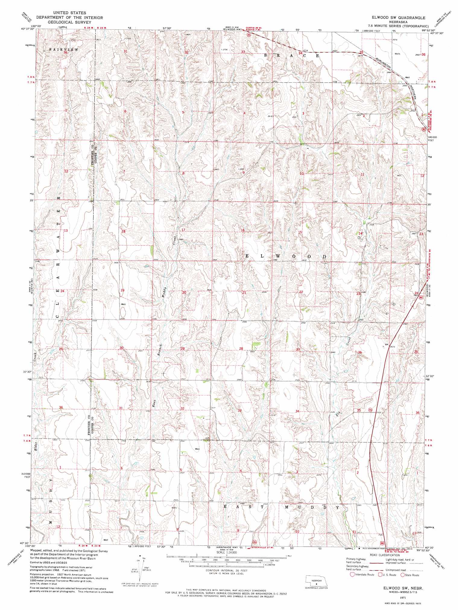
USGS Topo Quad 40099e8 - 1:24,000 scale
| Topo Map Name: | Elwood Sw |
| USGS Topo Quad ID: | 40099e8 |
| Print Size: | ca. 21 1/4" wide x 27" high |
| Southeast Coordinates: | 40.5° N latitude / 99.875° W longitude |
| Map Center Coordinates: | 40.5625° N latitude / 99.9375° W longitude |
| U.S. State: | NE |
| Filename: | O40099e8.jpg |
| Download Map JPG Image: | Elwood Sw topo map 1:24,000 scale |
| Map Type: | Topographic |
| Topo Series: | 7.5´ |
| Map Scale: | 1:24,000 |
| Source of Map Images: | United States Geological Survey (USGS) |
| Alternate Map Versions: |
Elwood SW NE 1971, updated 1973 Download PDF Buy paper map Elwood SW NE 2011 Download PDF Buy paper map Elwood SW NE 2014 Download PDF Buy paper map |
1:24,000 Topo Quads surrounding Elwood Sw
Gothenburg Sw |
Gothenburg Se |
Cozad |
Lexington West |
Lexington East |
Farnam |
Eustis |
Elwood Nw |
Johnson Lake |
Bertrand Nw |
Eustis Sw |
Eustis Se |
Elwood Sw |
Elwood |
Bertrand |
Medicine Creek Dam |
Cambridge Ne |
Arapahoe Nw |
Arapahoe Ne |
Oxford Nw |
Cambridge |
Holbrook |
Arapahoe |
Edison |
Oxford |
> Back to 40099e1 at 1:100,000 scale
> Back to 40098a1 at 1:250,000 scale
> Back to U.S. Topo Maps home
Elwood Sw topo map: Gazetteer
Elwood Sw: Dams
Brockmeier Dam elevation 755m 2477′Fader-Stewart-Hock Dam elevation 748m 2454′
Ford Dam elevation 755m 2477′
Getty Dam elevation 755m 2477′
Gruber Dam elevation 768m 2519′
McKenzie Dam elevation 775m 2542′
Schrock Dam elevation 732m 2401′
Umberger Dam elevation 773m 2536′
Elwood Sw: Reservoirs
Brockmeier Reservoir elevation 755m 2477′Fader-Stewart Reservoir elevation 748m 2454′
Ford Reservoir elevation 755m 2477′
Getty Reservoir elevation 755m 2477′
Gruber Reservoir elevation 768m 2519′
McKenzie Reservoir elevation 775m 2542′
Schrock Reservoir elevation 732m 2401′
Umberger Reservoir elevation 773m 2536′
Elwood Sw digital topo map on disk
Buy this Elwood Sw topo map showing relief, roads, GPS coordinates and other geographical features, as a high-resolution digital map file on DVD: