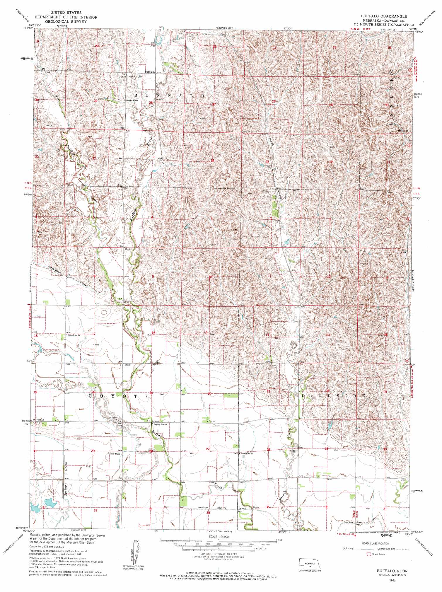
Buffalo Topo Map Nebraska
To zoom in, hover over the map of Buffalo
USGS Topo Quad 40099h7 - 1:24,000 scale
| Topo Map Name: | Buffalo |
| USGS Topo Quad ID: | 40099h7 |
| Print Size: | ca. 21 1/4" wide x 27" high |
| Southeast Coordinates: | 40.875° N latitude / 99.75° W longitude |
| Map Center Coordinates: | 40.9375° N latitude / 99.8125° W longitude |
| U.S. State: | NE |
| Filename: | O40099h7.jpg |
| Download Map JPG Image: | Buffalo topo map 1:24,000 scale |
| Map Type: | Topographic |
| Topo Series: | 7.5´ |
| Map Scale: | 1:24,000 |
| Source of Map Images: | United States Geological Survey (USGS) |
| Alternate Map Versions: |
Buffalo NE 1962, updated 1964 Download PDF Buy paper map Buffalo NE 2011 Download PDF Buy paper map Buffalo NE 2014 Download PDF Buy paper map |
1:24,000 Topo Quads surrounding Buffalo
Roten Valley North |
Oconto Nw |
Oconto |
Eddyville Nw |
Eddyville Ne |
Roten Valley South |
Oconto Sw |
Oconto Se |
Eddyville Sw |
Eddyville |
Willow Island |
Cozad Nw |
Buffalo |
Lexington Nw |
Sumner |
Gothenburg Se |
Cozad |
Lexington West |
Lexington East |
Lexington Se |
Eustis |
Elwood Nw |
Johnson Lake |
Bertrand Nw |
Overton |
> Back to 40099e1 at 1:100,000 scale
> Back to 40098a1 at 1:250,000 scale
> Back to U.S. Topo Maps home
Buffalo topo map: Gazetteer
Buffalo: Dams
Buckley Dam elevation 793m 2601′Buffalo Creek Dam B-3 elevation 782m 2565′
Buffalo Creek Dam C-5 elevation 769m 2522′
Buffalo Creek Dam F-1 elevation 764m 2506′
French Creek Dam F-3 elevation 768m 2519′
French Creek Dam F-7 elevation 784m 2572′
Jessen Dam elevation 771m 2529′
Knapple Dam elevation 762m 2500′
Mustard Detention Dam elevation 782m 2565′
Neben Dam Number 2 elevation 785m 2575′
Peden Dam Number 1 elevation 781m 2562′
Peden Dam Number 2 elevation 783m 2568′
Buffalo: Populated Places
Buffalo elevation 784m 2572′Buffalo: Post Offices
Buffalo Post Office (historical) elevation 784m 2572′Buffalo: Reservoirs
Buckley Reservoir elevation 793m 2601′Buffalo Creek Reservoir B-3 elevation 782m 2565′
Buffalo Creek Reservoir C-5 elevation 769m 2522′
Buffalo Creek Reservoir F-1 elevation 764m 2506′
French Creek Reservoir F-3 elevation 768m 2519′
French Creek Reservoir F-7 elevation 784m 2572′
Jessen Reservoir elevation 771m 2529′
Knapple Reservoir elevation 762m 2500′
Mustard Reservoir elevation 782m 2565′
Neben Reservoir Number 2 elevation 785m 2575′
Peden Reservoir Number 1 elevation 781m 2562′
Peden Reservoir Number 2 elevation 783m 2568′
Buffalo: Streams
East Buffalo Creek elevation 783m 2568′West Buffalo Creek elevation 757m 2483′
Buffalo digital topo map on disk
Buy this Buffalo topo map showing relief, roads, GPS coordinates and other geographical features, as a high-resolution digital map file on DVD: