Gothenburg Se Topo Map Nebraska
To zoom in, hover over the map of Gothenburg Se
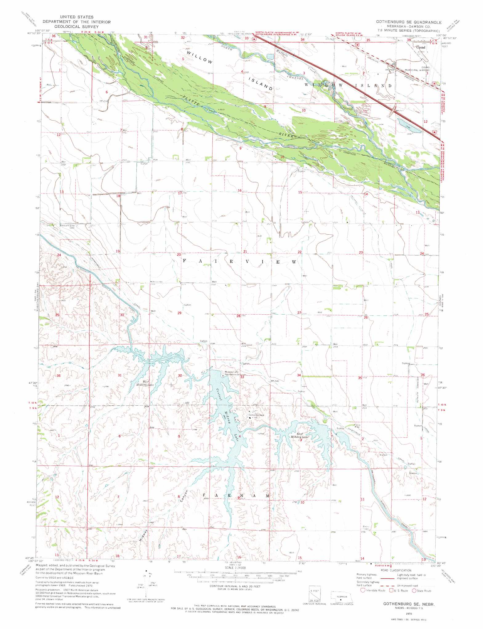
USGS Topo Quad 40100g1 - 1:24,000 scale
| Topo Map Name: | Gothenburg Se |
| USGS Topo Quad ID: | 40100g1 |
| Print Size: | ca. 21 1/4" wide x 27" high |
| Southeast Coordinates: | 40.75° N latitude / 100° W longitude |
| Map Center Coordinates: | 40.8125° N latitude / 100.0625° W longitude |
| U.S. State: | NE |
| Filename: | O40100g1.jpg |
| Download Map JPG Image: | Gothenburg Se topo map 1:24,000 scale |
| Map Type: | Topographic |
| Topo Series: | 7.5´ |
| Map Scale: | 1:24,000 |
| Source of Map Images: | United States Geological Survey (USGS) |
| Alternate Map Versions: |
Gothenburg SE NE 1970, updated 1973 Download PDF Buy paper map Gothenburg SE NE 2011 Download PDF Buy paper map Gothenburg SE NE 2014 Download PDF Buy paper map |
1:24,000 Topo Quads surrounding Gothenburg Se
Brady |
Odencranze Table South |
Roten Valley South |
Oconto Sw |
Oconto Se |
Jeffrey Reservoir Ne |
Gothenburg |
Willow Island |
Cozad Nw |
Buffalo |
Jeffrey Reservoir Se |
Gothenburg Sw |
Gothenburg Se |
Cozad |
Lexington West |
Stockville Ne |
Farnam |
Eustis |
Elwood Nw |
Johnson Lake |
Stockville Se |
Eustis Sw |
Eustis Se |
Elwood Sw |
Elwood |
> Back to 40100e1 at 1:100,000 scale
> Back to 40100a1 at 1:250,000 scale
> Back to U.S. Topo Maps home
Gothenburg Se topo map: Gazetteer
Gothenburg Se: Airports
Cozad Municipal Airport elevation 762m 2500′Gothenburg Se: Canals
Orchard Alfalfa Canal elevation 764m 2506′Gothenburg Se: Dams
Earth Dam-Canal Mile 461 Dam elevation 784m 2572′Earth Dam-Canal Mile 475 Dam elevation 782m 2565′
Earth Dam-Canal Mile 479 Dam elevation 811m 2660′
Earth Dam-Canal Mile 483 Dam elevation 785m 2575′
Earth Dam-Canal Mile 505 Dam elevation 794m 2604′
Earth Dam-Canal Mile 51 Dam elevation 782m 2565′
Earth Dam-Canal Mile 515 Dam elevation 801m 2627′
Earth Dam-Canal Mile 52 Dam elevation 796m 2611′
Gothenburg Se: Parks
East Willow Island State Wildlife Management Area elevation 765m 2509′Midway Lake Recreational Grounds elevation 807m 2647′
West Cozad State Wildlife Management Area elevation 760m 2493′
Gothenburg Se: Reservoirs
Central Midway Lake elevation 804m 2637′East Midway Lake elevation 803m 2634′
West Cozad Lake elevation 760m 2493′
West Midway Lake elevation 802m 2631′
Gothenburg Se: Streams
Buffalo Creek elevation 763m 2503′Gothenburg Se: Valleys
Midway Canyon elevation 803m 2634′Gothenburg Se digital topo map on disk
Buy this Gothenburg Se topo map showing relief, roads, GPS coordinates and other geographical features, as a high-resolution digital map file on DVD: