Hoyt Topo Map Colorado
To zoom in, hover over the map of Hoyt
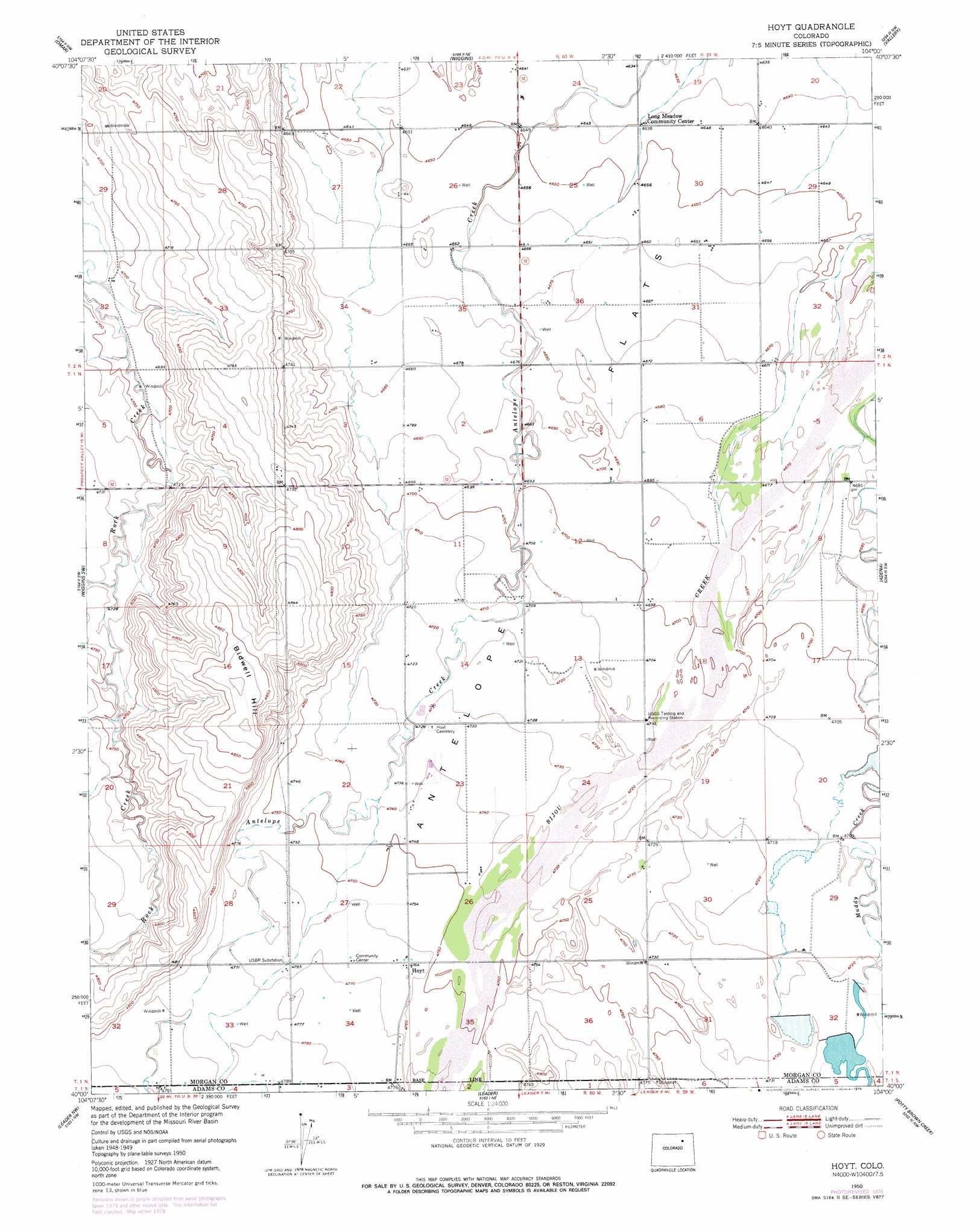
USGS Topo Quad 40104a1 - 1:24,000 scale
| Topo Map Name: | Hoyt |
| USGS Topo Quad ID: | 40104a1 |
| Print Size: | ca. 21 1/4" wide x 27" high |
| Southeast Coordinates: | 40° N latitude / 104° W longitude |
| Map Center Coordinates: | 40.0625° N latitude / 104.0625° W longitude |
| U.S. State: | CO |
| Filename: | o40104a1.jpg |
| Download Map JPG Image: | Hoyt topo map 1:24,000 scale |
| Map Type: | Topographic |
| Topo Series: | 7.5´ |
| Map Scale: | 1:24,000 |
| Source of Map Images: | United States Geological Survey (USGS) |
| Alternate Map Versions: |
Hoyt CO 1950, updated 1972 Download PDF Buy paper map Hoyt CO 1950, updated 1972 Download PDF Buy paper map Hoyt CO 1950, updated 1977 Download PDF Buy paper map Hoyt CO 1950, updated 1979 Download PDF Buy paper map Hoyt CO 1951 Download PDF Buy paper map Hoyt CO 1951 Download PDF Buy paper map Hoyt CO 2010 Download PDF Buy paper map Hoyt CO 2013 Download PDF Buy paper map Hoyt CO 2016 Download PDF Buy paper map |
1:24,000 Topo Quads surrounding Hoyt
Dearfield |
Masters |
Orchard |
Weldona |
Fort Morgan |
Roggen |
Omar |
Wiggins |
Vallery |
Lamb |
South Roggen |
Wiggins Sw |
Hoyt |
Adena |
Vallery Se |
Living Springs |
Leader Nw |
Leader |
Potty Brown Creek |
Shamrock |
Roper School |
Leader Sw |
Leader Se |
Poison Springs |
Shamrock Se |
> Back to 40104a1 at 1:100,000 scale
> Back to 40104a1 at 1:250,000 scale
> Back to U.S. Topo Maps home
Hoyt topo map: Gazetteer
Hoyt: Dams
Baseline Dam elevation 1443m 4734′Hoyt: Populated Places
Hoyt elevation 1452m 4763′Hoyt: Reservoirs
Baseline Reservoir elevation 1443m 4734′Moore Reservoir Number 4 elevation 1446m 4744′
Hoyt: Streams
Little Antelope Creek elevation 1459m 4786′Hoyt: Summits
Bidwell Hill elevation 1486m 4875′Hoyt digital topo map on disk
Buy this Hoyt topo map showing relief, roads, GPS coordinates and other geographical features, as a high-resolution digital map file on DVD: