Severance Topo Map Colorado
To zoom in, hover over the map of Severance
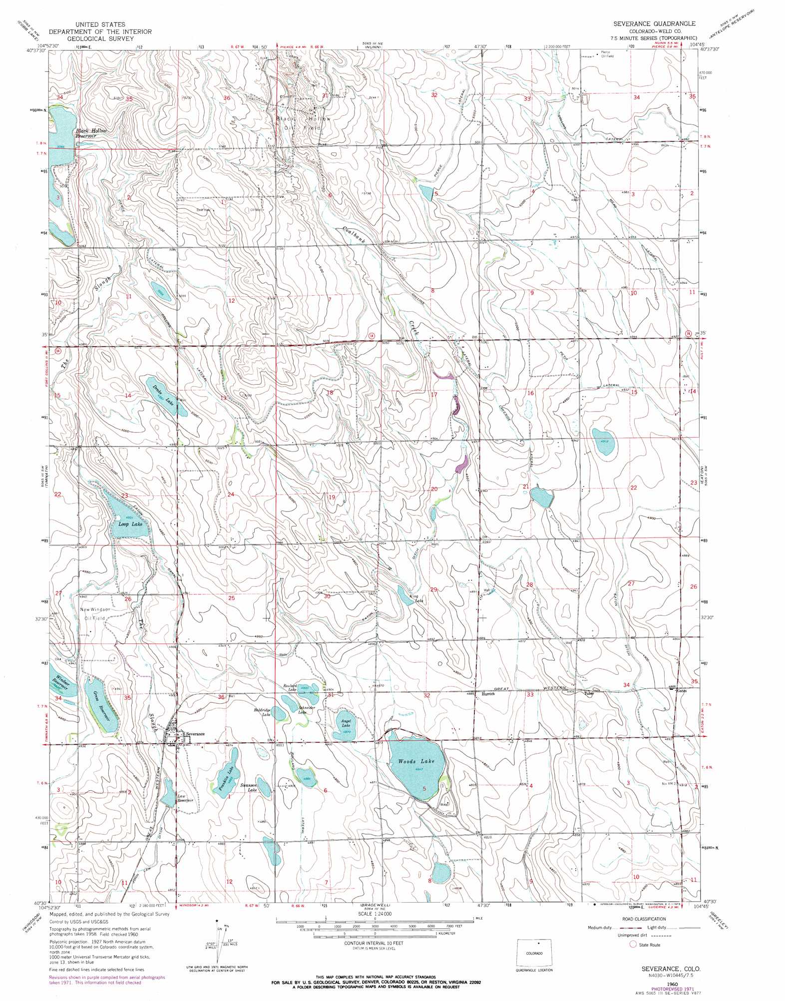
USGS Topo Quad 40104e7 - 1:24,000 scale
| Topo Map Name: | Severance |
| USGS Topo Quad ID: | 40104e7 |
| Print Size: | ca. 21 1/4" wide x 27" high |
| Southeast Coordinates: | 40.5° N latitude / 104.75° W longitude |
| Map Center Coordinates: | 40.5625° N latitude / 104.8125° W longitude |
| U.S. State: | CO |
| Filename: | o40104e7.jpg |
| Download Map JPG Image: | Severance topo map 1:24,000 scale |
| Map Type: | Topographic |
| Topo Series: | 7.5´ |
| Map Scale: | 1:24,000 |
| Source of Map Images: | United States Geological Survey (USGS) |
| Alternate Map Versions: |
Severance CO 1960, updated 1962 Download PDF Buy paper map Severance CO 1960, updated 1973 Download PDF Buy paper map Severance CO 1960, updated 1973 Download PDF Buy paper map Severance CO 2010 Download PDF Buy paper map Severance CO 2013 Download PDF Buy paper map Severance CO 2016 Download PDF Buy paper map |
1:24,000 Topo Quads surrounding Severance
Buckeye |
Carr Sw |
Dover |
Eastman Creek South |
Eastman Creek Se |
Wellington |
Cobb Lake |
Nunn |
Antelope Reservoir |
Purcell |
Fort Collins |
Timnath |
Severance |
Eaton |
Galeton |
Loveland |
Windsor |
Bracewell |
Greeley |
Kersey |
Berthoud |
Johnstown |
Milliken |
La Salle |
Valley View School |
> Back to 40104e1 at 1:100,000 scale
> Back to 40104a1 at 1:250,000 scale
> Back to U.S. Topo Maps home
Severance topo map: Gazetteer
Severance: Canals
Collins Lateral elevation 1533m 5029′John Law Ditch elevation 1476m 4842′
Lakeside Lateral elevation 1526m 5006′
Petit Lateral elevation 1510m 4954′
Pierce Lateral elevation 1545m 5068′
Roulard Lateral elevation 1492m 4895′
Severance: Dams
Angel Lake Dam elevation 1490m 4888′Black Hollow Dam elevation 1546m 5072′
Eaton-Law Dam elevation 1501m 4924′
John Law Dam elevation 1482m 4862′
Loup Lake Dam elevation 1503m 4931′
Wood Dam elevation 1478m 4849′
Wykert Number 1 Dam elevation 1526m 5006′
Wykert Number 2 Dam elevation 1518m 4980′
Wykert Number 4 Dam elevation 1504m 4934′
Severance: Oilfields
Black Hollow Oil Field elevation 1563m 5127′New Windsor Oil Field elevation 1501m 4924′
Severance: Populated Places
Gates elevation 1490m 4888′Hurrich elevation 1490m 4888′
Severance elevation 1490m 4888′
Severance: Reservoirs
Angel Lake elevation 1485m 4872′Baldridge Lake elevation 1493m 4898′
Black Hollow Reservoir elevation 1546m 5072′
Drake Lake elevation 1524m 5000′
Eaton-Law Reservoir elevation 1501m 4924′
Franklin Lake elevation 1485m 4872′
Gress Reservoir elevation 1500m 4921′
John Law Reservoir elevation 1482m 4862′
King Lake elevation 1497m 4911′
Law Reservoir elevation 1482m 4862′
Loop Lake elevation 1503m 4931′
Loup Lake elevation 1503m 4931′
Roulard Lake elevation 1494m 4901′
Schneider Lake elevation 1496m 4908′
Swanson Lake elevation 1488m 4881′
Woods Lake elevation 1479m 4852′
Wykert Number 4 Reservoir elevation 1504m 4934′
Wykert Reservoir Number 1 elevation 1526m 5006′
Wykert Reservoir Number 2 elevation 1518m 4980′
Severance: Streams
Coalbank Creek elevation 1501m 4924′The Slough elevation 1482m 4862′
Severance digital topo map on disk
Buy this Severance topo map showing relief, roads, GPS coordinates and other geographical features, as a high-resolution digital map file on DVD: