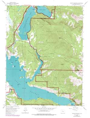
Shadow Mountain Topo Map Colorado
To zoom in, hover over the map of Shadow Mountain
USGS Topo Quad 40105b7 - 1:24,000 scale
| Topo Map Name: | Shadow Mountain |
| USGS Topo Quad ID: | 40105b7 |
| Print Size: | ca. 21 1/4" wide x 27" high |
| Southeast Coordinates: | 40.125° N latitude / 105.75° W longitude |
| Map Center Coordinates: | 40.1875° N latitude / 105.8125° W longitude |
| U.S. State: | CO |
| Filename: | o40105b7.jpg |
| Download Map JPG Image: | Shadow Mountain topo map 1:24,000 scale |
| Map Type: | Topographic |
| Topo Series: | 7.5´ |
| Map Scale: | 1:24,000 |
| Source of Map Images: | United States Geological Survey (USGS) |
| Alternate Map Versions: |
Shadow Mountain CO 1958, updated 1959 Download PDF Buy paper map Shadow Mountain CO 1958, updated 1966 Download PDF Buy paper map Shadow Mountain CO 1958, updated 1975 Download PDF Buy paper map Shadow Mountain CO 1958, updated 1978 Download PDF Buy paper map Shadow Mountain CO 2011 Download PDF Buy paper map Shadow Mountain CO 2013 Download PDF Buy paper map Shadow Mountain CO 2016 Download PDF Buy paper map |
| FStopo: | US Forest Service topo Shadow Mountain is available: Download FStopo PDF Download FStopo TIF |
1:24,000 Topo Quads surrounding Shadow Mountain
> Back to 40105a1 at 1:100,000 scale
> Back to 40104a1 at 1:250,000 scale
> Back to U.S. Topo Maps home
Shadow Mountain topo map: Gazetteer
Shadow Mountain: Bays
Columbine Bay elevation 2525m 8284′Grand Bay elevation 2525m 8284′
Hidden Cove elevation 2525m 8284′
Kamloop Cove elevation 2525m 8284′
McDonald Cove elevation 2525m 8284′
Petes Cove elevation 2525m 8284′
Shadow Mountain: Beaches
Surprise Beach elevation 2533m 8310′Shadow Mountain: Canals
Granby Pump Canal elevation 2561m 8402′Lehman Ditch elevation 2575m 8448′
Shadow Mountain: Capes
Inspiration Point elevation 2547m 8356′Rocky Point elevation 2547m 8356′
Sunset Point elevation 2528m 8293′
Twin Pines Point elevation 2538m 8326′
Shadow Mountain: Dams
Granby Dam elevation 2525m 8284′Granby Dike Number 3 Dam elevation 2525m 8284′
Shadow Mountain Dam elevation 2548m 8359′
Shadow Mountain: Falls
Adams Falls elevation 2584m 8477′Shadow Mountain: Islands
Deer Island elevation 2525m 8284′Elephant Island elevation 2525m 8284′
Gull Island elevation 2526m 8287′
Harvey Island elevation 2542m 8339′
Rainbow Island elevation 2545m 8349′
Shelter Island elevation 2540m 8333′
Shadow Mountain: Parks
Shadow Mountain National Recreation Area elevation 2615m 8579′Shadow Mountain: Reservoirs
Grand Lake elevation 2552m 8372′Lake Granby elevation 2525m 8284′
Shadow Mountain Lake elevation 2548m 8359′
Shadow Mountain: Ridges
Green Ridge elevation 2748m 9015′Knight Ridge elevation 2753m 9032′
Shadow Mountain: Streams
Columbine Creek elevation 2525m 8284′East Inlet elevation 2552m 8372′
Echo Creek elevation 2598m 8523′
Grouse Creek elevation 2528m 8293′
Little Columbine Creek elevation 2552m 8372′
North Inlet elevation 2552m 8372′
Pole Creek elevation 2530m 8300′
Ranger Creek elevation 2539m 8330′
Roaring Fork Arapaho Creek elevation 2527m 8290′
Supply Creek elevation 2581m 8467′
Twin Creek elevation 2526m 8287′
Shadow Mountain: Summits
Mount Acoma elevation 3188m 10459′Mount Bryant elevation 3359m 11020′
Mount Wescott elevation 3179m 10429′
Shadow Mountain elevation 3087m 10127′
Twin Peaks elevation 3639m 11938′
Shadow Mountain: Trails
Columbine Creek Trail elevation 2694m 8838′East Inlet Trail elevation 2788m 9146′
Outlet Trail elevation 2585m 8480′
Shadow Mountain Trail elevation 2821m 9255′
Shadow Mountain: Valleys
Walden Hollow elevation 2458m 8064′Shadow Mountain digital topo map on disk
Buy this Shadow Mountain topo map showing relief, roads, GPS coordinates and other geographical features, as a high-resolution digital map file on DVD:


