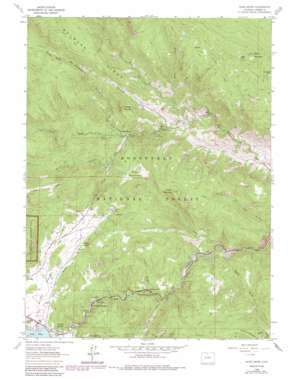
Glen Haven Topo Map Colorado
To zoom in, hover over the map of Glen Haven
USGS Topo Quad 40105d4 - 1:24,000 scale
| Topo Map Name: | Glen Haven |
| USGS Topo Quad ID: | 40105d4 |
| Print Size: | ca. 21 1/4" wide x 27" high |
| Southeast Coordinates: | 40.375° N latitude / 105.375° W longitude |
| Map Center Coordinates: | 40.4375° N latitude / 105.4375° W longitude |
| U.S. State: | CO |
| Filename: | o40105d4.jpg |
| Download Map JPG Image: | Glen Haven topo map 1:24,000 scale |
| Map Type: | Topographic |
| Topo Series: | 7.5´ |
| Map Scale: | 1:24,000 |
| Source of Map Images: | United States Geological Survey (USGS) |
| Alternate Map Versions: |
Glen Haven CO 1962, updated 1964 Download PDF Buy paper map Glen Haven CO 1962, updated 1971 Download PDF Buy paper map Glen Haven CO 1962, updated 1971 Download PDF Buy paper map Glen Haven CO 1962, updated 1980 Download PDF Buy paper map Glen Haven CO 1962, updated 1985 Download PDF Buy paper map Glen Haven CO 1962, updated 1985 Download PDF Buy paper map Glen Haven CO 2011 Download PDF Buy paper map Glen Haven CO 2013 Download PDF Buy paper map Glen Haven CO 2016 Download PDF Buy paper map |
| FStopo: | US Forest Service topo Glen Haven is available: Download FStopo PDF Download FStopo TIF |
1:24,000 Topo Quads surrounding Glen Haven
> Back to 40105a1 at 1:100,000 scale
> Back to 40104a1 at 1:250,000 scale
> Back to U.S. Topo Maps home
Glen Haven topo map: Gazetteer
Glen Haven: Dams
Olympus Dam elevation 2280m 7480′Glen Haven: Flats
Estes Park elevation 2333m 7654′Foggy Park elevation 2871m 9419′
Piper Meadows elevation 2422m 7946′
Glen Haven: Lakes
Donath Lake elevation 2368m 7769′Glen Haven: Mines
Hideabove Mine elevation 2975m 9760′Lewis Beryl Mine elevation 2922m 9586′
New Hope Claims elevation 2570m 8431′
Glen Haven: Pillars
Eagle Rock elevation 2574m 8444′Glen Haven: Populated Places
Glen Comfort elevation 2189m 7181′Glen Haven elevation 2200m 7217′
Loveland Heights elevation 2226m 7303′
Olympus Heights elevation 2292m 7519′
Glen Haven: Post Offices
Glen Haven Post Office (historical) elevation 2200m 7217′Glen Haven: Reservoirs
Lake Estes elevation 2278m 7473′Glen Haven: Ridges
Bulwark Ridge elevation 2778m 9114′Glen Haven: Streams
Black Creek elevation 2141m 7024′Cow Creek elevation 2343m 7687′
Fossil Creek elevation 2570m 8431′
Miller Fork elevation 2108m 6916′
Solitude Creek elevation 2271m 7450′
West Creek elevation 2199m 7214′
Glen Haven: Summits
Crosier Mountain elevation 2809m 9215′Storm Mountain elevation 3015m 9891′
Sugarloaf Mountain elevation 2722m 8930′
Triangle Mountain elevation 2560m 8398′
Glen Haven: Trails
Crosier Mountain Trail elevation 2433m 7982′Indian Trail elevation 2503m 8211′
Storm Mountain Trail elevation 2586m 8484′
Glen Haven: Tunnels
Olympus Tunnel elevation 2592m 8503′Glen Haven: Valleys
Dark Gulch elevation 2184m 7165′Devils Gulch elevation 2200m 7217′
Dry Gulch elevation 2275m 7463′
Dunraven Glade elevation 2131m 6991′
Long Gulch elevation 2105m 6906′
Noels Draw elevation 2178m 7145′
Rabbit Gulch elevation 2121m 6958′
Glen Haven digital topo map on disk
Buy this Glen Haven topo map showing relief, roads, GPS coordinates and other geographical features, as a high-resolution digital map file on DVD:


