Pingree Park Topo Map Colorado
To zoom in, hover over the map of Pingree Park
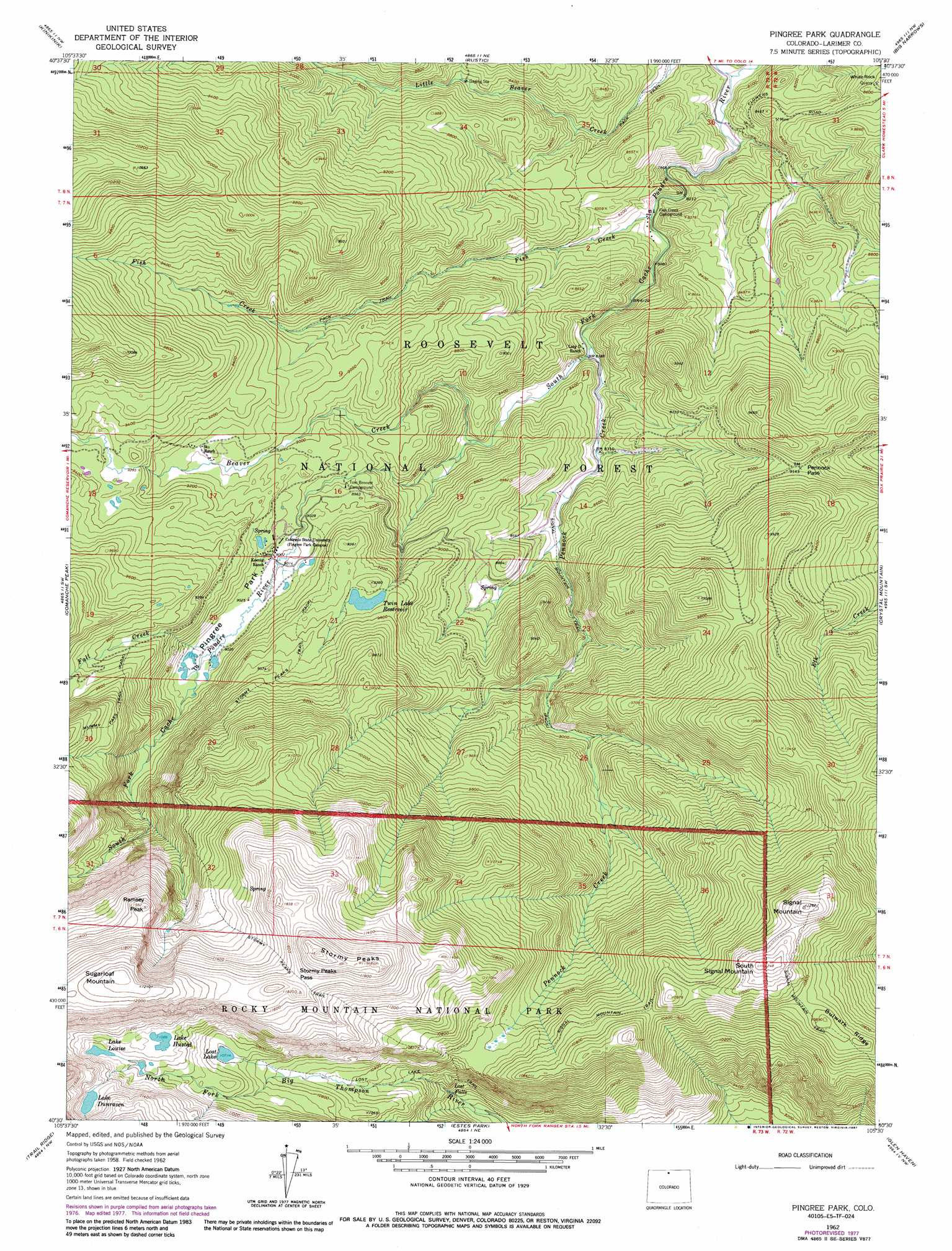
USGS Topo Quad 40105e5 - 1:24,000 scale
| Topo Map Name: | Pingree Park |
| USGS Topo Quad ID: | 40105e5 |
| Print Size: | ca. 21 1/4" wide x 27" high |
| Southeast Coordinates: | 40.5° N latitude / 105.5° W longitude |
| Map Center Coordinates: | 40.5625° N latitude / 105.5625° W longitude |
| U.S. State: | CO |
| Filename: | o40105e5.jpg |
| Download Map JPG Image: | Pingree Park topo map 1:24,000 scale |
| Map Type: | Topographic |
| Topo Series: | 7.5´ |
| Map Scale: | 1:24,000 |
| Source of Map Images: | United States Geological Survey (USGS) |
| Alternate Map Versions: |
Pingree Park CO 1962, updated 1964 Download PDF Buy paper map Pingree Park CO 1962, updated 1969 Download PDF Buy paper map Pingree Park CO 1962, updated 1978 Download PDF Buy paper map Pingree Park CO 1962, updated 1987 Download PDF Buy paper map Pingree Park CO 2011 Download PDF Buy paper map Pingree Park CO 2013 Download PDF Buy paper map Pingree Park CO 2016 Download PDF Buy paper map |
| FStopo: | US Forest Service topo Pingree Park is available: Download FStopo PDF Download FStopo TIF |
1:24,000 Topo Quads surrounding Pingree Park
Deadman |
South Bald Mountain |
Red Feather Lakes |
Haystack Gulch |
Livermore Mountain |
Boston Peak |
Kinikinik |
Rustic |
Big Narrows |
Poudre Park |
Chambers Lake |
Comanche Peak |
Pingree Park |
Crystal Mountain |
Buckhorn Mountain |
Fall River Pass |
Trail Ridge |
Estes Park |
Glen Haven |
Drake |
Grand Lake |
Mchenrys Peak |
Longs Peak |
Panorama Peak |
Pinewood Lake |
> Back to 40105e1 at 1:100,000 scale
> Back to 40104a1 at 1:250,000 scale
> Back to U.S. Topo Maps home
Pingree Park topo map: Gazetteer
Pingree Park: Dams
Glacier Number 1 Dam elevation 3270m 10728′Pennock Creek Dam elevation 2839m 9314′
Pingree Park: Falls
Lost Falls elevation 3000m 9842′Pingree Park: Flats
Pingree Park elevation 2749m 9019′Pingree Park: Gaps
Stormy Peaks Pass elevation 3557m 11669′Pingree Park: Lakes
Lake Dunraven elevation 3438m 11279′Lake Husted elevation 3381m 11092′
Lake Louise elevation 3365m 11040′
Latman Lake elevation 3081m 10108′
Lost Lake elevation 3267m 10718′
Pingree Park: Reservoirs
Glacier Number 1 Reservoir elevation 3270m 10728′Pennock Creek Reservoir elevation 2839m 9314′
Twin Lake Reservoir elevation 2839m 9314′
Pingree Park: Streams
Beaver Creek elevation 2693m 8835′Fall Creek elevation 2750m 9022′
Fish Creek elevation 2450m 8038′
Little Beaver Creek elevation 2401m 7877′
Pennock Creek elevation 2493m 8179′
Pingree Park: Summits
Ramsey Peak elevation 3524m 11561′Signal Mountain elevation 3430m 11253′
South Signal Mountain elevation 3426m 11240′
Stormy Peaks elevation 3692m 12112′
Sugarloaf Mountain elevation 3701m 12142′
Pingree Park: Trails
Lost Lake Trail elevation 3073m 10082′Signal Mountain Trail elevation 3352m 10997′
Stormy Peaks Trail elevation 3121m 10239′
Pingree Park digital topo map on disk
Buy this Pingree Park topo map showing relief, roads, GPS coordinates and other geographical features, as a high-resolution digital map file on DVD: