Laporte Topo Map Colorado
To zoom in, hover over the map of Laporte
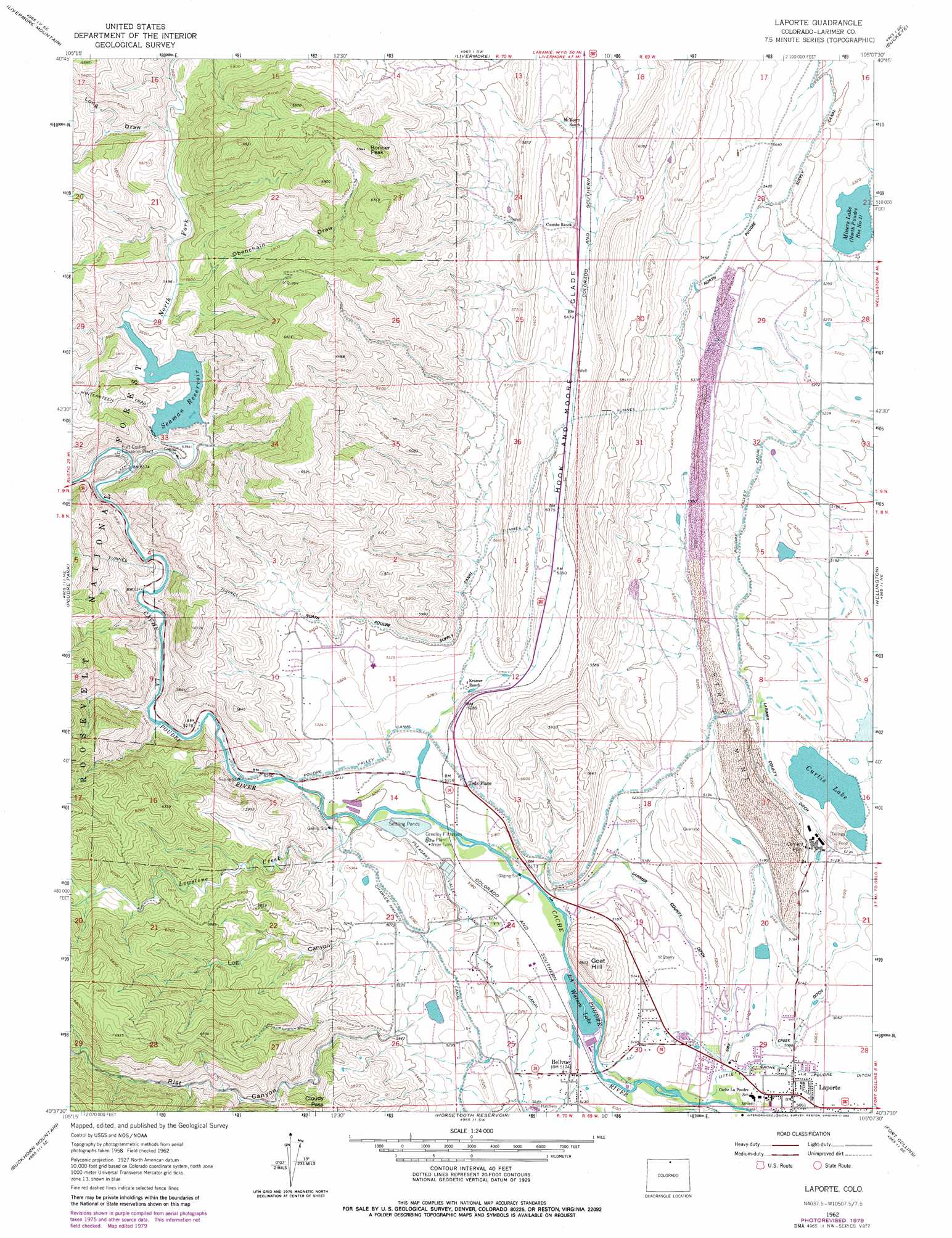
USGS Topo Quad 40105f2 - 1:24,000 scale
| Topo Map Name: | Laporte |
| USGS Topo Quad ID: | 40105f2 |
| Print Size: | ca. 21 1/4" wide x 27" high |
| Southeast Coordinates: | 40.625° N latitude / 105.125° W longitude |
| Map Center Coordinates: | 40.6875° N latitude / 105.1875° W longitude |
| U.S. State: | CO |
| Filename: | o40105f2.jpg |
| Download Map JPG Image: | Laporte topo map 1:24,000 scale |
| Map Type: | Topographic |
| Topo Series: | 7.5´ |
| Map Scale: | 1:24,000 |
| Source of Map Images: | United States Geological Survey (USGS) |
| Alternate Map Versions: |
Laporte CO 1962, updated 1964 Download PDF Buy paper map Laporte CO 1962, updated 1969 Download PDF Buy paper map Laporte CO 1962, updated 1969 Download PDF Buy paper map LaPorte CO 1962, updated 1980 Download PDF Buy paper map Laporte CO 2011 Download PDF Buy paper map Laporte CO 2013 Download PDF Buy paper map Laporte CO 2016 Download PDF Buy paper map |
| FStopo: | US Forest Service topo Laporte is available: Download FStopo PDF Download FStopo TIF |
1:24,000 Topo Quads surrounding Laporte
Cherokee Park |
Virginia Dale |
Table Mountain |
Round Butte |
Carr West |
Haystack Gulch |
Livermore Mountain |
Livermore |
Buckeye |
Carr Sw |
Big Narrows |
Poudre Park |
Laporte |
Wellington |
Cobb Lake |
Crystal Mountain |
Buckhorn Mountain |
Horsetooth Reservoir |
Fort Collins |
Timnath |
Glen Haven |
Drake |
Masonville |
Loveland |
Windsor |
> Back to 40105e1 at 1:100,000 scale
> Back to 40104a1 at 1:250,000 scale
> Back to U.S. Topo Maps home
Laporte topo map: Gazetteer
Laporte: Canals
Charles Hansen Canal elevation 1603m 5259′Munroe Gravity Canal elevation 1649m 5410′
Poudre Valley Canal elevation 1598m 5242′
Laporte: Dams
Curtis Lake Dam elevation 1558m 5111′Milton Seaman Dam elevation 1671m 5482′
North Poudre Number 1 Dam elevation 1615m 5298′
Watson Lake Dam elevation 1558m 5111′
Laporte: Flats
Hook and Moore Glade elevation 1667m 5469′Laporte: Gaps
Cloudy Pass elevation 1807m 5928′Laporte: Lakes
Watson Lake elevation 1558m 5111′Laporte: Mines
Challenger Mine elevation 1573m 5160′Echo Glen Mine elevation 1955m 6414′
Treasure Hill Mine elevation 1974m 6476′
Wahketa Lease Mine elevation 1847m 6059′
Laporte: Populated Places
Bellvue elevation 1565m 5134′Laporte elevation 1543m 5062′
Laporte: Reservoirs
Curtis Lake elevation 1559m 5114′Curtis Lake Reservoir elevation 1558m 5111′
Milton Seaman Reservoir elevation 1671m 5482′
Miners Lake elevation 1616m 5301′
North Poudre Reservoir Number 1 elevation 1615m 5298′
Seaman Reservoir elevation 1671m 5482′
Laporte: Streams
Lewstone Creek elevation 1585m 5200′North Fork Cache La Poudre River elevation 1633m 5357′
Owl Creek elevation 1623m 5324′
Laporte: Summits
Bonner Peak elevation 2113m 6932′Goat Hill elevation 1708m 5603′
Laporte: Valleys
Log Canyon elevation 1583m 5193′Long Draw elevation 1701m 5580′
Long Gulch elevation 1556m 5104′
Obenchain Draw elevation 1679m 5508′
Rist Canyon elevation 1639m 5377′
Laporte digital topo map on disk
Buy this Laporte topo map showing relief, roads, GPS coordinates and other geographical features, as a high-resolution digital map file on DVD: