Hot Sulpher Springs Topo Map Colorado
To zoom in, hover over the map of Hot Sulpher Springs
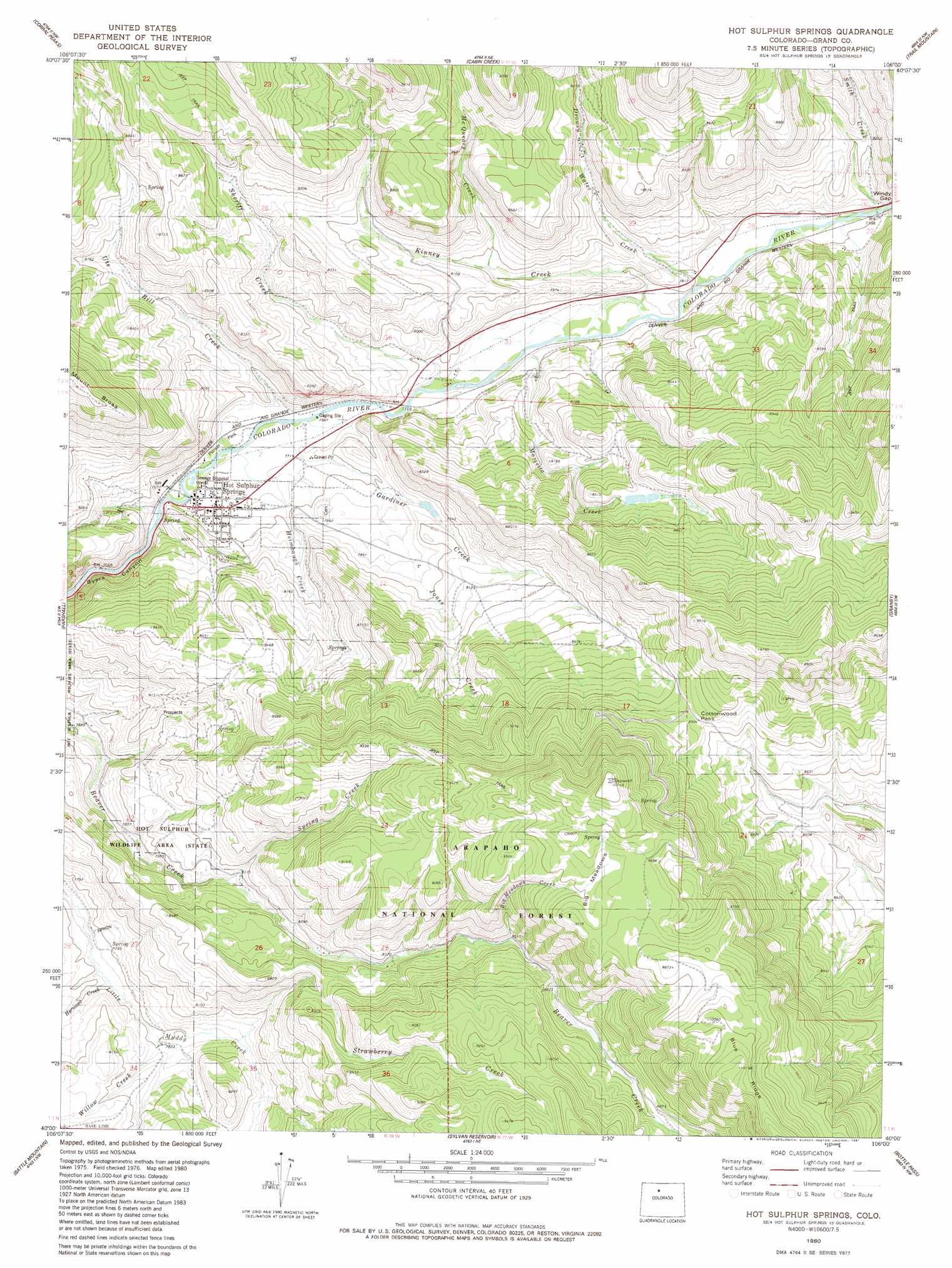
USGS Topo Quad 40106a1 - 1:24,000 scale
| Topo Map Name: | Hot Sulpher Springs |
| USGS Topo Quad ID: | 40106a1 |
| Print Size: | ca. 21 1/4" wide x 27" high |
| Southeast Coordinates: | 40° N latitude / 106° W longitude |
| Map Center Coordinates: | 40.0625° N latitude / 106.0625° W longitude |
| U.S. State: | CO |
| Filename: | o40106a1.jpg |
| Download Map JPG Image: | Hot Sulpher Springs topo map 1:24,000 scale |
| Map Type: | Topographic |
| Topo Series: | 7.5´ |
| Map Scale: | 1:24,000 |
| Source of Map Images: | United States Geological Survey (USGS) |
| Alternate Map Versions: |
Hot Sulphur Springs CO 1980, updated 1981 Download PDF Buy paper map Hot Sulphur Springs CO 1980, updated 1981 Download PDF Buy paper map Hot Sulphur Springs CO 2011 Download PDF Buy paper map Hot Sulphur Springs CO 2013 Download PDF Buy paper map Hot Sulphur Springs CO 2016 Download PDF Buy paper map |
| FStopo: | US Forest Service topo Hot Sulphur Springs is available: Download FStopo PDF Download FStopo TIF |
1:24,000 Topo Quads surrounding Hot Sulpher Springs
Hyannis Peak |
Parkview Mountain |
Radial Mountain |
Bowen Mountain |
Grand Lake |
Gunsight Pass |
Corral Peaks |
Cabin Creek |
Trail Mountain |
Shadow Mountain |
Junction Butte |
Parshall |
Hot Sulpher Springs |
Granby |
Strawberry Lake |
King Creek |
Battle Mountain |
Sylvan Reservoir |
Bottle Pass |
Fraser |
Mount Powell |
Squaw Creek |
Ute Peak |
Byers Peak |
Berthoud Pass |
> Back to 40106a1 at 1:100,000 scale
> Back to 40106a1 at 1:250,000 scale
> Back to U.S. Topo Maps home
Hot Sulpher Springs topo map: Gazetteer
Hot Sulpher Springs: Dams
Cottonwood Dam elevation 2416m 7926′Huntington Dam elevation 2419m 7936′
Hot Sulpher Springs: Flats
Big Meadows elevation 2936m 9632′Hot Sulpher Springs: Gaps
Cottonwood Pass elevation 2718m 8917′Windy Gap elevation 2442m 8011′
Hot Sulpher Springs: Parks
Hot Sulphur State Wildlife Area elevation 2368m 7769′Pioneer Park elevation 2341m 7680′
Hot Sulpher Springs: Populated Places
Hot Sulphur Springs elevation 2356m 7729′Hot Sulpher Springs: Reservoirs
Cottonwood Reservoir elevation 2416m 7926′Huntington Reservoir elevation 2419m 7936′
Hot Sulpher Springs: Springs
Hot Sulphur Springs elevation 2355m 7726′Hot Sulpher Springs: Streams
Big Meadows Creek elevation 2593m 8507′Drowsy Water Creek elevation 2367m 7765′
Gardiner Creek elevation 2343m 7687′
Heimbaugh Creek elevation 2343m 7687′
Hermosa Creek elevation 2364m 7755′
Jones Creek elevation 2383m 7818′
Kinney Creek elevation 2363m 7752′
Marietta Creek elevation 2384m 7821′
McQueary Creek elevation 2429m 7969′
Sheriff Creek elevation 2352m 7716′
Smith Creek elevation 2381m 7811′
Spring Creek elevation 2514m 8248′
Strawberry Creek elevation 2391m 7844′
Ute Bill Creek elevation 2342m 7683′
Willow Creek elevation 2377m 7798′
Hot Sulpher Springs digital topo map on disk
Buy this Hot Sulpher Springs topo map showing relief, roads, GPS coordinates and other geographical features, as a high-resolution digital map file on DVD: