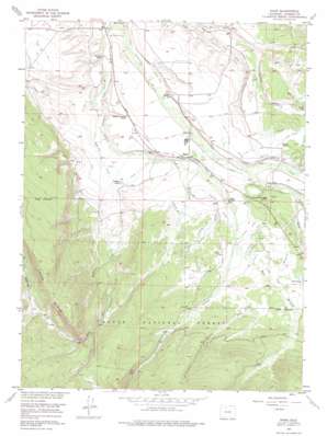
Rand Topo Map Colorado
To zoom in, hover over the map of Rand
USGS Topo Quad 40106d2 - 1:24,000 scale
| Topo Map Name: | Rand |
| USGS Topo Quad ID: | 40106d2 |
| Print Size: | ca. 21 1/4" wide x 27" high |
| Southeast Coordinates: | 40.375° N latitude / 106.125° W longitude |
| Map Center Coordinates: | 40.4375° N latitude / 106.1875° W longitude |
| U.S. State: | CO |
| Filename: | o40106d2.jpg |
| Download Map JPG Image: | Rand topo map 1:24,000 scale |
| Map Type: | Topographic |
| Topo Series: | 7.5´ |
| Map Scale: | 1:24,000 |
| Source of Map Images: | United States Geological Survey (USGS) |
| Alternate Map Versions: |
Rand CO 1956, updated 1958 Download PDF Buy paper map Rand CO 1956, updated 1958 Download PDF Buy paper map Rand CO 1956, updated 1975 Download PDF Buy paper map Rand CO 2000, updated 2004 Download PDF Buy paper map Rand CO 2011 Download PDF Buy paper map Rand CO 2013 Download PDF Buy paper map Rand CO 2016 Download PDF Buy paper map |
| FStopo: | US Forest Service topo Rand is available: Download FStopo PDF Download FStopo TIF |
1:24,000 Topo Quads surrounding Rand
> Back to 40106a1 at 1:100,000 scale
> Back to 40106a1 at 1:250,000 scale
> Back to U.S. Topo Maps home
Rand topo map: Gazetteer
Rand: Airports
Owl Ridge Heliport elevation 2614m 8576′Rand: Canals
Arnold Ditch elevation 2646m 8681′Big Willow Ditch elevation 2678m 8786′
Darcy Ditch elevation 2872m 9422′
Donelson Ditch elevation 2652m 8700′
Hanover Ditch elevation 2654m 8707′
Ish Ditch elevation 2682m 8799′
J W Sutton Ditch elevation 2701m 8861′
J W Sutton Ditch Number 2 elevation 2677m 8782′
John S Sutton Ditch elevation 2663m 8736′
Little Chief Ditch elevation 2598m 8523′
Lost Ditch elevation 2650m 8694′
Mac Farlane Extension elevation 2579m 8461′
Monroe Ditch elevation 2591m 8500′
Ottawa Ditch elevation 2578m 8458′
Peabody Ditch elevation 2629m 8625′
Salem Ditch elevation 2611m 8566′
Shearer Ditch elevation 2664m 8740′
Stella Ditch elevation 2646m 8681′
Stevenson Ditch Number 2 elevation 2592m 8503′
Welch and Peabody Ditch elevation 2629m 8625′
Welch Ditch elevation 2636m 8648′
Westfield Ditch elevation 2634m 8641′
Rand: Populated Places
Old Homestead elevation 2674m 8772′Rand elevation 2630m 8628′
Rand: Post Offices
Rand Post Office elevation 2635m 8645′Rand: Ridges
Green Ridge elevation 3040m 9973′Rand: Streams
Badgero Creek elevation 2646m 8681′East Branch Willow Creek elevation 2664m 8740′
Howd Creek elevation 2666m 8746′
Jack Creek elevation 2627m 8618′
McKinnon Creek elevation 2597m 8520′
Rock Creek elevation 2623m 8605′
Shearer Creek elevation 2635m 8645′
Spring Creek elevation 2686m 8812′
Rand: Summits
Windy Point elevation 2659m 8723′Rand: Trails
Haystack Trail elevation 2831m 9288′Rock Creek Trail elevation 2785m 9137′
Rand: Valleys
Faulkner Draw elevation 2610m 8562′Rand digital topo map on disk
Buy this Rand topo map showing relief, roads, GPS coordinates and other geographical features, as a high-resolution digital map file on DVD:


