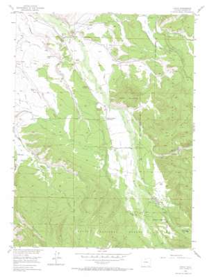
Gould Topo Map Colorado
To zoom in, hover over the map of Gould
USGS Topo Quad 40106e1 - 1:24,000 scale
| Topo Map Name: | Gould |
| USGS Topo Quad ID: | 40106e1 |
| Print Size: | ca. 21 1/4" wide x 27" high |
| Southeast Coordinates: | 40.5° N latitude / 106° W longitude |
| Map Center Coordinates: | 40.5625° N latitude / 106.0625° W longitude |
| U.S. State: | CO |
| Filename: | o40106e1.jpg |
| Download Map JPG Image: | Gould topo map 1:24,000 scale |
| Map Type: | Topographic |
| Topo Series: | 7.5´ |
| Map Scale: | 1:24,000 |
| Source of Map Images: | United States Geological Survey (USGS) |
| Alternate Map Versions: |
Gould CO 1955, updated 1957 Download PDF Buy paper map Gould CO 1955, updated 1957 Download PDF Buy paper map Gould CO 1955, updated 1963 Download PDF Buy paper map Gould CO 1955, updated 1963 Download PDF Buy paper map Gould CO 1955, updated 1971 Download PDF Buy paper map Gould CO 2000, updated 2004 Download PDF Buy paper map Gould CO 2011 Download PDF Buy paper map Gould CO 2013 Download PDF Buy paper map Gould CO 2016 Download PDF Buy paper map |
| FStopo: | US Forest Service topo Gould is available: Download FStopo PDF Download FStopo TIF |
1:24,000 Topo Quads surrounding Gould
> Back to 40106e1 at 1:100,000 scale
> Back to 40106a1 at 1:250,000 scale
> Back to U.S. Topo Maps home
Gould topo map: Gazetteer
Gould: Canals
Bradfield Ditch elevation 2633m 8638′Domestic Supply Ditch elevation 2654m 8707′
Endomile Ditch elevation 2710m 8891′
Fox Ditch elevation 2643m 8671′
Georgia Ditch elevation 2657m 8717′
Gibbs Ditch elevation 2624m 8608′
Gould Ditch elevation 2733m 8966′
Kermode Ditch elevation 2609m 8559′
Last Treasure and Georgia Ditch elevation 2708m 8884′
Longhorn Ditch elevation 2672m 8766′
Lost Treasure Ditch elevation 2686m 8812′
Lynch Ditch elevation 2664m 8740′
Mason Ditch elevation 2670m 8759′
Orb Ditch elevation 2646m 8681′
Overland Ditch elevation 2675m 8776′
Owl Ditch elevation 2633m 8638′
Owl Mountain and Domestic Supply and Mason Ditch elevation 2700m 8858′
Poverty Flat Ditch Number 1 elevation 2663m 8736′
Poverty Flat Ditch Number 2 elevation 2676m 8779′
Ravine Ditch elevation 2588m 8490′
Riley Extension Ditch elevation 2690m 8825′
Sales Ditch Number 2 elevation 2640m 8661′
Squibob Ditch elevation 2623m 8605′
Stemmer Ditch elevation 2611m 8566′
Wagon Wheel Ditch elevation 2646m 8681′
Gould: Dams
North Michigan Creek Dam elevation 2706m 8877′Gould: Populated Places
Gould elevation 2719m 8920′Stelbars Lindland elevation 2640m 8661′
Gould: Reservoirs
North Michigan Creek Reservoir elevation 2706m 8877′Gould: Streams
Dry Fork Owl Creek elevation 2642m 8667′Mill Creek elevation 2722m 8930′
No Name Creek elevation 2731m 8959′
North Fork Canadian River elevation 2623m 8605′
Peterson Creek elevation 2587m 8487′
Sales Creek elevation 2598m 8523′
South Fork Canadian River elevation 2623m 8605′
South Fork Michigan River elevation 2695m 8841′
Gould: Summits
Bull Mountain elevation 2959m 9708′Custer Mountain elevation 2826m 9271′
Michigan Hill elevation 2636m 8648′
Gould: Valleys
Custer Draw elevation 2644m 8674′Gould digital topo map on disk
Buy this Gould topo map showing relief, roads, GPS coordinates and other geographical features, as a high-resolution digital map file on DVD:


