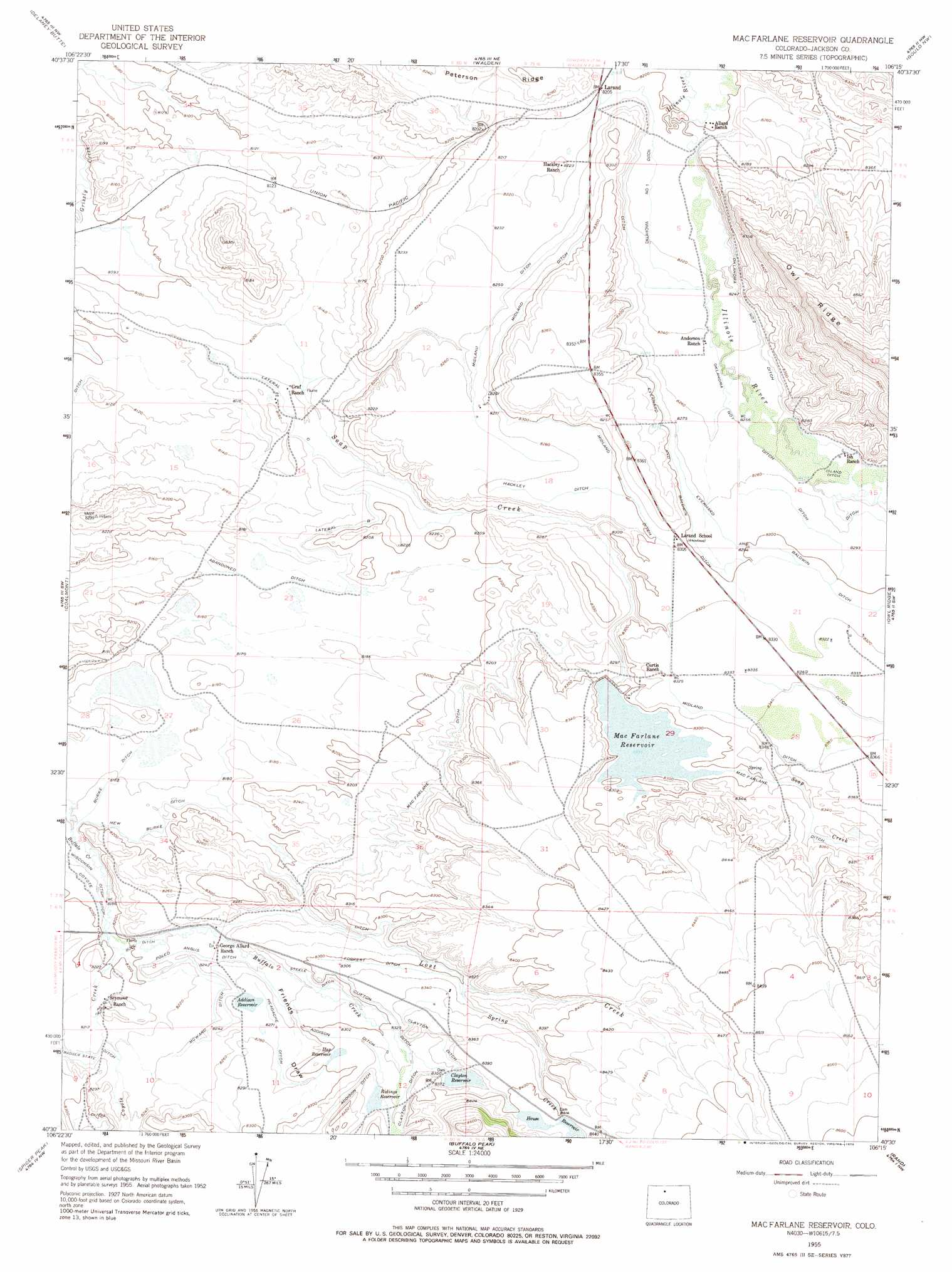
Macfarlane Reservoir Topo Map Colorado
To zoom in, hover over the map of Macfarlane Reservoir
USGS Topo Quad 40106e3 - 1:24,000 scale
| Topo Map Name: | Macfarlane Reservoir |
| USGS Topo Quad ID: | 40106e3 |
| Print Size: | ca. 21 1/4" wide x 27" high |
| Southeast Coordinates: | 40.5° N latitude / 106.25° W longitude |
| Map Center Coordinates: | 40.5625° N latitude / 106.3125° W longitude |
| U.S. State: | CO |
| Filename: | o40106e3.jpg |
| Download Map JPG Image: | Macfarlane Reservoir topo map 1:24,000 scale |
| Map Type: | Topographic |
| Topo Series: | 7.5´ |
| Map Scale: | 1:24,000 |
| Source of Map Images: | United States Geological Survey (USGS) |
| Alternate Map Versions: |
Mac Farlane Reservoir CO 1955, updated 1957 Download PDF Buy paper map Mac Farlane Reservoir CO 1955, updated 1957 Download PDF Buy paper map Mac Farlane Reservoir CO 1955, updated 1967 Download PDF Buy paper map Mac Farlane Reservoir CO 1955, updated 1967 Download PDF Buy paper map Macfarlane Reservoir CO 1955, updated 1978 Download PDF Buy paper map MacFarlane Reservoir CO 2010 Download PDF Buy paper map MacFarlane Reservoir CO 2013 Download PDF Buy paper map MacFarlane Reservoir CO 2016 Download PDF Buy paper map |
1:24,000 Topo Quads surrounding Macfarlane Reservoir
Boettcher Lake |
Lake John |
Cowdrey |
Eagle Hill |
Shipman Mountain |
Pitchpine Mountain |
Delaney Butte |
Walden |
Gould Nw |
Johnny Moore Mountain |
Teal Lake |
Coalmont |
Macfarlane Reservoir |
Owl Ridge |
Gould |
Rabbit Ears Peak |
Spicer Peak |
Buffalo Peak |
Rand |
Jack Creek Ranch |
Lake Agnes |
Whiteley Peak |
Hyannis Peak |
Parkview Mountain |
Radial Mountain |
> Back to 40106e1 at 1:100,000 scale
> Back to 40106a1 at 1:250,000 scale
> Back to U.S. Topo Maps home
Macfarlane Reservoir topo map: Gazetteer
Macfarlane Reservoir: Canals
Addison Ditch elevation 2540m 8333′Badger State Ditch elevation 2507m 8225′
Bock Ditch elevation 2505m 8218′
Burke Ditch elevation 2489m 8166′
Clayton Ditch elevation 2548m 8359′
Clifton Ditch elevation 2537m 8323′
Coyote Ditch elevation 2496m 8188′
Dryer Ditch elevation 2538m 8326′
Everhard and Baldwin Ditch elevation 2531m 8303′
Forrest Ditch elevation 2534m 8313′
Graf Ranch elevation 2483m 8146′
Hackley Ditch elevation 2526m 8287′
Headache Ditch elevation 2523m 8277′
Island Ditch elevation 2520m 8267′
Lateral C elevation 2488m 8162′
McWard Ditch elevation 2518m 8261′
Midland Ditch elevation 2536m 8320′
New Burke Ditch elevation 2495m 8185′
Oklahoma Ditch Number 1 elevation 2504m 8215′
Oklahoma Number 2 Ditch elevation 2517m 8257′
Poled Angus Ditch elevation 2512m 8241′
Steele Ditch elevation 2523m 8277′
Wisconsin Ditch elevation 2495m 8185′
Macfarlane Reservoir: Cliffs
Cape Horn elevation 2544m 8346′Macfarlane Reservoir: Dams
Clayton Dam elevation 2545m 8349′Hap Dam elevation 2531m 8303′
MacFarlane Dam elevation 2530m 8300′
Macfarlane Reservoir: Mines
Grizzly Creek Mine elevation 2516m 8254′Macfarlane Reservoir: Populated Places
Larand elevation 2503m 8211′Macfarlane Reservoir: Reservoirs
Addison Reservoir elevation 2520m 8267′Clayton Reservoir elevation 2545m 8349′
Hap Reservoir elevation 2531m 8303′
House Reservoir elevation 2564m 8412′
Mac Farlane Reservoir elevation 2530m 8300′
MacFarlane Reservoir elevation 2530m 8300′
Ridings Reservoir elevation 2544m 8346′
Macfarlane Reservoir: Streams
Coyote Creek elevation 2507m 8225′Lost Creek elevation 2511m 8238′
Spring Creek elevation 2537m 8323′
Macfarlane Reservoir: Valleys
Friend Draw elevation 2529m 8297′Macfarlane Reservoir digital topo map on disk
Buy this Macfarlane Reservoir topo map showing relief, roads, GPS coordinates and other geographical features, as a high-resolution digital map file on DVD: