Mount Ethel Topo Map Colorado
To zoom in, hover over the map of Mount Ethel
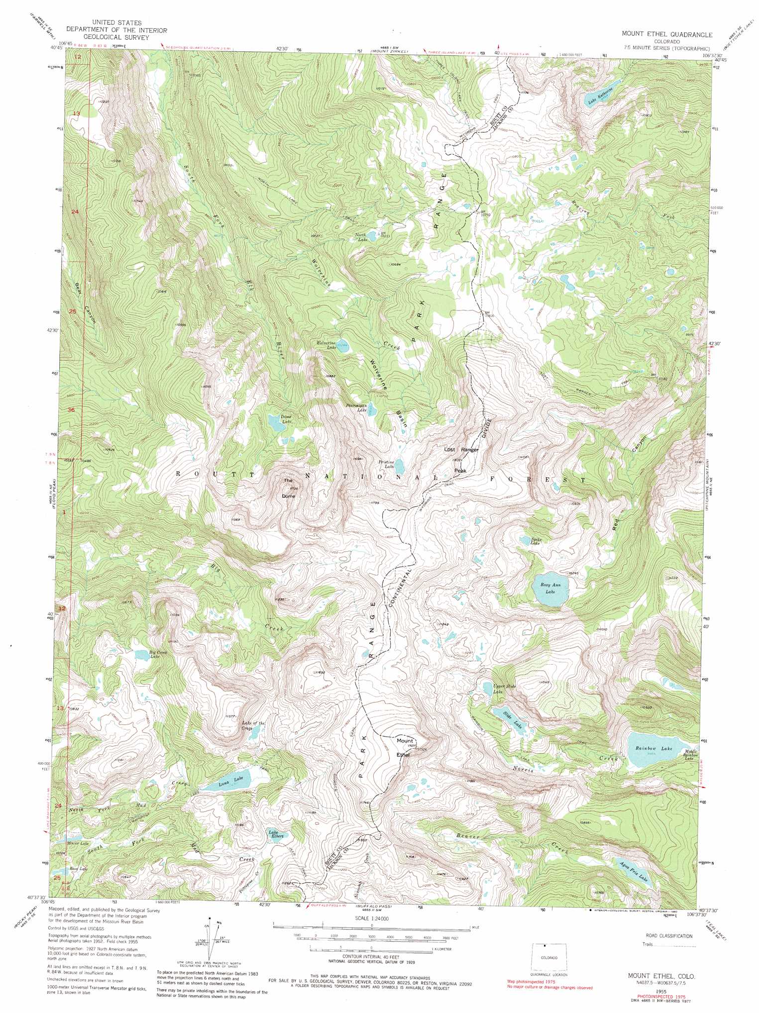
USGS Topo Quad 40106f6 - 1:24,000 scale
| Topo Map Name: | Mount Ethel |
| USGS Topo Quad ID: | 40106f6 |
| Print Size: | ca. 21 1/4" wide x 27" high |
| Southeast Coordinates: | 40.625° N latitude / 106.625° W longitude |
| Map Center Coordinates: | 40.6875° N latitude / 106.6875° W longitude |
| U.S. State: | CO |
| Filename: | o40106f6.jpg |
| Download Map JPG Image: | Mount Ethel topo map 1:24,000 scale |
| Map Type: | Topographic |
| Topo Series: | 7.5´ |
| Map Scale: | 1:24,000 |
| Source of Map Images: | United States Geological Survey (USGS) |
| Alternate Map Versions: |
Mount Ethel CO 1955, updated 1957 Download PDF Buy paper map Mount Ethel CO 1955, updated 1957 Download PDF Buy paper map Mount Ethel CO 1955, updated 1963 Download PDF Buy paper map Mount Ethel CO 1955, updated 1969 Download PDF Buy paper map Mount Ethel CO 1955, updated 1969 Download PDF Buy paper map Mount Ethel CO 1955, updated 1980 Download PDF Buy paper map Mount Ethel CO 2000, updated 2004 Download PDF Buy paper map Mount Ethel CO 2011 Download PDF Buy paper map Mount Ethel CO 2013 Download PDF Buy paper map Mount Ethel CO 2016 Download PDF Buy paper map |
| FStopo: | US Forest Service topo Mount Ethel is available: Download FStopo PDF Download FStopo TIF |
1:24,000 Topo Quads surrounding Mount Ethel
Elkhorn Mountain |
West Fork Lake |
Davis Peak |
Pearl |
Independence Mountain |
Hahns Peak |
Farwell Mountain |
Mount Zirkel |
Boettcher Lake |
Lake John |
Clark |
Floyd Peak |
Mount Ethel |
Pitchpine Mountain |
Delaney Butte |
Mad Creek |
Rocky Peak |
Buffalo Pass |
Teal Lake |
Coalmont |
Cow Creek |
Steamboat Springs |
Mount Werner |
Rabbit Ears Peak |
Spicer Peak |
> Back to 40106e1 at 1:100,000 scale
> Back to 40106a1 at 1:250,000 scale
> Back to U.S. Topo Maps home
Mount Ethel topo map: Gazetteer
Mount Ethel: Basins
Wolverine Basin elevation 3227m 10587′Mount Ethel: Dams
Aqua Fria Dam elevation 3057m 10029′Mount Ethel: Lakes
Agua Fria Lake elevation 3055m 10022′Big Creek Lake elevation 3238m 10623′
Dome Lake elevation 3071m 10075′
Lake Elbert elevation 3287m 10784′
Lake Katherine elevation 3007m 9865′
Lake of the Crags elevation 3311m 10862′
Lakes of the Crags elevation 3307m 10849′
Luna Lake elevation 3197m 10488′
Mirror Lake elevation 3058m 10032′
North Lake elevation 3144m 10314′
Pristine Lake elevation 3364m 11036′
Ptarmigan Lake elevation 3263m 10705′
Rainbow Lake elevation 3005m 9858′
Rosa Lake elevation 3057m 10029′
Roxy Ann Lake elevation 3103m 10180′
Slide Lake elevation 3210m 10531′
Spike Lake elevation 3180m 10433′
Upper Slide Lake elevation 3275m 10744′
Wolverine Lake elevation 3136m 10288′
Mount Ethel: Ranges
Park Range elevation 3557m 11669′Mount Ethel: Reservoirs
Aqua Fria Reservoir elevation 3057m 10029′Mount Ethel: Streams
Wolverine Creek elevation 2946m 9665′Mount Ethel: Summits
Lost Ranger Peak elevation 3641m 11945′Mount Ethel elevation 3625m 11893′
The Dome elevation 3581m 11748′
Mount Ethel: Trails
Big Creek Lake Trail elevation 3266m 10715′Crags Trail elevation 3406m 11174′
Lost Ranger Trail elevation 2883m 9458′
North Lake Trail elevation 2863m 9393′
Rainbow Lake Trail elevation 3020m 9908′
Wyoming Trail elevation 3540m 11614′
Mount Ethel digital topo map on disk
Buy this Mount Ethel topo map showing relief, roads, GPS coordinates and other geographical features, as a high-resolution digital map file on DVD: