Elkhorn Mountain Topo Map Colorado
To zoom in, hover over the map of Elkhorn Mountain
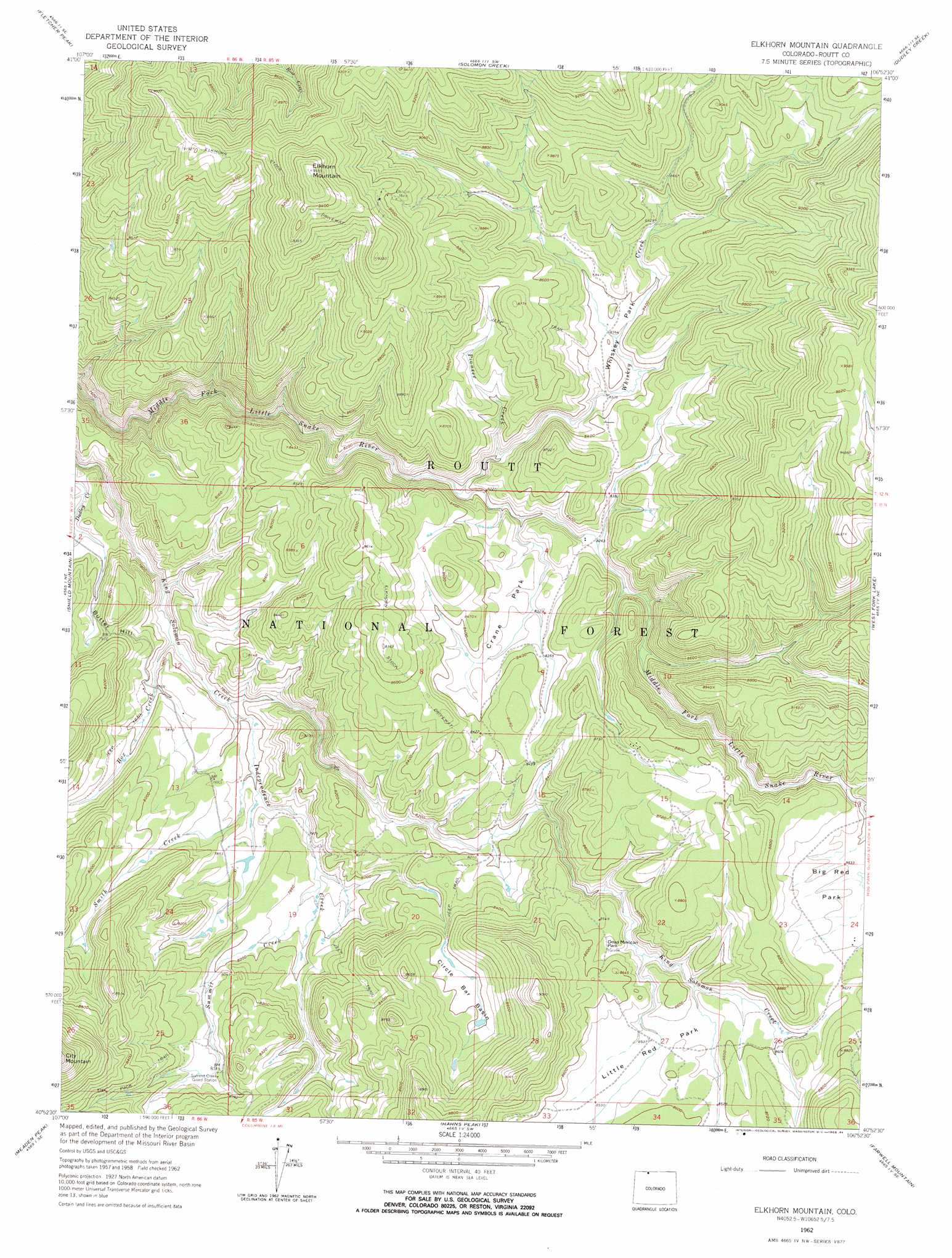
USGS Topo Quad 40106h8 - 1:24,000 scale
| Topo Map Name: | Elkhorn Mountain |
| USGS Topo Quad ID: | 40106h8 |
| Print Size: | ca. 21 1/4" wide x 27" high |
| Southeast Coordinates: | 40.875° N latitude / 106.875° W longitude |
| Map Center Coordinates: | 40.9375° N latitude / 106.9375° W longitude |
| U.S. State: | CO |
| Filename: | o40106h8.jpg |
| Download Map JPG Image: | Elkhorn Mountain topo map 1:24,000 scale |
| Map Type: | Topographic |
| Topo Series: | 7.5´ |
| Map Scale: | 1:24,000 |
| Source of Map Images: | United States Geological Survey (USGS) |
| Alternate Map Versions: |
Elkhorn Mountain CO 1962, updated 1964 Download PDF Buy paper map Elkhorn Mountain CO 1962, updated 1964 Download PDF Buy paper map Elkhorn Mountain CO 1962, updated 1969 Download PDF Buy paper map Elkhorn Mountain CO 1962, updated 1969 Download PDF Buy paper map Elkhorn Mountain CO 2000, updated 2004 Download PDF Buy paper map Elkhorn Mountain CO 2011 Download PDF Buy paper map Elkhorn Mountain CO 2013 Download PDF Buy paper map Elkhorn Mountain CO 2016 Download PDF Buy paper map |
| FStopo: | US Forest Service topo Elkhorn Mountain is available: Download FStopo PDF Download FStopo TIF |
1:24,000 Topo Quads surrounding Elkhorn Mountain
Singer Peak |
Bridger Peak |
Red Mountain |
Encampment |
Gunst Reservoir |
Cottonwood Rim |
Fletcher Peak |
Solomon Creek |
Dudley Creek |
Blackhall Mountain |
Tumble Mountain |
Shield Mountain |
Elkhorn Mountain |
West Fork Lake |
Davis Peak |
Bears Ears Peaks |
Meaden Peak |
Hahns Peak |
Farwell Mountain |
Mount Zirkel |
Quaker Mountain |
Pilot Knob |
Clark |
Floyd Peak |
Mount Ethel |
> Back to 40106e1 at 1:100,000 scale
> Back to 40106a1 at 1:250,000 scale
> Back to U.S. Topo Maps home
Elkhorn Mountain topo map: Gazetteer
Elkhorn Mountain: Dams
McCargar Dam elevation 2402m 7880′Elkhorn Mountain: Flats
Big Red Park elevation 2635m 8645′Circle Bar Basin elevation 2557m 8389′
Crane Park elevation 2540m 8333′
Dead Mexican Park elevation 2606m 8549′
Little Red Park elevation 2600m 8530′
Whiskey Park elevation 2550m 8366′
Elkhorn Mountain: Mines
Elkhorn Mine elevation 2736m 8976′King Solomon Creek Mine elevation 2497m 8192′
Little Snake Mine elevation 2561m 8402′
Middle Fork Lode elevation 2513m 8244′
Whiskey Park Mine elevation 2610m 8562′
Elkhorn Mountain: Reservoirs
McCargar Reservoir elevation 2402m 7880′Elkhorn Mountain: Streams
Box Creek elevation 2350m 7709′Independence Creek elevation 2363m 7752′
Pioneer Creek elevation 2499m 8198′
Silver City Creek elevation 2622m 8602′
Smith Creek elevation 2405m 7890′
Summit Creek elevation 2413m 7916′
Whiskey Creek elevation 2488m 8162′
Whiskey Creek elevation 2488m 8162′
Elkhorn Mountain: Summits
Butter Hill elevation 2429m 7969′Elkhorn Mountain elevation 2909m 9543′
Elkhorn Mountain digital topo map on disk
Buy this Elkhorn Mountain topo map showing relief, roads, GPS coordinates and other geographical features, as a high-resolution digital map file on DVD: