Orno Peak Topo Map Colorado
To zoom in, hover over the map of Orno Peak
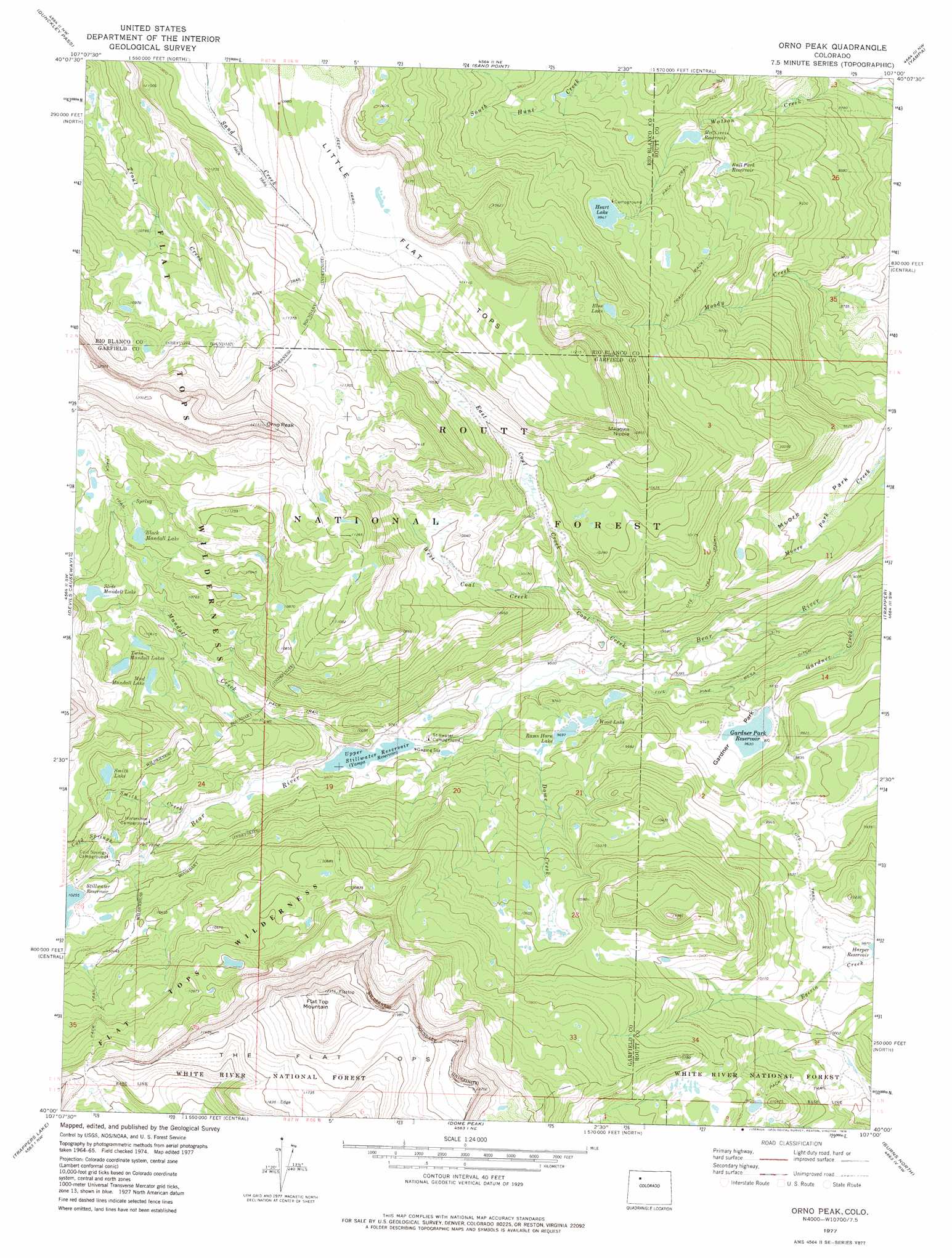
USGS Topo Quad 40107a1 - 1:24,000 scale
| Topo Map Name: | Orno Peak |
| USGS Topo Quad ID: | 40107a1 |
| Print Size: | ca. 21 1/4" wide x 27" high |
| Southeast Coordinates: | 40° N latitude / 107° W longitude |
| Map Center Coordinates: | 40.0625° N latitude / 107.0625° W longitude |
| U.S. State: | CO |
| Filename: | o40107a1.jpg |
| Download Map JPG Image: | Orno Peak topo map 1:24,000 scale |
| Map Type: | Topographic |
| Topo Series: | 7.5´ |
| Map Scale: | 1:24,000 |
| Source of Map Images: | United States Geological Survey (USGS) |
| Alternate Map Versions: |
Orno Peak CO 1977, updated 1978 Download PDF Buy paper map Orno Peak CO 2000, updated 2004 Download PDF Buy paper map Orno Peak CO 2011 Download PDF Buy paper map Orno Peak CO 2013 Download PDF Buy paper map Orno Peak CO 2016 Download PDF Buy paper map |
| FStopo: | US Forest Service topo Orno Peak is available: Download FStopo PDF Download FStopo TIF |
1:24,000 Topo Quads surrounding Orno Peak
Hayden Gulch |
Dunckley |
Rattlesnake Butte |
Oak Creek |
Blacktail Mountain |
Pagoda Peak |
Dunckley Pass |
Sand Point |
Yampa |
Green Ridge |
Ripple Creek |
Devils Causeway |
Orno Peak |
Trapper |
Toponas |
Big Marvine Peak |
Trappers Lake |
Dome Peak |
Burns North |
Blue Hill |
Deep Lake |
Sweetwater Lake |
Sugarloaf Mountain |
Burns South |
Castle Peak |
> Back to 40107a1 at 1:100,000 scale
> Back to 40106a1 at 1:250,000 scale
> Back to U.S. Topo Maps home
Orno Peak topo map: Gazetteer
Orno Peak: Dams
Bull Park Number 2 Dam elevation 2865m 9399′Gardner Park Dam elevation 3080m 10104′
Harper Reservoir Dam elevation 3052m 10013′
Heart Lake Dam elevation 3034m 9954′
McChivvis Dam elevation 2767m 9078′
Rams Horn Dam elevation 2958m 9704′
Stillwater Number 1 Dam elevation 3135m 10285′
Upper Stillwater Dam elevation 2980m 9776′
Yamcolo Dam elevation 2898m 9507′
Orno Peak: Flats
Gardner Park elevation 2936m 9632′Moore Park elevation 2842m 9324′
Orno Peak: Gaps
Mandall Pass elevation 3619m 11873′Orno Peak: Lakes
Benton Lake elevation 3153m 10344′Black Mandall Lake elevation 3298m 10820′
Blue Lake elevation 3143m 10311′
Heart Lake elevation 3034m 9954′
Mud Mandall Lake elevation 3213m 10541′
Rams Horn Lake elevation 2957m 9701′
Slide Mandall Lake elevation 3249m 10659′
Smith Lake elevation 3200m 10498′
Twin Mandall Lakes elevation 3221m 10567′
Wood Lake elevation 2957m 9701′
Orno Peak: Reservoirs
Bear Lake Reservoir elevation 2980m 9776′Bull Park Reservoir elevation 2864m 9396′
Bull Park Reservoir Number 2 elevation 2865m 9399′
Gardner Park Reservoir elevation 2936m 9632′
Harper Reservoir elevation 3052m 10013′
Heart Lake elevation 3080m 10104′
McChivvis Reservoir elevation 2884m 9461′
McChivvis Reservoir elevation 2767m 9078′
Rams Horn Reservoir elevation 2958m 9704′
Stillwater Reservoir elevation 3128m 10262′
Stillwater Reservoir Number 1 elevation 3135m 10285′
Upper Stillwater Reservoir elevation 2969m 9740′
Yamcolo Reservoir elevation 2898m 9507′
Orno Peak: Streams
Coal Creek elevation 2863m 9393′Cold Springs Creek elevation 3101m 10173′
Dome Creek elevation 2898m 9507′
East Coal Creek elevation 2969m 9740′
Gardner Creek elevation 2745m 9005′
Mandall Creek elevation 2970m 9744′
Smith Creek elevation 3021m 9911′
West Coal Creek elevation 2969m 9740′
Orno Peak: Summits
Flat Top Mountain elevation 3554m 11660′Little Flat Tops elevation 3419m 11217′
Maggies Nipple elevation 3331m 10928′
Orno Peak elevation 3696m 12125′
Orno Peak: Trails
Ute Trail elevation 3008m 9868′Orno Peak digital topo map on disk
Buy this Orno Peak topo map showing relief, roads, GPS coordinates and other geographical features, as a high-resolution digital map file on DVD: