Lost Park Topo Map Colorado
To zoom in, hover over the map of Lost Park
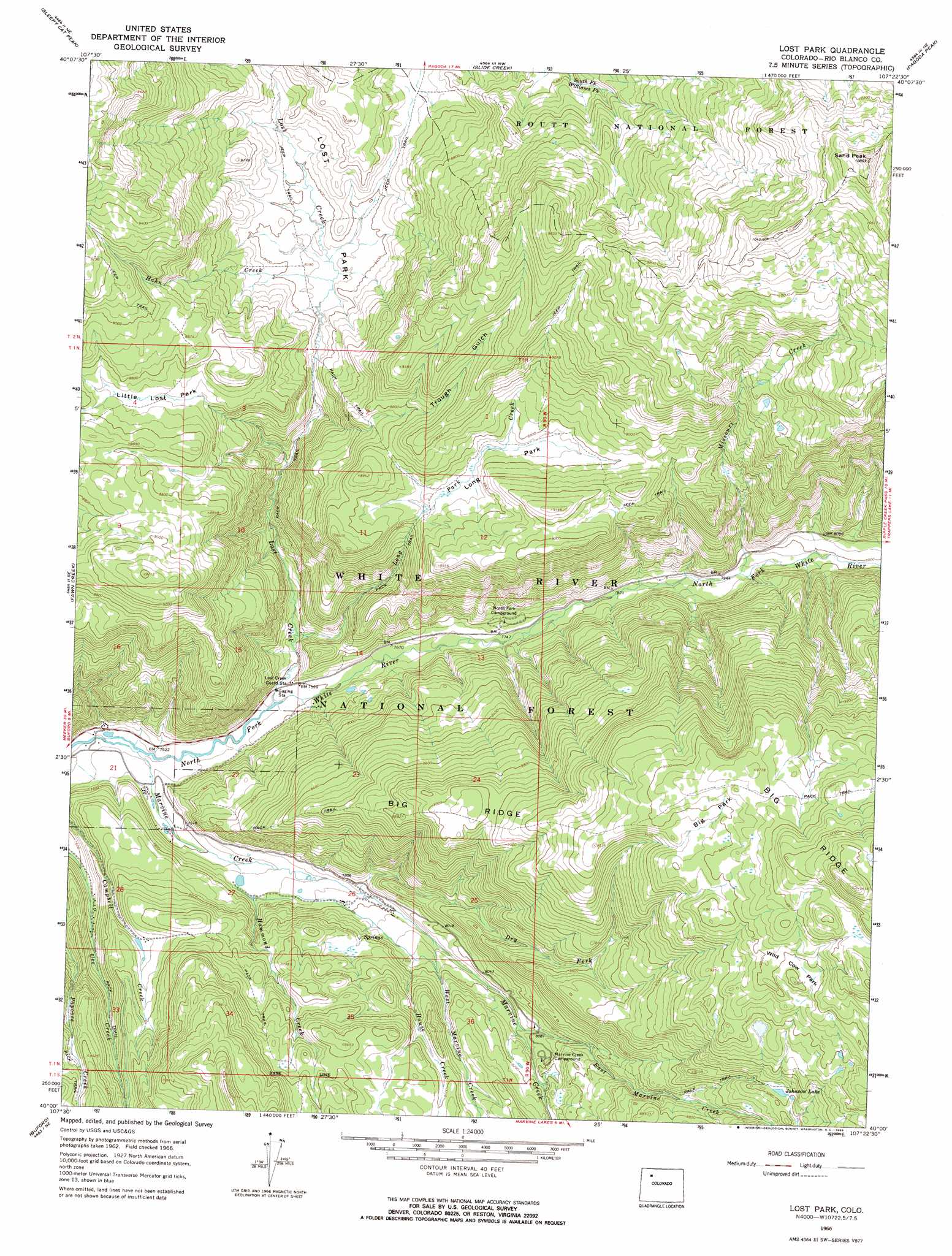
USGS Topo Quad 40107a4 - 1:24,000 scale
| Topo Map Name: | Lost Park |
| USGS Topo Quad ID: | 40107a4 |
| Print Size: | ca. 21 1/4" wide x 27" high |
| Southeast Coordinates: | 40° N latitude / 107.375° W longitude |
| Map Center Coordinates: | 40.0625° N latitude / 107.4375° W longitude |
| U.S. State: | CO |
| Filename: | o40107a4.jpg |
| Download Map JPG Image: | Lost Park topo map 1:24,000 scale |
| Map Type: | Topographic |
| Topo Series: | 7.5´ |
| Map Scale: | 1:24,000 |
| Source of Map Images: | United States Geological Survey (USGS) |
| Alternate Map Versions: |
Lost Park CO 1966, updated 1969 Download PDF Buy paper map Lost Park CO 2011 Download PDF Buy paper map Lost Park CO 2013 Download PDF Buy paper map Lost Park CO 2016 Download PDF Buy paper map |
| FStopo: | US Forest Service topo Lost Park is available: Download FStopo PDF Download FStopo TIF |
1:24,000 Topo Quads surrounding Lost Park
Monument Butte |
Hamilton |
Pagoda |
Hayden Gulch |
Dunckley |
Thornburgh |
Sleepy Cat Peak |
Slide Creek |
Pagoda Peak |
Dunckley Pass |
Sawmill Mountain |
Fawn Creek |
Lost Park |
Ripple Creek |
Devils Causeway |
Big Beaver Reservoir |
Buford |
Oyster Lake |
Big Marvine Peak |
Trappers Lake |
Triangle Park |
Meadow Creek Lake |
Blair Mountain |
Deep Lake |
Sweetwater Lake |
> Back to 40107a1 at 1:100,000 scale
> Back to 40106a1 at 1:250,000 scale
> Back to U.S. Topo Maps home
Lost Park topo map: Gazetteer
Lost Park: Flats
Big Park elevation 2921m 9583′Little Lost Park elevation 2649m 8690′
Long Park elevation 2844m 9330′
Lost Park elevation 2570m 8431′
Wild Cow Park elevation 2925m 9596′
Lost Park: Lakes
Johnson Lake elevation 2751m 9025′Lost Park: Ridges
Big Ridge elevation 2904m 9527′Lost Park: Streams
Dry Fork Marvine Creek elevation 2366m 7762′East Marvine Creek elevation 2445m 8021′
Hahn Creek elevation 2546m 8353′
Hammond Creek elevation 2327m 7634′
House Creek elevation 2421m 7942′
Long Park Creek elevation 2324m 7624′
Lost Creek elevation 2299m 7542′
Marvine Creek elevation 2277m 7470′
Missouri Creek elevation 2716m 8910′
West Marvine Creek elevation 2395m 7857′
Lost Park: Summits
Sand Peak elevation 3303m 10836′Lost Park: Valleys
Trough Gulch elevation 2472m 8110′Lost Park digital topo map on disk
Buy this Lost Park topo map showing relief, roads, GPS coordinates and other geographical features, as a high-resolution digital map file on DVD: